


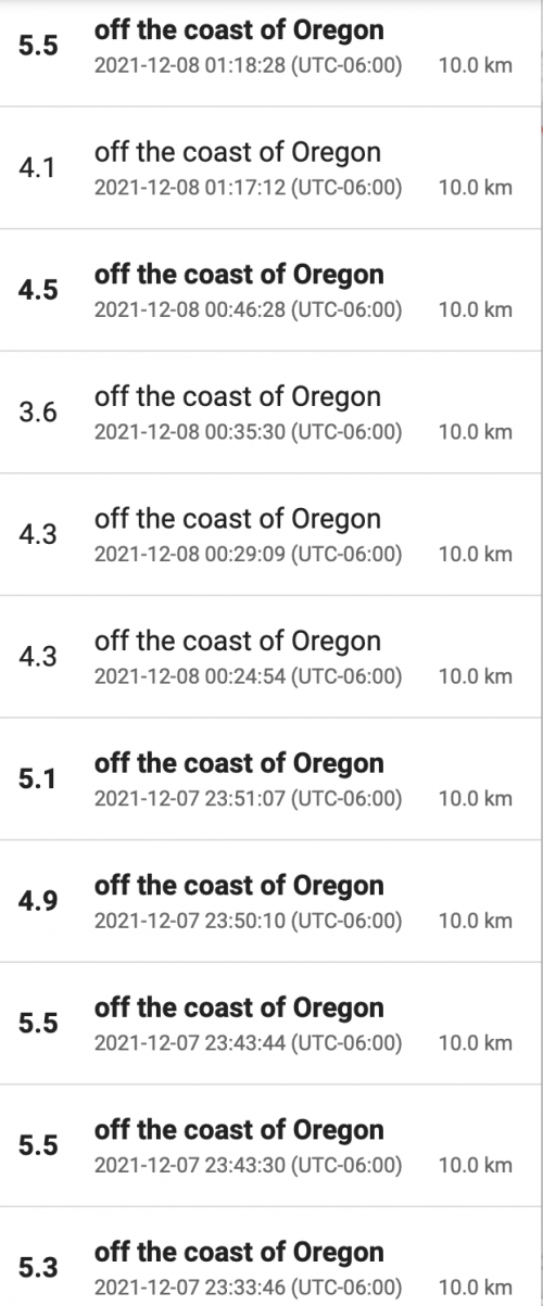
Dozens of earthquakes
The U.S. Geological Survey (USGS) reported dozens of small-to-moderate earthquakes off the Oregon coast this week, beginning at 5:21 a.m. Pacific Time (13:21 UTC) on December 7, 2021. That initial quake was 4.2 magnitude. Since then, as of this writing, there have been 78 small-to-moderate earthquakes (magnitude 2.5 or greater) in the ocean off the Oregon coast, with the last one – a magnitude-3.6 quake – occurring at 1:06 a.m. Pacific Time (9:06 UTC) on December 9. There were two 5.8-magnitude quakes in this swarm. But most of the earthquakes were relatively small, according to USGS. Earthquakes in the ocean sometimes cause tsunamis. But no tsunamis were ever expected from this week’s earthquake swarm off the Oregon coast.
Still, it’s an interesting series. Earthquakes often happen in groups in this way, although it’s unusual to see so many earthquakes as in this week’s Oregon swarm. The swarm is of special interest because it’s happening off the coast of a heavily populated region. Are some of these earthquakes foreshocks or aftershocks? Sure. We often see a dozen or so foreshocks and aftershocks around a primary earthquake. These terms are relative and easiest to sort out once a series of earthquakes has stopped.
Has it stopped? It’s unknown at this time how many more earthquakes might occur in the Pacific, off the Oregon coast, today or tomorrow. Want to follow them yourself? Instructions below.
EarthSky 2022 lunar calendars now available! They make great gifts. Order now. Going fast!
How to track an earthquake swarm
Lee Siegel of Beverly Beach, Oregon, who is a retired science writer for AP, Salt Lake Tribune, University of Utah and Space.com, and who’s been following the swarm’s progress at USGS emailed yesterday with a solid description of how to track an earthquake swarm like this one via USGS. He wrote:
If you are monitoring the quake swarm off the Oregon coast, be aware the USGS Latest Quakes page by default shows only the last 24 hours worth of quakes, and only those 2.5 magnitude and larger. So some of the first quakes in the swarm early Tuesday already have dropped off the map.
If you want to see the entire swarm and get an accurate count, do this.
1. Go to the USGS Latest Quakes page: https://earthquake.usgs.gov/earthquakes/map
2. Move the map with your cursor so the offshore swarm is in the middle. Then use the “+” button near the upper left to zoom in on the swarm until only quakes in the swarm show on the map. You will have to
alternate between using your cursor to keep the swarm in the center of the map and zoom until no quakes other than those in the swarm are shown.3. In the upper left above the list of quakes, check the box that says: “Only List Earthquakes Shown on Map”.
4.Click the gear symbol near the upper right. It likely will be checked on “1 day, Magnitude 2.5+ U.S.” Change that by checking “7 Days, Magnitude 2.5+ U.S.”
The current swarm began with a 4.2-magnitude quake at 5:21 a.m. Pacific on Tuesday, December 7, 2021.
If the swarm goes on more than a week, change the check mark on the right to: “30 days, Magnitude 2.5+ U.S.”, but don’t count any quakes earlier than the first one at 5:21 a.m. Pacific (13:21 UTC) Tuesday, December 7.
A caution: This swarm likely has had hundreds of quakes if you add those less than magnitude 2.5. But there are so many, the USGS doesn’t “locate” and list most of these quakes. They will eventually add those under 2.5 that they can locate to the list, but the National Earthquake Information Center told me this morning that can take a month or more.
Earthquakes happen every day
Dozens of earthquakes of greater than 2.5-magnitude happen all around the globe, every day.
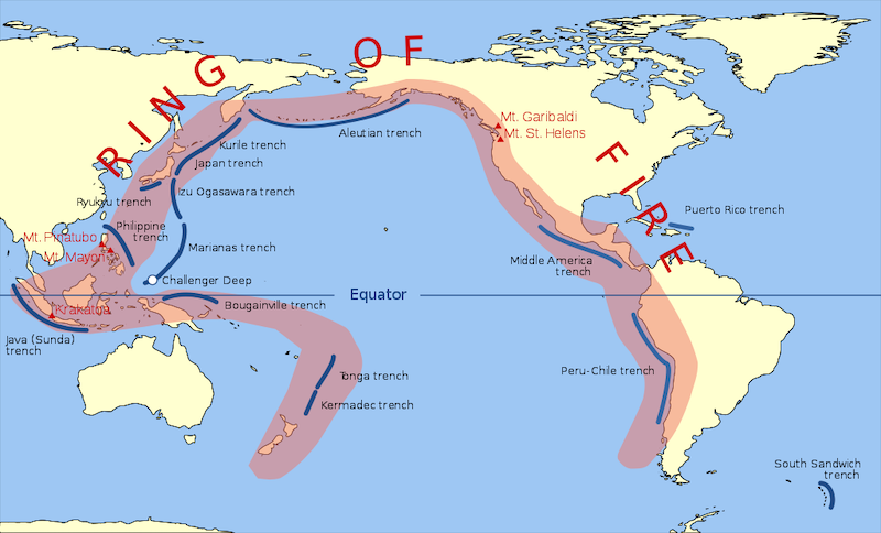
Earthquakes are common along the western coast of North America, because western North America borders what’s called the Ring of Fire, the most seismically and volcanically active zone in the world. The Ring of Fire is a horseshoe-shaped swath – 24,900 miles (40,000 km) long – dotted with seismically active locations. Over 80 per cent of large earthquakes occur along the Ring of Fire, where the Pacific plate is being subducted beneath the surrounding plates.
Pressure building, pressure releasing
An earthquake series like this can be seen as a release of the pressure that’s been building between land plates along this region of the Ring of Fire. Better a lot of little earthquakes than one big one. Small-to-moderate earthquakes like those in this week’s swarm off the coast of Oregon remind us of the cataclysmic earthquake geologists say will happen when the pressure building between the Juan de Fuca and North American plates breaks. Oregon officials have said that, according to scientists, there’s a 37% chance of a 7.1-magnitude or higher earthquake at the boundary between the two tectonic plates, called the Cascadia subduction zone, in the next 50 years.
But Lee Siegel ee pointed out:
This swarm is not on the Cascadia subduction zone that has produced numerous magnitude-9+ quakes prehistorically and is located where the west edge of the Juan de Fuca plate dives under the North American plate. This week’s swarm is farther west, on part of the boundary between the west edge of the Juan de Fuca plate and the east edge of the Pacific Plate. And it is not where those two plates smash into each other, but on the transform part of the boundary, called the Blanco fracture zone, where the Pacific plate is sliding past the Juan de Fuca plate in a strike-slip faulting pattern.
Thank you, Lee! Have fun tracking earthquakes, everyone!
Bottom line: Here’s how to track an earthquake swarm on the USGS Latest Earthquakes page. Plus an update on the dozens of small-to-moderate earthquakes occurring in the ocean west of Oregon on December 7 to 9, 2021.
Like what you read?
Subscribe and receive daily news delivered to your inbox.
More from
Deborah Byrd


