


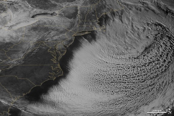
This image was taken by a NASA/NOAA weather satellite on Sunday (February 15) at 3:45 p.m. EST. By that time, the storm that battered the northeastern United States on February 14-15 was mostly out to sea. Note the comma-like shape of the nor’easter, which spawned blizzard conditions at coastal locations.
A nor’easter gets its name from the direction the wind is coming in from the storm. The wind on land, therefore, will generally blow from the northeast. The term is most often used in the coastal areas of New England. A nor’easter is a low pressure area that often passes just off the New England and southeast Canada Atlantic coastline. Winds in the left-forward quadrant rotate onto land from the northeast.
This nor’easter brought 12 to 20 inches (30 to 50 centimeters) of snow across much of eastern New England, along with tropical storm force winds over 60 miles (100 kilometers) per hour. The snowfall pushed Boston to its highest monthly total on record — 58 inches and counting — and its third highest yearly snow total. As of February 17, the snow depth near Boston was greater than in all but two reported locations in Alaska. It was significantly higher than the notoriously snowy states of Michigan, Wisconsin, and Minnesota. Only Buffalo, New York, had a higher snow pack.
Enjoying EarthSky? Sign up for our free daily newsletter today!
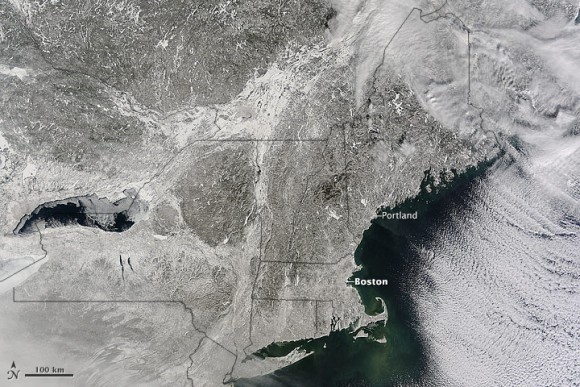
The satellite image above shows the snow-covered northeastern states on February 16, 2015. Cloud streets over the Atlantic Ocean in both images hint at the potent winds blowing across the East Coast from the Canadian interior. Following the blizzard, temperatures dropped as low as -30 degrees Fahrenheit (-34° Celsius) in parts of New England.
What the images do not show is snow depth. With the latest storm, nearly 8 feet (2.4 meters) of snow has fallen on the city of Boston in just three weeks. With temperatures persistently below freezing, very little snow has melted. According to National Climatic Data Center statistics the snow depth just south of Boston were roughly 42 inches (107 centimeters). Totals were above 30 inches (76 centimeters) in many locations in Maine, New Hampshire, and Massachusetts.
On February 16-17, more snow and ice fell across the eastern United States from northern Mississippi all the way to Maine.
Bottom line: Two NASA/NOAA satellite images of the blizzard that battered the northeastern United States on February 14-15, 2015.
Like what you read?
Subscribe and receive daily news delivered to your inbox.
More from
Eleanor Imster


