A strong area of low pressure is developing across New Mexico and is expected to strengthen today (Monday, December 19, 2011) and into Tuesday. The area of low pressure will produce heavy snow across northeast New Mexico, the Texas and Oklahoma panhandles, and into western Kansas. Snowfall accumulations of over a foot are possible in many areas. Winds will be relatively strong, and blowing snow will be a huge issue. Further east of the areas under blizzard conditions, a severe weather aspect is possible across central and southeastern Texas. The main threat for these areas will include strong winds and isolated tornadoes. Overall, a very dynamic system is developing and will likely cause problems across the United States early this week.
Take a look at the developing system this morning from the National Weather Service (NWS) radar:
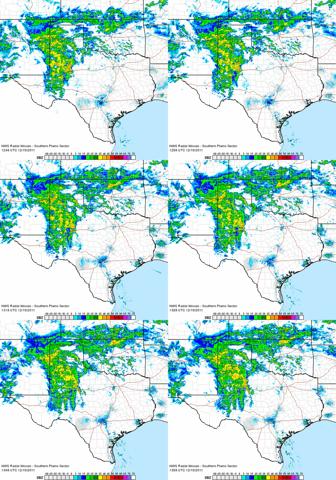
The biggest story from this storm will likely occur later tonight as the heavy snow forms and wind speeds increase. Blizzard warnings are in effect for northeast New Mexico, southeast Colorado, the Texas and Oklahoma panhandles, and western Kansas. Cities included in the blizzard warnings are Amarillo, Dodge City, Springfield, and Santa Rosa. The NWS defines a blizzard as a a storm which contains large amounts of snow OR blowing snow, with winds in excess of 35 mph and visibilities of less than 1/4 mile for an extended period of time (at least 3 hours). Everyone is urged to avoid travel in these areas until after the storm passes. Temperatures will likely drop into 20s as the upper level low moves into these areas. Road conditions have already deteriorated across central and northeast New Mexico.
Snowfall totals are very impressive with this storm. Here’s a couple of maps from the NWS in Albuquerque, New Mexico and Amarillo, Texas showing the expected snowfall accumulations:
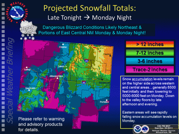
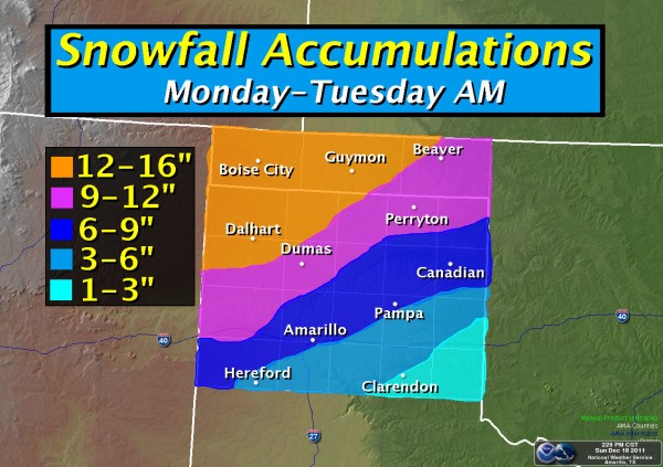
Numerous winter storm warnings have also been issued across central New Mexico and Kansas. Winter storm warnings are storms that are capable of producing a mixture of heavy snow, ice, sleet, cold temperatures, and can disrupt motorists on roads. If wind speeds push over 35 mph for over three hours, the NWS upgrades the winter storm warning into a blizzard warning.
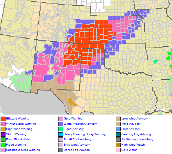
Here’s a nice overview created by the NWS in Albuquerque, New Mexico describing the differences between advisories, watches and warnings for wintry weather:

The other story regarding this storm system is the severe weather impacts across Texas and eventually the deep south Tuesday. A slight risk for severe weather is likely for central and eastern Texas later this evening. The biggest threats include isolated tornadoes and strong winds over 60 mph. Severe weather in December is not uncommon, but it’s typically nothing compared to the severe weather outbreaks we would typically see in the spring or early fall seasons. There is a lot of wind shear, warm air advection, and spin in the atmosphere to help bring strong winds to the surface. Most of the severe weather that occurs in the wintertime has limited instability to work with. If instability is low, than the severe weather threat can become minimal. However, we have seen many times in history that low instability and high wind shear events can cause significant damage. The images below show the NOAA/NWS Storm Prediction Center’s maps on the severe weather threat for late afternoon and evening across Texas. The second image shows the tornado threat, and the third image shows the wind threat possible with these storms:
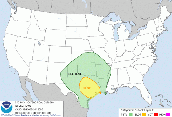
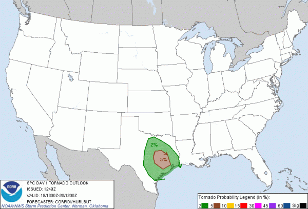
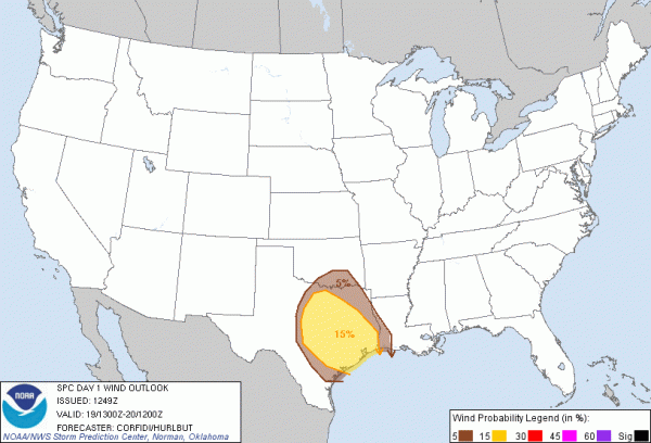
I believe the biggest headline from this storm will be the blizzard conditions across New Mexico, the Oklahoma and Texas panhandles, southeast Colorado, and western Kansas. Many areas could receive over a foot of snow, and all motorists are urged to stay off the roads until after the storm passes. Severe weather will be possible for central and southeastern Texas this evening as the area of low pressure pushes to the northeast. The biggest threat includes isolated tornadoes and strong winds over 60 mph. I believe that any tornadoes that do develop will be relatively weak (EF-0 to EF-2 strength). The same area of storms will push east Tuesday and provide a slight risk for severe weather across eastern Mississippi and western Alabama. By late Tuesday, the storm will push further to the north and east carrying the strongest dynamics with it. With that said, severe weather should diminish across the southeast as the low weakens and the overall dynamics that influence severe weather lessen. The best news about this system is that it will provide beneficial rain to the drought-stricken areas of Texas. Many areas will see at least 0.50 inches of rain, with some areas receiving over an inch within the next two days. Stay safe, listen and follow all warnings and procedures, and please avoid travel in areas experiencing winter storm and blizzard warnings.
Bottom line: Area of low pressure across New Mexico will trigger blizzard conditions and severe weather across the central United States early this week.


