


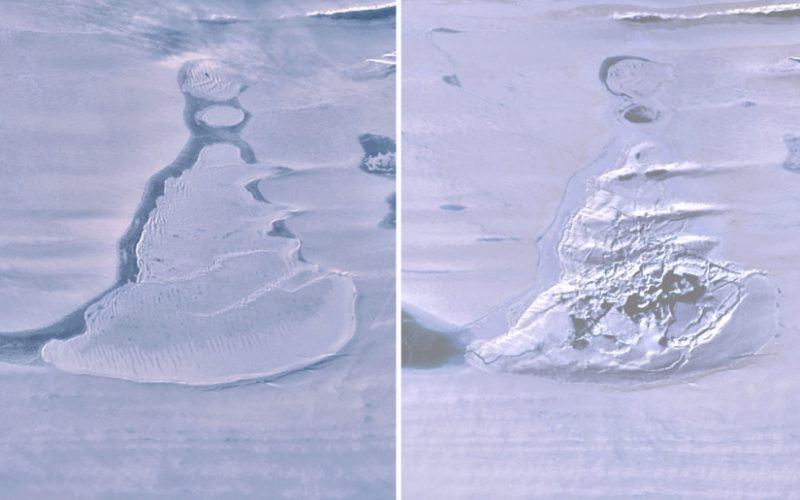
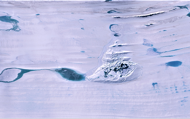
Now you see it, now you don’t
Scientists saw an ice-covered lake atop the Amery Ice Shelf in Antarctica in April 2019. But by June of that year it had drained away, leaving behind a doline – a crater-like sinkhole with the fractured remains of the ice cover – where the lake had once been. The scientists believe the weight of accumulated meltwater created a large fissure beneath the lake, which drained in June in what they said was a “rare event.”
The team of scientists published their study in the peer-reviewed journal Geophysical Research Letters on June 23, 2021. Lead author Roland Warner of the Australian Antarctic Program Partnership at the University of Tasmania said:
We believe the weight of water accumulated in this deep lake opened a fissure in the ice shelf beneath the lake, a process known as hydrofracture, causing the water to drain away to the ocean below.
Hydrofracture is a fracturing of rock, caused by water, often as it freezes to ice. Scientists have seen hydrofracturing in process on ice shelves in Antarctica. But they hadn’t seen it on such a large ice shelf. The Amery Ice Shelf, where this lake once stood, is 4,590 feet (1,400 meters) thick.
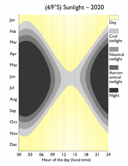
How to see in the dark of polar winter
The Amery Ice Shelf is located at 69 degrees south. June is wintertime in the Southern Hemisphere, when it’s dark nearly all the time at this ice shelf. In order to see what was happening on the land below, scientists used a green-light laser instrument on NASA’s ICESat-2. It let scientists see in the dark, essentially. The laser sent pulses of light to the surface. The light bounced back, and scientists were able to record the light travel time.
In this way, they could see the disruption on the ice shelf. The surface of the ice fell 260 feet (80 m) when the lake drained. Losing the heavy load of water on top of the ice shelf also made the floating shelf lighter, so the surroundings of the lake rebounded by 118 feet (36 m).
The University of Minnesota’s Polar Geospatial Center provided maps that showed the disruption also changed the landscape around the newly created doline for 23 square miles (60 sq km).
Helen Amanda Fricker of the Scripps Institution of Oceanography at UC San Diego said:
It’s exciting to see ICESat-2 show us details of processes that are occurring on the ice sheet at such fine spatial scale. Since surface meltwater on ice shelves can cause their collapse, which ultimately leads to sea-level rise when grounded ice is no longer held back, it’s important to understand the processes that weaken ice shelves.
Billions of cubic feet of water lost to sea
Scientists measured the doline that replaced the lake at 4.25 square miles (11 sq km). They estimate that 21 to 26 billion cubic feet (600 to 750 million cubic meters) of water, which is rougly twice the volume of San Diego Bay, drained into the ocean.
Jonathan Kingslake of Columbia University said:
This abrupt event was apparently the culmination of decades of meltwater accumulation and storage beneath that insulating lid of ice.
The uplift from the disruption created a new, shallow lake that refilled during the next melt season in the span of a few days, overflowing into the old doline cavity. When ICESat-2 crossed the doline again a few days later and took more measurements, it found a meltwater channel cut into the doline that was 65 feet (20 m) wide and 10 feet (3 m) deep.
A glimpse of a warmer future
In the future, as warming Antarctic temperatures lead to more surface melting on ice shelves, hydrofracturing will continue to break up ice shelves and therefore drain more water into the oceans and increase the rising sea level. Now researchers have seen that thick ice shelves can also experience hydrofracturing, which must be considered in projections for future warming.
The researchers are unsure about what the future holds for the doline, and whether it will accumulate more meltwater and drain more frequently. In the meantime, they will keep an eye on it.
Bottom line: Years of accumulated meltwater in a lake on the Amery Ice Shelf in Antarctica suddenly drained into the ocean during the winter of 2019.
Source: Rapid formation of an ice doline on Amery Ice Shelf, East Antarctica
Like what you read?
Subscribe and receive daily news delivered to your inbox.
More from
Kelly Kizer Whitt


