


Kelsey Ellis, University of Tennessee and Nicholas Grondin, University of Tennessee.
The 2023 hurricane forecast
The official 2023 hurricane season forecasts were just released. The Atlantic may see an average storm season this year. But a busier-than-normal season is forecast in the eastern Pacific, meaning heightened risks for Mexico and Hawaii.
A big reason is El Niño.
El Niño typically means trouble for the Pacific and a break for the Atlantic coast and Caribbean. But while this climate phenomenon is highly likely to form this year, it isn’t a certainty before hurricane season ramps up this summer. And that makes it harder to know what might happen.
It’s also important to remember that even in quiet years, a single storm can cause enormous destruction.
As climate scientists, we study climate patterns and the frequency and intensity of hurricanes; information that is used to develop seasonal forecasts. Here’s a quick look at how El Niño affects storms and why it tends to cause opposite effects in two basins separated only by a narrow stretch of land.
The 2023 hurricane forecast and a tale of two basins
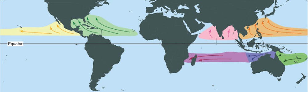
It’s helpful to start by visualizing where tropical storms develop in each ocean.
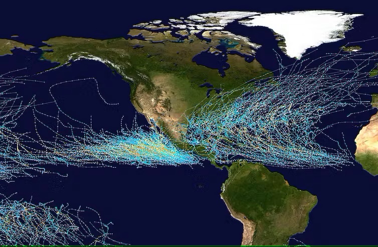
In the North Atlantic, tropical storms typically form over the warm waters off eastern Africa. As they move westward, they often hit Caribbean islands before making landfall on the U.S. Gulf Coast and Eastern Seaboard, or they curve off into the Atlantic.
Those tropical storms and hurricanes have caused over a trillion dollars in damage in the U.S. since 1981. That damage is expected to continue to increase. The reasons are both because warming global temperatures fuel stronger storms and because more people are building homes and businesses in harm’s way.
In the eastern North Pacific, tropical storms tend to form closer to land, between Mexico and Clipperton Island off Central America. They typically move to the northwest before turning westward out to sea. And they sometimes inundate the Mexican coast known as the Mexican Riviera. Longer-tracked Pacific storms that move into the central Pacific can affect shipping and hit Hawaii, as Hurricane Lane did in 2018.
The Atlantic gets the most attention, largely because it gets more damage with more people and property in the way. However, the Pacific tends to get more storms, especially during El Niño years. It’s often a seesaw pattern, with a busy year in one basin and a quieter season in the other.
El Niño creates a seesaw pattern
That seesaw pattern is largely driven by the El Niño-Southern Oscillation, or ENSO, which includes varying strengths of El Niño and its opposite, La Niña.
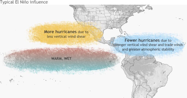
During El Niño, the trade winds that blow from east to west weaken. That allows warm ocean water to build up at the equator, west of South America. This causes a shift in the jet streams – strong upper-level winds – which affects rainfall and temperature patterns.
In the Atlantic Ocean, El Niño causes an area of low pressure in the upper atmosphere known as a trough and stronger upper-level winds. And that results in increased vertical wind shear, or a change in wind speed or direction with height in the atmosphere. Wind shear can tilt and stabilize storms, allowing fewer hurricanes to form.
Conversely, El Niño typically causes an upper-level ridge, or area of high pressure, and decreased vertical wind shear in the eastern North Pacific basin. In this region, El Niño often results in an active hurricane season.
La Niña is the opposite
La Niña – El Niño’s opposite, with cooler water in the tropical Pacific – reverses this pattern. The record 2020 and destructive 2021 Atlantic hurricane seasons were both during strong La Niña years.
On longer time scales, the Atlantic Multidecadal Oscillation (AMO), a fluctuation of North Atlantic sea surface temperatures, affects hurricane activity in cycles that span several decades. The AMO’s current warm phase, which began in 1995, has hosted seven of the 10 busiest Atlantic hurricane seasons. Hurricane activity often lessens in a cool phase of the AMO, during which the Atlantic is on average about one degree Fahrenheit (0.6 Celsius) cooler.
Who faces the greatest risk in the Pacific?
El Niño also changes who is at risk in the Pacific.
During El Niño events, storms in the eastern North Pacific tend to form farther to the west. With these events, the environmental conditions in the western portion of the basin tend to become more conducive than normal to tropical cyclones. For example, they have reduced environmental vertical wind shear and warmer ocean temperatures. That places Hawaii and the central Pacific at greater risk from damaging storms than normal.
The highly destructive Hurricanes Manuel in 2013 and Willa in 2018 show the immense impact Pacific storms can have in the region. Both triggered widespread flooding and mudslides in Mexico. Together, they led to over 125 deaths. In Hawaii, Hurricane Iniki’s storm surge and winds in 1992 destroyed over 1,400 homes on Kauai and damaged thousands more.
El Niño years also increase the viability of storms affecting the southwestern U.S. In 1997, multiple storms affected California and Arizona. That includes some that moved into the region after landfall in Mexico. Famously, in 2014, rough surf and swells associated with Hurricane Marie caused over $16 million in damage at the Port of Long Beach.
Why 2023 hurricane forecast is so uncertain
Forecasting the 2023 hurricane seasons is proving to be challenging for another reason: The Atlantic has abnormally warm sea surface temperatures this year. Those warm temperatures can power hurricanes … if storms are able to form.
Will the warm waters of the Atlantic overcome the unfavorable conditions brought by the El Niño? We’ll soon know.
The eastern Pacific hurricane season started May 15, and the Atlantic season starts June 1, with both running through November 30.
In its 2023 Atlantic hurricane outlook released in late May, NOAA forecast 12 to 17 named storms, five to nine hurricanes and one to four major hurricanes. In the eastern Pacific, NOAA forecasts 14 to 20 named storms, seven to 11 hurricanes and four to eight major hurricanes. For the central Pacific, including Hawaii, NOAA’s forecast includes four to seven cyclones, also above or close to average.
1st storm of the year in the Atlantic
Surprisingly, the Atlantic has already seen its first storm of the year. A storm in January was recently classified as a subtropical cyclone. This is rare. Our research shows the median date of the first named tropical cyclone is May 30 in the Pacific and June 20 in the Atlantic. Although Atlantic storms have been occurring, on average, earlier each year. We should expect the next named Atlantic and Pacific storms – Arlene and Adrian, respectively – in the coming weeks.
This article was updated May 25, 2023, with the central Pacific forecast.![]()
Kelsey Ellis, Associate Professor of Geography, University of Tennessee and Nicholas Grondin, Recent PhD Graduate in Geography, University of Tennessee.
This article is republished from The Conversation under a Creative Commons license. Read the original article.
Bottom line: The 2023 hurricane forecast is out! Due to El Niño, forecasters are calling for a busy Pacific basin and a quieter season in the Atlantic.
Read more: 2023 Atlantic hurricane outlook and list of names
Like what you read?
Subscribe and receive daily news delivered to your inbox.
More from
EarthSky Voices


