NOAA’s 14th annual Arctic Report Card, released December 10, 2019, recounts the numerous ways that climate change continued to disrupt the polar region during 2019, with near-record high air and ocean temperatures, a massive melt of the Greenland ice sheet, record low sea-ice extents, and major shifts in the distribution of commercially valuable marine species.
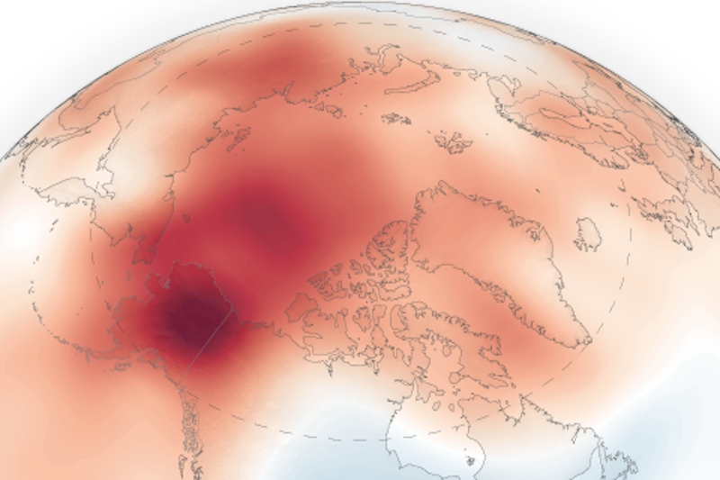
In 2019, surface temperatures were the second-warmest on record, continuing a string of 6 years that have been warmer than all other periods in the historic record dating back to 1900. Full story.
At gateways to the Arctic, northern fish are retreating
As Arctic waters warm, fish and marine mammals are migrating in search of their preferred habitats and food sources. In both the Bering and Barents Seas, Arctic fish are retreating, while more southern species are expanding northward. Full story.
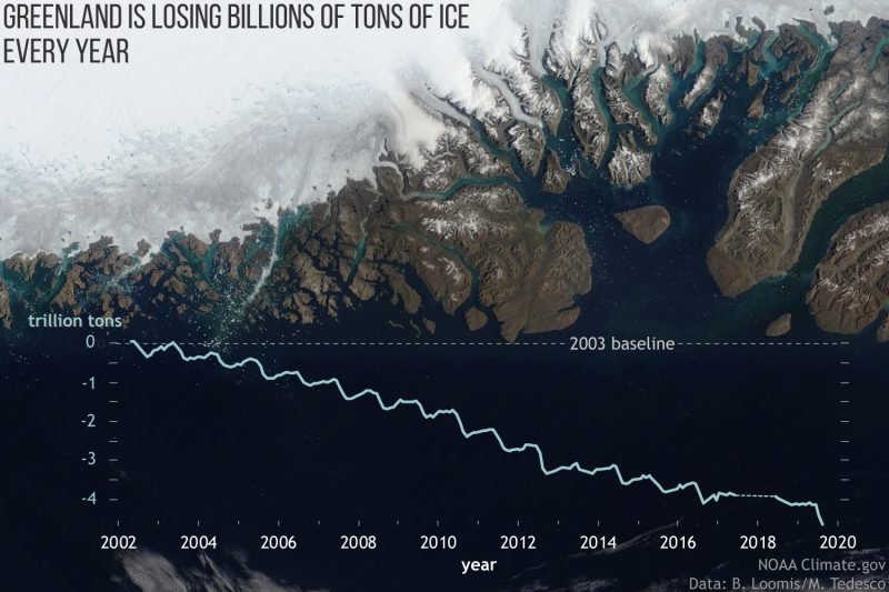
The Greenland Ice Sheet’s 2019 melt season rivaled record for area and duration
The Greenland Ice Sheet contains enough stored water to raise sea level by more than 24 feet (7.2 meters) as it melts. How fast that will occur is one of the big unknowns for predicting the pace of sea level rise over the rest of the century. The 2019 melt season on Greenland rivaled 2012’s record-melt year. Full story.
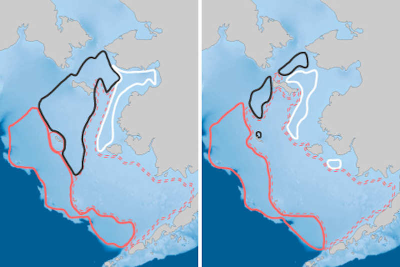
Less than 1% of Arctic ice has survived 4 or more summers
One consequence of the region’s dramatic warming trend is that Arctic sea ice doesn’t last as long as it used to. The proportion of old, thick ice in the Arctic’s winter maximum ice pack has dropped from more than a third in the mid-1980s to barely just 1% today. Full story.
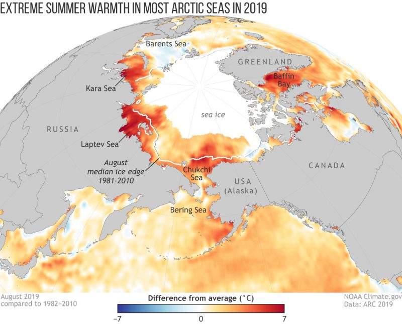
As sea ice disappears, Arctic seas are experiencing extreme summer warmth
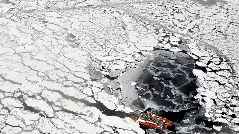
Like the air, the waters of the Arctic are warming, triggering a feedback loop in which sea ice melts, exposing more water to sunlight, leading to more warming. The warmth in summer can be extreme, as shallow coastal areas that were historically covered with sunlight-reflecting ice and snow are now open water. Full story.Two Canadian Coast Guard ships tie up to ice in the Arctic Ocean on September 5, 2019. The two ships were taking part in a multi-year, multi-agency Arctic survey to map the Arctic continental shelf. Image via Patrick Kelley/ U.S. Coast Guard.
Bottom line: NOAA’s 2019 Arctic Report Card reports near-record high air and ocean temperatures, a massive melt of the Greenland ice sheet, record low sea-ice extents, and major shifts in the distribution of commercially valuable marine species.
The EarthSky team has a blast bringing you daily updates on your cosmos and world. We love your photos and welcome your news tips. Earth, Space, Sun, Human, Tonight. Since 1994.
Like what you read? Subscribe and receive daily news delivered to your inbox.
Thank you! Your submission has been received!
Oops! Something went wrong while submitting the form.
If EarthSky has ever helped you discover something new, prepare for an eclipse, spot a planet, or simply inspired a moment of wonder, today is the perfect day to give back. Your donation helps keep trusted science news, expert night sky guides, and independent science journalism free for everyone.
Please help keep EarthSky going by donating today!
Please help keep
EarthSky going!
If you've already donated, we apologize for the popup and greatly appreciate your support.