


Tornadoes, large hail and damaging winds are possible in parts of the U.S. Midwest today, June 17, with the Storm Prediction Center forecasting a moderate risk of severe weather. Meanwhile, what might soon become Tropical Storm Arthur is expected to bring heavy rain and possible flash floods across the Gulf Coast, especially southern Texas.
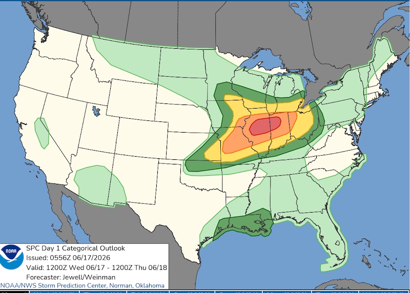
Wednesday’s severe weather
An outbreak of storms capable of producing damaging wind gusts of more than 75 miles per hour (120 kilometers per hour), hail larger than 2 inches (5 cm) in diameter and tornadoes as strong as EF3 on the Enhanced Fujita Scale is forecast for parts of Illinois and Indiana Wednesday.
A moderate risk (level 4 out of 5) for severe weather includes the cities of Springfield and Peoria, Illinois; Lafayette in Indiana; and approximately 2 million other people. A moderate risk indicates a higher likelihood that many storms will become severe, producing damaging wind gusts, large hail and intense tornadoes.
While all eyes will be watching the area of moderate risk, a level 3 enhanced risk also covers regions containing more than 13 million people. That includes those in the cities of Chicago, Illinois; Indianapolis and Fort Wayne, Indiana; and St. Louis, Missouri.
The Storm Prediction Center is expecting a volatile environment to develop. That’s thanks to a quick-moving clipper (a low-pressure system with a cold front and a warm front that moves south from west-central Canada) paired with warm, humid air at the surface, and favorable winds in the mid- and upper-levels of the atmosphere.
Storms are likely to develop during the first part of the day. But the most-likely timeframe for devastating severe weather is expected to arrive by early to mid-afternoon. The strongest storms, with the greatest chance to produce large hail and significant tornadoes, will occur near the conjunction of the cold front and warm front near the center of the low-pressure region, often called the triple point. More storms are expected to develop along the cold front into Kansas and Missouri, before the threats shift east toward Kentucky and the Mid-Atlantic overnight and into Thursday.
Gulf coast heavy rain
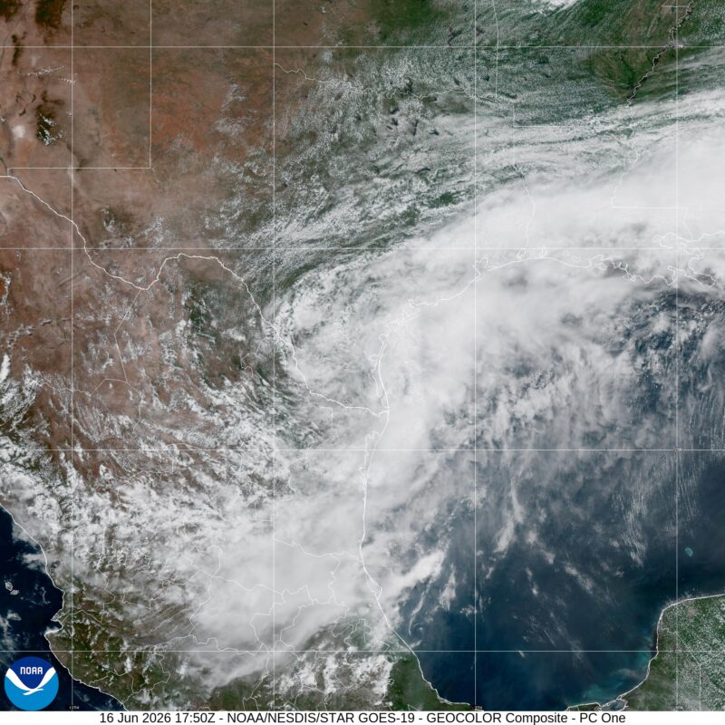
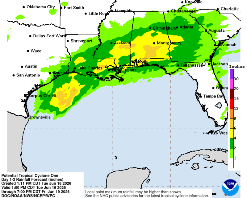
A developing tropical system dubbed Potential Tropical Cyclone One by the National Hurricane Center is bringing heavy rain along the Gulf coast. That’s causing more flash floods across an area that has already received inches of rain.
A potential tropical cyclone is a low-pressure region that doesn’t have tropical characteristics yet, but is expected to impact land as a tropical system within a matter of days. By designating a potential tropical cyclone, the National Hurricane Center can put out a forecast cone as well as watches and advisories, giving communities in the path of the system time to prepare.
Currently sitting southwest of Corpus Christi, the region of low-pressure is expected to move into the Gulf in the coming days and briefly become Tropical Storm Arthur. While Arthur will likely stay a weaker tropical storm, it will create dangerous and life-threatening flash flooding across the Gulf Coast. More than 7 inches (17 cm) of rain is forecast across parts of Texas, Louisiana, Mississippi, Alabama and Florida through Friday.
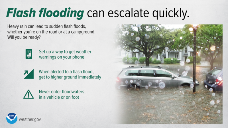
Staying safe during flash flooding
Flash flooding is aptly named; it can truly happen in a flash. Heavy rain can quickly inundate roads, cut off access to emergency services or businesses and sweep humans and vehicles away. It only takes 6 inches (15 cm) of rushing water to take a human off their feet, and 12 inches (30 cm) for most cars to be swept off the road.
This is why you should never drive through a flooded road, as you can’t see how deep the water is and you can’t see if the water has damaged the road, or completely washed it away.
You also need to seek higher ground during flash flooding, as water levels can quickly change. Because flash flooding can happen quickly, your phone will trigger a Wireless Emergency Alert (WEA) when your local National Weather Service office issues a Flash Flood Warning for your location. When these warnings are issued, take them seriously; avoid the flooded areas, move to higher ground and never try to drive or walk through the flood. A Wireless Emergency Alert will also trigger for a tornado warning.
Bottom Line: Tornadoes, large hail and damaging winds are expected in the U.S. Midwest on Wednesday, while a developing tropical system could bring flash floods across the Gulf Coast.
Read more: How cities can change the weather during storms
Read more: Cloud shapes are a useful tool for predicting weather
Like what you read?
Subscribe and receive daily news delivered to your inbox.
More from
Rachel Duensing


