


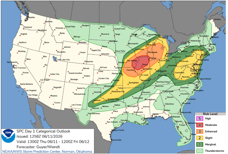
Update: On Thursday morning, NOAA updated the threat of severe weather in northern Illinois and surrounding areas to a level 4 out of 5. The update for moderate risk is because conditions are right for widespread and intense damaging winds, large hail and tornadoes. The tornadoes could be as strong as EF3. This region of the Midwest should expect two rounds of severe weather today, one this morning and one late afternoon and early evening.
Another round of severe weather is likely today, June 11, 2026, for the upper Midwest. The greatest threat for severe storms, including strong winds, hail and possible tornadoes, is in the afternoon and evening. The Storm Prediction Center said:
Strong to severe thunderstorm development, including one or two organizing clusters, will probably be accompanied by the potential for large hail, damaging wind gusts and perhaps a couple of strong tornadoes in a corridor across the Midwest into Great Lakes region Thursday through Thursday night.
Yesterday, a line of storms with strong winds passed through Wisconsin and Illinois, causing a lot of tree damage and leaving hundreds of thousands without power. There were also a few tornadoes, including this one in Unionville, Missouri.
Severe weather on Thursday
The Enhanced Risk for severe weather on Thursday includes Milwaukee and Madison in Wisconsin, Chicago, Rockford and Springfield in Illinois, Grand Rapids in Michigan and Hannibal in Missouri.
Severe storms are expected to bring destructive wind, strong tornadoes and large hail. Warm and humid conditions are in place across the upper Midwest and the Great Lakes region today. So as the cold front continues moving east, storms should develop by late morning before moving east with the front. As on Wednesday, the more isolated storms and supercells have the greatest risk for strong tornadoes and large hail, but storms will eventually start to “bow” out, supporting more of a damaging wind threat. Tornadoes are still possible.
While the worst of the weather will again be focused in the upper Midwest and Great Lakes, severe storms are still possible from Oklahoma out toward the Mid-Atlantic. There is also a risk for severe weather Friday from eastern Kentucky and western Virginia up through western New York. Damaging wind gusts and large hail are the most likely threats.
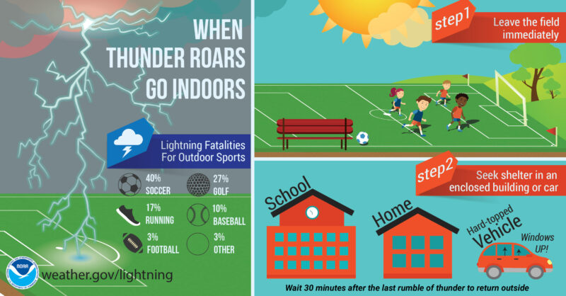
Outdoor storm safety
As we get closer to the beginning of summer, many children are out of school, and families may be planning vacations or other outdoor activities. Especially if your plans take you outside, it’s important to have a severe weather plan in place before the weather gets bad!
First is to make sure you’re staying up to date with the forecast. Check in with the trusted, local meteorologists for the area as well as the National Weather Service. This is a great way not only to plan your trip, but also to stay ahead of whatever weather will impact you.
If severe weather is in the forecast, know the best ways to get important warnings. Tornado warnings and flash flood warnings will automatically sound on your phone, as will severe thunderstorm warnings that are particularly dangerous. It’s also vital to have a weather radio programmed for your location (or the location where you will be traveling) as these radios are designed to be loud and wake you up in the middle of the night or alert you from another room.
Also make sure you know where your safe space is. No place outside is safe during a thunderstorm. During a storm, get inside the closest enclosed building or vehicle with the windows rolled up and wait out the storm. But during a tornado, do not shelter in a car.
You can find more safety tips here for when you’re planning your summer activities.
Bottom line: Severe weather is expected Thursday across the Midwest and Great Lakes region. Tornadoes, destructive wind and large hail are possible.
Read more: Cloud shapes are a useful tool for predicting weather
Read more: Be a storm spotter and help during severe weather
Like what you read?
Subscribe and receive daily news delivered to your inbox.
More from
Rachel Duensing


