


Hurricane Gabrielle strengthens to Category 4
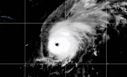
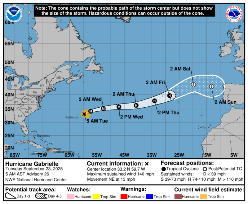
As of 9 UTC on September 23, 2025, Hurricane Gabrielle has strengthened into a Category 4 storm, with maximum sustained winds near 140 mph (225 kph). It’s currently about 330 miles (530 km) northeast of Bermuda, and moving northeastward at near 13 mph (21 kph). According to the National Hurricane Center, Gabrielle is expected to speed up on this path through Thursday, and those in the Azores should monitor its progress.
Gabrielle broke out as a tropical storm on Wednesday, September 17. This came after 20 days of no named systems in the tropical Atlantic Ocean, a period that WPLG-TV hurricane specialist Michael Lowry called “an unprecedented dry spell” for Atlantic hurricanes. Gabrielle then strengthened into a hurricane on Sunday, September 21, before escalating to a major Category 4 hurricane on Monday evening.
Factors affecting Hurricane Gabrielle’s strength
When it formed, Gabrielle did not look impressive on satellite imagery. While that has now changed since it became a hurricane, early in its life it had been fighting wind shear, which was trying to tear it apart. In addition, dry air and Saharan dust have been wrapping into it, cutting off necessary moisture. These factors have lessened, allowing Gabrielle to continue strengthening in the coming days.
Fortunately, forecasters don’t expect Gabrielle to directly impact land for a number of days. However, the storm could move near, or over, the Azores by Friday. Gabrielle will have weakened into a tropical storm by this point. But rough water and strong winds are still possible as the storm moves through.
We don’t expect any impacts to the United States or Canada. But Bermuda was also warned of indirect impacts. While Gabrielle passed more than 240 miles (386 km) from the island nation, the Bermuda Weather Service warned of strong winds and high swells with a risk for rip currents as the hurricane passed by Monday into Tuesday.
The tropical cyclone drought
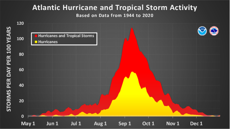
Gabrielle is just the 7th named storm of the Atlantic season, and only the second hurricane. On average, our 7th storm forms by September 3, and our second hurricane forms by August 26th. So, if it seems as if the Atlantic Hurricane season has been quiet, it’s because it has.
Tropical Storm Fernand dissipated back on August 28, leaving a 20-day stretch until Gabrielle formed. According to Philip Klotzbach of Colorado State University, since 1940 only 1992 and 2025 have had no new named storms from August 24 through September 16.
1992 was notable for a number of reasons. It was a below-normal season with only six named storms, and one sub-tropical storm (which at the time was not named). Of the six named storms, four became hurricanes. One was the infamous Hurricane Andrew which made landfall near Miami, Florida, as a Category 5. Andrew was the costliest hurricane for the United States until Hurricane Katrina in 2005.
The 1992 hurricane season is a stark reminder that even if a season is less-active than average, one storm is all it takes to cause devastation.
Why has 2025 been so quiet?
With all that being said, why has 2025 so far seen a quieter hurricane season? Again, referencing Klotzbach and the researchers at Colorado State University, high pressure across the Atlantic and dry air have played a role. Tropical cyclones need warm water, low wind shear and warm, moist air to properly develop. High pressure typically leads to calm, dry weather.
So the stronger-than-normal Atlantic high pressure has played a role in drier air across the main development region of the tropical Atlantic Ocean. More dry air usually means less development.
But another atmospheric feature was also likely keeping tropical development at bay. And that’s something called a tropical upper-tropospheric trough (TUTT). While it sounds complicated, basically this feature can bring down drier air from higher latitudes and also create more wind shear. Both can limit tropical storm development.
There’s also been less rain over west Africa during their monsoon season. The rain and storms over that part of the continent often move east to west into the Atlantic. They can become tropical waves, the beginning of tropical systems. So, if we don’t have those waves coming off Africa, there’s less likelihood of tropical development in the Atlantic.
After Hurricane Gabrielle: The rest of the season
While we were enjoying a break from any tropical troubles, there are indicators that our season could still be active. Forecasters say the strong high pressures over the Atlantic are expected to weaken slightly. Wind shear could be starting to weaken as well. These would all help tropical waves to develop.
In fact, the National Hurricane Center has outlined two tropical waves behind Gabrielle for possible tropical development. The pair of waves have low and moderate odds for development within the next week.
While the hurricane season usually peaks at September 10, tropical activity peaks from mid-August through mid-October. The Atlantic hurricane season runs through November 30.
Bottom line: Hurricane Gabrielle has strengthened into a Category 4 storm. It’s about 330 miles (530 km) northeast of Bermuda, and moving northeastward at near 13 mph (21 kph). Gabrielle is expected to speed up on this path through Thursday, and those in the Azores should monitor its progress.
Like what you read?
Subscribe and receive daily news delivered to your inbox.
More from
Rachel Duensing


