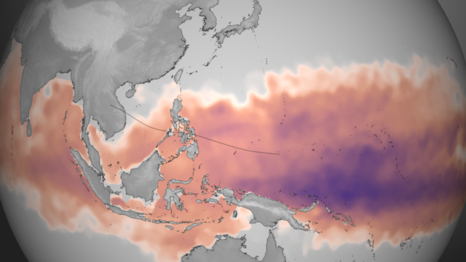
View larger. | According to NOAA, deep warm water fueled Haiyan’s intensification. Plotted here is the average Tropical Cyclone Heat Potential product for October 28 – November 3, 2013, taken directly from NOAA View. This dataset, developed by NOAA/AOML, shows the total amount of heat energy available for [a] storm to absorb, not just on the surface, but integrated through the water column. Deeper, warmer pools of water are colored purple, though any region colored from pink to purple has sufficient energy to fuel storm intensification. Image and caption via NOAA Visualization Laboratory.The U.S. Navy’s Joint Typhoon Warning Center said earlier this week it expected Super Typhoon Haiyan to weaken as it crossed the ocean to the Philippines. Instead, Haiyan intensified and accelerated as it moved closer to Philippines and ultimately made landfall today. Why?
NOAA said that “ideal” environmental conditions for intensification – namely low wind shear and warm ocean temperatures – exist in the Pacific now. Those conditions allowed Haiyan to grow into one of the strongest – perhaps the strongest – storm ever recorded.
Deborah Byrd (asteroid 3505 Byrd) helps edit EarthSky.org and is a frequent host of EarthSky videos. Deborah created the EarthSky radio series in 1991 and founded EarthSky.org in 1994. Prior to that, she had worked for the University of Texas McDonald Observatory since 1976, and created and produced their Star Date radio series. She has won a galaxy of awards from the broadcasting and science communities, including having an asteroid named in her honor in 1990, a Public Service Award from the National Science Board in 2003, and the Education Prize from the American Astronomical Society in 2020. A science communicator and educator since 1976, Byrd believes in science as a force for good in the world and a vital tool for the 21st century. "Being an EarthSky editor is like hosting a big global party for cool nature-lovers," she says.
Like what you read? Subscribe and receive daily news delivered to your inbox.
Thank you! Your submission has been received!
Oops! Something went wrong while submitting the form.
If EarthSky has ever helped you discover something new, prepare for an eclipse, spot a planet, or simply inspired a moment of wonder, today is the perfect day to give back. Your donation helps keep trusted science news, expert night sky guides, and independent science journalism free for everyone.
Please help keep EarthSky going by donating today!
Please help keep
EarthSky going!
If you've already donated, we apologize for the popup and greatly appreciate your support.