


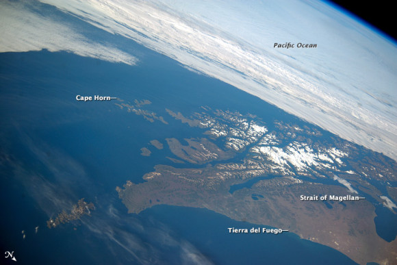
This panoramic image from the International Space Station (ISS) captures Tierra del Fuego and Cape Horn, the southernmost tip of South America. The Atlantic Ocean is in the foreground and the Pacific Ocean spreads across the top of the image. Crews on the ISS seldom see Cape Horn in such clear weather. Shortly after this image was taken, the cloud mass approaching from the Pacific Ocean completely obscured the landscape from view. In this stormy part of the world, ships avoid the heavy seas around Cape Horn and use the protected Strait of Magellan on the inshore end of Tierra del Fuego.
A small, white ice field on the highest parts of Tierra del Fuego includes Mount Darwin, situated within Chile’s Agostini National Park. The ice field was much larger during the geologically recent ice ages, covering an area greater than the land shown in this view. The heavily indented shape of the fjord coastline and the lake depressions (image center and lower right) were carved by the downhill movement of these now-vanished glaciers.
Like what you read?
Subscribe and receive daily news delivered to your inbox.
More from
Editors of EarthSky


