


July 4, 2013. 7:30 p.m. EDT (2330 UTC). An extreme weather pattern for parts of the U.S. is expected to continue to stick around for the next several days. There is a large upper level trough of low pressure stalled across the central U.S., and two areas of high pressure – one in the U.S. West and another across Bermuda – have been holding in place for the past several days. With no movement, this large trough has been unable to push out of the country, and this blocking pattern has brought tropical moisture streaming into the U.S. Southeast and major heat across the U.S. Southwest.
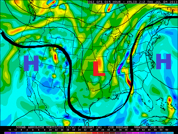

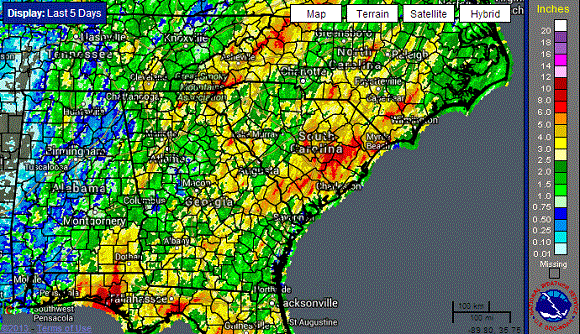
The jet stream – a fast moving river of moving air – acts as a divider for cool air to the north and warm, moist air to the south. In this past week, the jet stream has dug deeply into the central U.S. A deep trough in the United States in early July is rare. The jet stream is typically oriented across Canada at this time of the year. The jet is oriented in a way that it is literally grabbing deep, tropical moisture from the Gulf of Mexico and spreading it northwards into the Southeast. Rainfall totals over the past five days have been impressive in several spots across the Southeast. Tallahassee, Florida recorded a daily record rainfall for July 3, 2013 with 2.53 inches of rain, breaking the old record of 2.23 inches recorded in 1994 when Tropical Storm Alberto moved ashore. Panama City recorded 6.28 inches of rain on July 3, and more rain is on the way. Locations along the Appalachian Mountains have also recorded heavy rainfall, with totals exceeding five inches. The ground was already saturated prior to this system developing over the Southeast.
You can check out the water vapor imagery of North America showing the jet stream digging south and pushing plenty of gulf moisture into the southeastern United States:
Heavy rain that moves over the same spots can create flash flooding. It is important that you never drive into flooded roads. This video is a perfect example of what you should never do if you get near flooded roads. Always turn around and don’t drown! Warning: Video contains inappropriate language.

Can we link climate change with the current unusual weather pattern? According to a report released on October 2012 by the National Oceanic and Atmospheric Administration (NOAA), the warming of the Arctic and the overall planet can influence the orientation of the jet stream. According to the report:
The effects of Arctic amplification will increase as more summer ice retreats over coming decades. Enhanced warming of the Arctic affects the jet stream by slowing its west-to-east winds and by promoting larger north-south meanders in the flow. Predicting those meanders and where the weather associated with them will be located in any given year, however, remains a challenge.
The current weather occurring across North America is an example of what climate change can do to our jet stream over time. Can we directly blame climate change with this particular pattern? The answer is no. However, climate models and many studies show that unusual weather patterns such as this one will become more typical as ice continues to melt in the Arctic and as the climate continues to gradually warm. Studies will likely be conducted about this weather pattern to further investigate how climate change might or might not play a direct role in this particular weather pattern.
Bottom line: A large trough of low pressure stuck across the central United States for the next several days will bring heavy rains and flooding to the southeastern U.S. This weather pattern is very unusual for the month of July. It is important that everyone in the Southeast avoid flooded roads and monitor the weather for possible warnings and advisories as a stream of moisture continues to pour into the region through Sunday.
Like what you read?
Subscribe and receive daily news delivered to your inbox.
More from
Matt Daniel


