


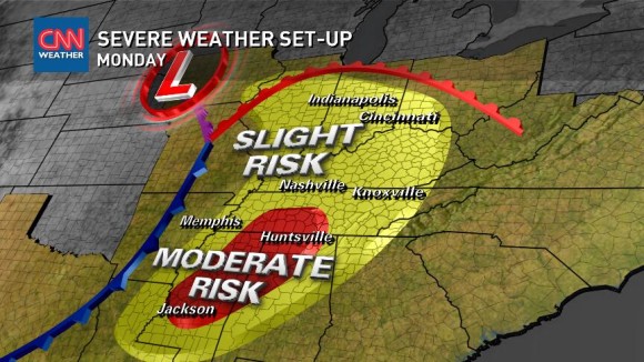
UPDATE APRIL 28, 2014 7 A.M. CDT (12 UTC): At least 12 people have died after tornadoes struck Arkansas and Oklahoma yesterday, and more severe weather is in the forecast for today. The severe weather forecast extends from northeastern Texas and northern Louisiana to southern Illinois on Monday. Millions in those areas can expect to see thunderstorms, high winds, hail and possibly tornados.
The video below is from Mayflower, Arkansas. Jordan Hamilton and Tyler Costantini captured the devastation in Mayflower on video, right after a tornado struck.
Best bests for information during severe weather outbreaks

WEEKEND STORY BEGINS HERE: Severe weather season for the United States typically comes in spring, and the U.S. has seen a very quiet storm season thus far. Things have changed, however, as we head into the next final days of April 2014, as a major storm system develops across the Central Plains. A multi-day and long-duration severe weather event has started this weekend and is expected to last through next Wednesday. Severe weather watches have already been issued in the Central Plains this morning (more info here). In the coming days, severe weather could impact not only the U.S. Central Plains, but also the Southeast U.S. Specific information on intensity and exact timing of the storms is still up in the air. The pattern looks volatile, though, and could bring some nasty weather across the southern portion of the United States for several days.
On Sunday, the atmosphere is expected to become more volatile as we go throughout the day. We are already seeing severe thunderstorm watches and warnings before the sun even rises. This is an indication of how strong of a storm system this is. Strong tornadoes, damaging winds, and large hail are expected for parts of the Central Plains and along the Mississippi River Valley. We have two days of moderate risks (Sunday/Monday) and the severe threat continues through Wednesday/Thursday.
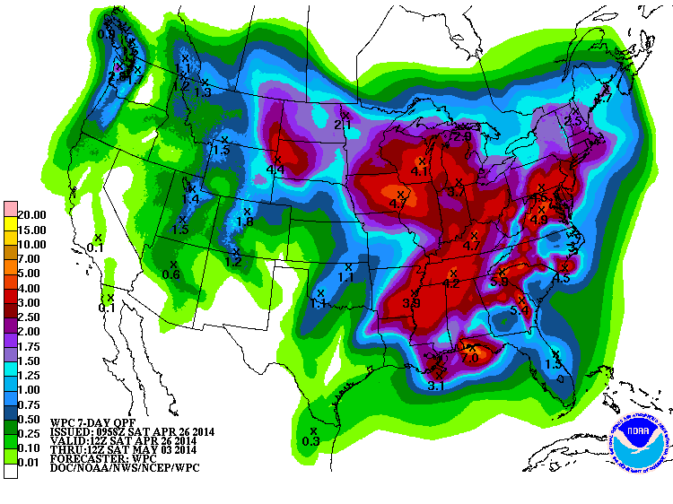
Another big story is the heavy rain that will be falling across the Southeast and Midwest. Flooding could be a huge problem in many areas.
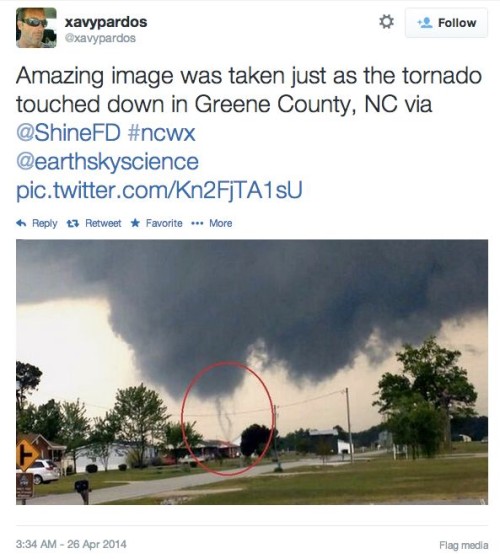
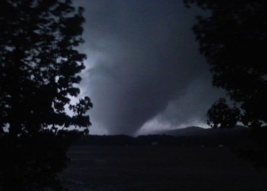
Severe weather has also begun elsewhere, via a different storm system. North Carolina experienced at least three tornados on Friday, April 25, which damaged hundreds of homes and sent at least 15 people to the hospital with injuries, according to Accuweather. The image below is one of the April 25 North Carolina tornados. That storm system has now pushed out to sea.
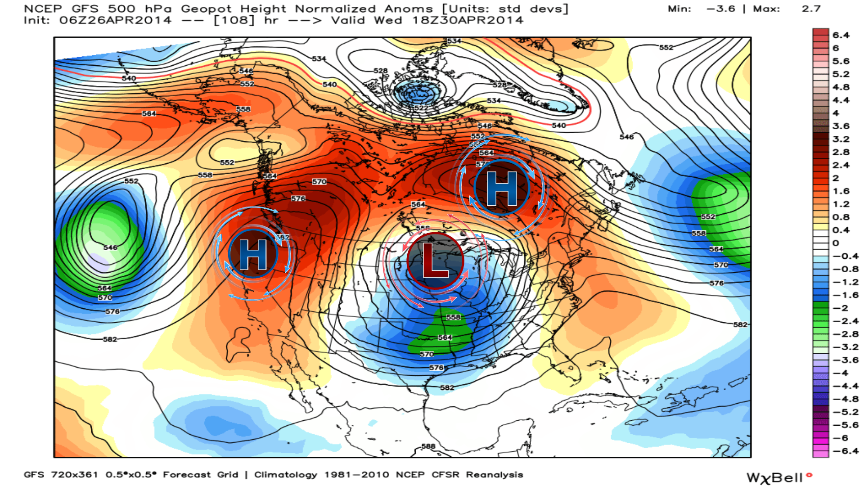
One of the crazy aspects of the central U.S. storm system is the weather pattern itself, as shown in the image above. High pressure to the west and east of the storm is preventing it from pushing out quickly. A slow moving storm system means a long duration of severe storms and heavy rain across the same areas. Typically, these systems are relatively quick and push out in a couple of days as they move from west to east. That is not the case with this storm system.
Meteorologists look at the weather in several angles to predict a potential severe weather outbreak. They don’t only look at surface temperatures, dew points, and rainfall coverage for a certain point. They also look at all layers of the atmosphere. As you go up from the surface to around 5,000 feet into the air, meteorologists look at how the winds change with height.
With a very strong area of low pressure likely to form across the Central Plains, it looks as if we will see plenty of wind shear. Wind shear is one mechanism meteorologists look at to determine if storms can rotate and sustain themselves. The more shear you see, the stronger the storms could become.
Another ingredient meteorologists look at is instability, or the fuel you need to strengthen storms. The warmer, more humid air mass will bring about more instability, or fuel, for thunderstorms. Because of this fact, this energy can help create a lot of juice for thunderstorms to grow in size and intensity.
When you combine shear and instability together, you can have two big ingredients for severe weather. Of course, you also need moisture and a lifting mechanism. With that in mind, getting the perfect ingredients together are difficult to have sometimes. For instance, the Storm Prediction Center still has uncertainty of exactly where the strongest storms could develop across the Plains. It all depends on if the moisture, instability, and shear meet at a certain point and time. If they get a better consensus of that timing, then they might be inclined to enhance the severe weather risk for that particular area.
Yes, weather forecasting can be complicated.
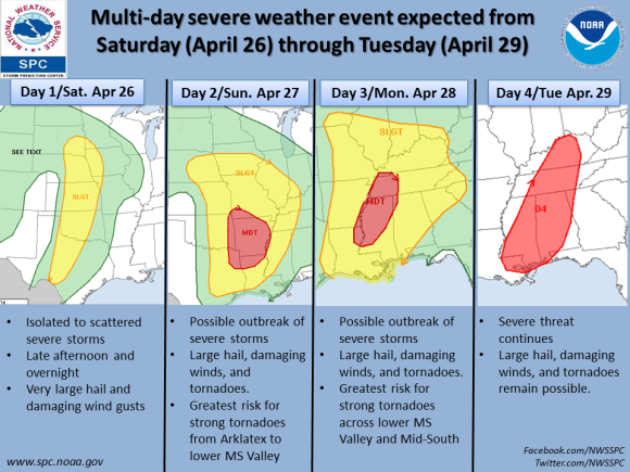
The severe weather outbreak will start in the U.S. Central Plains this weekend and push eastward with time. The main threats will be strong tornadoes, damaging winds over 60 miles per hour, and very large hail. The Storm Prediction Center mentioned in their Day 2 outlook for Sunday that they could upgrade the moderate risk into a high risk if the conditions continue to appear favorable.
It is important that everyone in the risk areas take every warning seriously and have plans on where to go if severe weather approaches you. The threat for strong tornadoes increases Sunday and Monday ahead of the system. Never rely on one system. If you only depend on your weather app, you might want to reconsider tuning into your local news, your local National Weather Service, and to social media.
Another big and concerning part of this long and extended potential outbreak of severe thunderstorms is the flooding potential. With the system slowly pushing to the east, many areas could pick up significant amounts of rainfall. The U.S. Southeast has already seen above average rainfall thanks to previous storms in the area this past month. The models are actually showing rainfall totals over 3-5 inches in many spots. If we see localized areas of more than 5 inches, which is very possible, then we could see a flash flooding event.
The good news about the heavy rainfall threat is that it could limit the fuel that intensifies thunderstorms. If it remains cloudy and rainy, storms could be slightly weaker. Once again, this is another issue that can complicate the forecast. If you don’t see severe storms, you might have to worry about the heavy rain potential.
Bottom line: At least a dozen people have died after tornadoes struck Arkansas and Oklahoma yesterday (April 27, 2014), and more severe weather is in the forecast for today. The severe weather forecast extends from northeastern Texas and northern Louisiana to southern Illinois on Monday. Millions in those areas can expect to see thunderstorms, high winds, hail and possibly tornados.
Like what you read?
Subscribe and receive daily news delivered to your inbox.
More from
Matt Daniel


