A significant and very strong storm system will develop on Christmas Day (December 25, 2012) across the eastern United States and will bring major problems across the region. For the Southeast United States, severe weather appears very likely with an increasing threat for long-lived, strong tornadoes and wind gusts that could exceed 70 miles per hour. All modes of severe weather appear likely in Louisiana, south/central Mississippi, south/central Alabama, Georgia, Florida, and Wednesday afternoon into South Carolina and North Carolina. Meanwhile, northwest of the area of low pressure, a major winter storm will evolve. Snowfall accumulations could easily reach 6+ inches across Oklahoma, Arkansas, southeast Missouri, southern Illinois, Indiana, and western Kentucky. Everyone in these locations should take precautions now and be weather ready on Christmas Day and on December 26, 2012.
Severe Weather Threat:
Two modes of severe weather likely across the Southeast:
– Squall line will likely develop along the cold front.
-Ahead of the squall line, discrete supercells could develop.
Main Threats:
-Strong, straight line winds in excess of 70 mph.
-Tornadoes appear likely, and some could be long-lived and stronger than EF-2 strength.
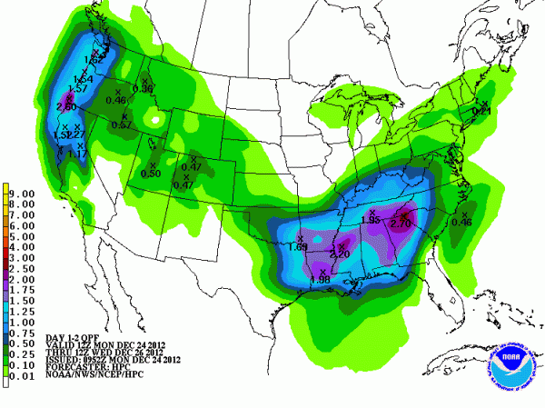
-Heavy rain of two to three inches possible across the Southeast could bring about isolated areas of flash flooding.

In the wintertime, instability is typically the value that is missing when it comes to strong storm systems. These dynamic storm systems typically have plenty of wind shear as they transport cold air southward. However, with this storm, instability is actually forecast to increase across the Southeast which mainly acts as fuel for the storms to develop and remain strong. Helicity values are extremely high and models are showing values around 350 TO 400 M2/S2. Helicity mainly indicates the spin in the atmosphere. Anything over 150 M2/S2 is considered significant and good for tornado development. There is a threat for substantial wind damage across the Southeast as a large squall line develops and pushes to the east. With the trough being negatively tilted and a strengthening area of low pressure, the ingredients are all coming together for a significant severe weather outbreak that will likely include strong tornadoes.
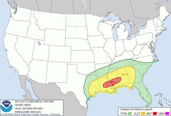
Here is the Day 2 outlook by the Storm Prediction Center:

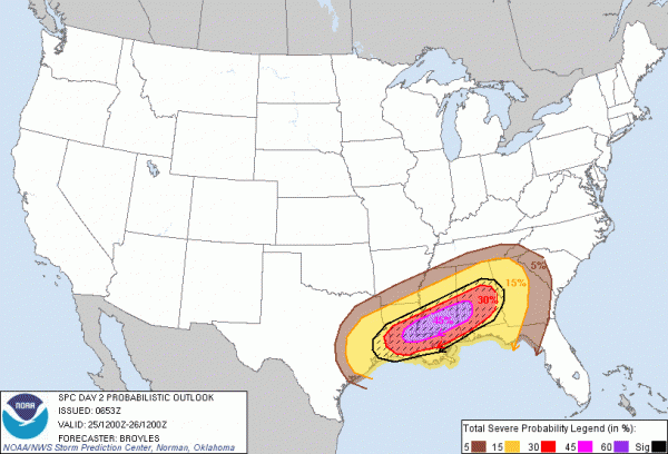
Here is the probabilities for severe weather for December 25, 2012:

In the image above, parts of eastern Louisiana, southern Mississippi, and southwest Alabama are in a 45% hatched area for severe weather. These probabilities simply show the probability of severe weather within 25 miles of a point. The hatched area indicates a 10% or greater probability of significant severe weather within 25 miles of a point. If you live in any of the highlighted areas, be weather aware.
Check list:
Since a large majority of the severe weather outbreak will occur at night, you need to make sure you have these things ready:
1) Make sure you have fresh batteries and a NOAA Weather Radio by your bed.
2) Sleep in a room in your house that is centered away from trees outside that could possibly fall over on the top of your house.
3) Download the iMap Weather Radio application for your phone or tablet. It is now available for Apple and Android products. It will notify you if warnings are issued in your area.
4) Tell your friends and family about the severe weather threat. Knowledge is power, and knowing can save lives.
5) Do you own a bike helmet? If you do, you should have one near you on Christmas Day/night. If you are in a tornado warning, go to your safe spot and wear the helmet. It really does save lives.
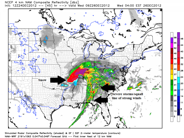
Here is an image below by the NAM model output showing a representation of what the radar could look like on Wednesday morning. It definitely indicates severe storms possible across the Southeast with heavy snow northwest of the low pressure system. Timing is still uncertain as the NAM model wants to slow this system down, whereas the GFS model indicates the storms pushing into the Southeast about six hours earlier. I think I am leaning towards the faster solution. Regardless, the setup is still there:

Winter aspect of this storm:

Meanwhile, heavy snow and cold air will follow behind this dynamic storm system. The National Weather Service offices in Oklahoma, Arkansas, Missouri, Indiana, and Illinois has already issued winter storm warnings across their area indicating that heavy snow will cause major problems for the roads. Snowfall totals could easily add up to 6 inches across many of the watch/warning areas listed above. visibility will be reduced, and motorists are urged to avoid driving out on the roads as treacherous conditions develop. Snow should begin falling by Christmas afternoon. The bright side: You get a white Christmas!
Bottom line: A very dynamic and dangerous storm is developing and will impact the central and eastern United States on Christmas and on December 26. The storm has two aspects: Winter and spring. North and west of the low, the winter aspect of this storm will produce heavy snow and bring about at least six inches of snow across Oklahoma, Arkansas, Missouri, Illinois, and Indiana. Meanwhile, the storm has a spring like setup as warm air from the Gulf will help spark severe weather across the Southeast with straight line winds and tornadoes as the main threat. Supercells could develop ahead of the main line of storms, and some of these tornadoes could be strong (greater than EF-2 intensity). Obviously, this is a less than ideal situation for Christmas Day. My best advice is to be weather ready and to notify your friends and family that live in these areas. With Christmas finally arriving, many people might not be aware of the developing weather situation as they stay home with friends and family. If you do not live in these areas but would like to help, share this post via social media. The more people know, the better. Stay safe!


