


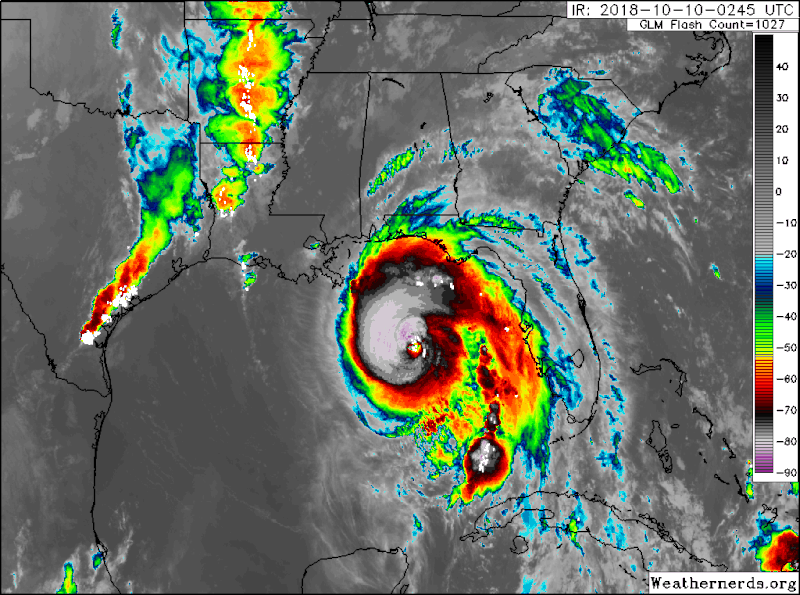
Hurricane Michael is due to make landfall in northern Florida today – Wedneday, October 10, 2018 – as a Category 4 storm. Previously, it had been expected to strengthen only to Category 3. Landfall will likely occur in Florida’s Panhandle. It is the area’s strongest hurricane in over a decade. The National Hurricane Center’s 4 a.m. EDT advisory on Wednesday said:
…EXTREMELY DANGEROUS CATEGORY 4 MICHAEL STRENGTHENS
FURTHER AS IT HEADS NORTHWARD TOWARD THE FLORIDA PANHANDLE…
…LIFE-THREATENING STORM SURGE…HURRICANE FORCE WINDS…AND HEAVY
RAINFALL EXPECTED ALONG THE NORTHEASTERN GULF COAST…SUMMARY OF 400 AM CDT…0900 UTC…INFORMATION
———————————————-
LOCATION…28.3N 86.5W
ABOUT 140 MI…225 KM SSW OF PANAMA CITY FLORIDA
ABOUT 130 MI…215 KM SW OF APALACHICOLA FLORIDA
MAXIMUM SUSTAINED WINDS…140 MPH…220 KM/H
PRESENT MOVEMENT…N OR 360 DEGREES AT 13 MPH…20 KM/H
MINIMUM CENTRAL PRESSURE…943 MB…27.85 INCHES
Multiple storm watches and warnings are in effect along the Gulf of Mexico coast.
Key messages from the National Hurricane Center are below. For updates on the storm, follow the National Hurricane Center on Twitter at @NHC_Atlantic.
Here are the 4 AM CDT Key Messages on #Michael pic.twitter.com/EzXC9XqIkC
— National Hurricane Center (@NHC_Atlantic) October 10, 2018
Update 4 am CDT Extremely dangerous category 4 Hurricane #Michael nearing the coast of the Florida panhandle. This is a life-threatening event for the northeastern portion of the Gulf Coast. Hourly updates will be provided at https://t.co/tW4KeGdBFb pic.twitter.com/SWmdKROpYU
— National Hurricane Center (@NHC_Atlantic) October 10, 2018
Hurricane force winds are expected to extend well inland over portions of the Florida Panhandle and portions of southeast Alabama and southwest Georgia as Michael moves inland, where hurricane warnings are in effect. pic.twitter.com/p9IrnFp86A
— National Hurricane Center (@NHC_Atlantic) October 10, 2018
A Storm Surge Warning remains in effect for much of the Florida Panhandle and Big Bend region, where life-threatening storm surge is expected today. Storm surge inundation could reach 9 to 13 feet above ground level between Tyndall Air Force Base and Keaton Beach FL @NHC_Surge pic.twitter.com/7GZU8Ceq3y
— National Hurricane Center (@NHC_Atlantic) October 10, 2018
Hurricane #Michael. In addition to the life-threatening storm surge and wind impacts, heavy rainfall is expected across a large portion of the southeastern U.S. along Michael's track. These heavy rains are expected to extend well inland. pic.twitter.com/cUlAtrFTDC
— National Hurricane Center (@NHC_Atlantic) October 10, 2018
Bottom line: Hurricane Michael is now a Category 4 storm, due to make landfall in northern Florida on Wednesday, October 10, 2018.
Like what you read?
Subscribe and receive daily news delivered to your inbox.
More from
Deborah Byrd


