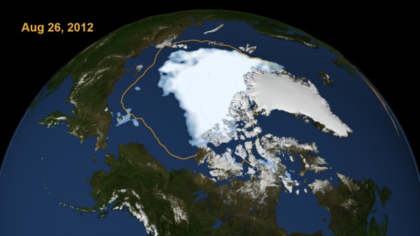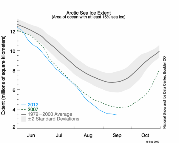
It is official. Arctic sea ice for the year 2012 is at the lowest levels ever recorded since record keeping began nearly three decades ago, when scientists began monitoring the rate of ice with satellite measurements. In fact, Arctic ice dropped to levels unseen since we began measurements by August 26, 2012 – earlier than expected – as ice extent dropped under 4 million square kilometers (1.54 million square miles). According to Climate Central, the amount of ice that has melted in the Arctic is roughly around the size of Alaska and Canada combined. Since August, sea ice extent has remained lower than its 2007 lowest point, which once held the record for the lowest sea ice extent in the Arctic. Scientists say we have now likely hit the low point of Arctic melting for the 2012 season. But, if the trend of melting sea ice in the Arctic summertime continues, which appears to be likely, we’ll see ice in the Arctic shrink in size each summer – sometimes more, sometimes less – perhaps reaching an even lower lowest point within the coming years.

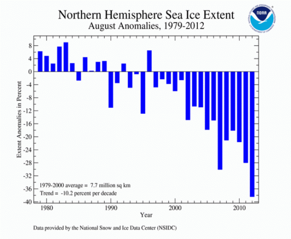
Overall, sea ice extent in the Arctic has been decreasing steadily throughout this past decade. In fact, the six lowest sea ice extents in the satellite record have occurred in the last six years (2007 to 2012). According to the National Snow & Ice Data Center, the rate of ice loss for August 2012 was 91,700 square kilometers (35,400 square miles) per day, the fastest observed for the month of August over the period of satellite observations. In comparison, August 2007, the same year that was once held the record for the lowest sea ice extent, ice was lost at a rate of 66,000 square kilometers per day. Arctic sea ice extent has been reduced by nearly 45% since the 1980s. The high northern latitudes generally are experiencing the warming climate globally more than the lower latitudes, where most of Earth’s people live.
The melting of the ice is expected to accelerate global warming. According to Peter Wadhams of Cambridge University, a professor who specializes in the Arctic:
The continental shelves of the Arctic are composed of offshore permafrost, frozen sediment left over from the last ice age. As the water warms the permafrost melts and releases huge quantities of trapped methane, a very powerful greenhouse gas so this will give a big boost to global warming.
The persistent loss of perennial ice cover – ice that survives the melt season – led to this year’s record summertime retreat. Unlike 2007, temperatures were not unusually warm in the Arctic this summer. In 2007, it was actually much warmer. We are losing the thick component of the ice cover. And if you lose the thick component of the ice cover, the ice in the summer becomes very vulnerable.
A post at Climate Central mentions that loss of ice in the Arctic could play a significant role in the weather patterns that will occur during the winter months in the Northern Hemisphere. According to Jennifer Francis, an atmospheric scientist at Rutgers University in New Jersey, the loss of sea ice is adding extra heat and energy not only into the ocean, but into the atmosphere. The jet stream – which acts like a river of strong winds at upper levels of the atmosphere, generally blowing from west to east across the northern mid-latitudes – may become amplified. A more amplified jet stream can lead to more extremes such as colder temperatures plunging further south. It is still uncertain as to how the melting in the Arctic directly affects our weather in the Northern Hemisphere. There are other factors that also play a significant role in regards to how cold our winters could get. For instance, scientists look at other weather patterns such as the ENSO (La Niña/El Niño, North Atlantic Oscillation, Arctic Oscillation, etc. Regardless, we’ll all be watching the weather, with scientists trying to explain it via the study of climate, and with speculation by ordinary citizens rampant, no doubt, as sea ice extent continues to shrink.

Bottom line: In 2012, Arctic sea ice extent is at the lowest levels ever recorded since we began monitoring ice extent via satellites three decades ago. The Arctic melting season starts in May and ends around the middle of September. We have likely hit the lowest point of Arctic sea ice for 2012. And it’s low indeed, with Arctic sea ice extent averaging 1.82 million square miles, 38.5 percent below the 1979 to 2000 average. From mid-September onward, sea ice typically begins to grow as the winter months approach and temperatures in the Arctic drop. Overall, the trend of melting sea ice in the Arctic continues in the Arctic. Scientists say it could accelerate greenhouse gas emissions down the road. Scientists were predicting an ice-free Arctic sometime in the 21st century. Some scientists now believe that, within five more years, we could see an ice-free Arctic during the summer months.


