


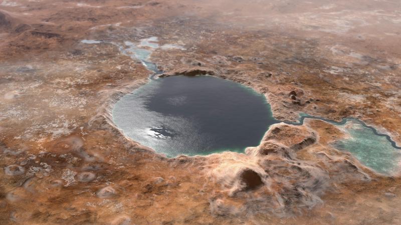
NASA’s Perseverance rover is looking for evidence of past Martian life in one of the best places possible: the ancient remains of a Martian lake, in Jezero Crater. Previously, orbiting spacecraft showed that the crater even contains a still-visible river delta. Now, images from the rover confirm the ancient lake and the river that once fed into it, as well as, surprisingly, flash floods.
The new peer-reviewed findings from the Perseverance mission team were published in the journal Science on October 7, 2021.
Delta provides clues about Martian lake
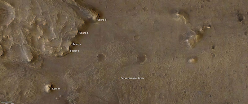
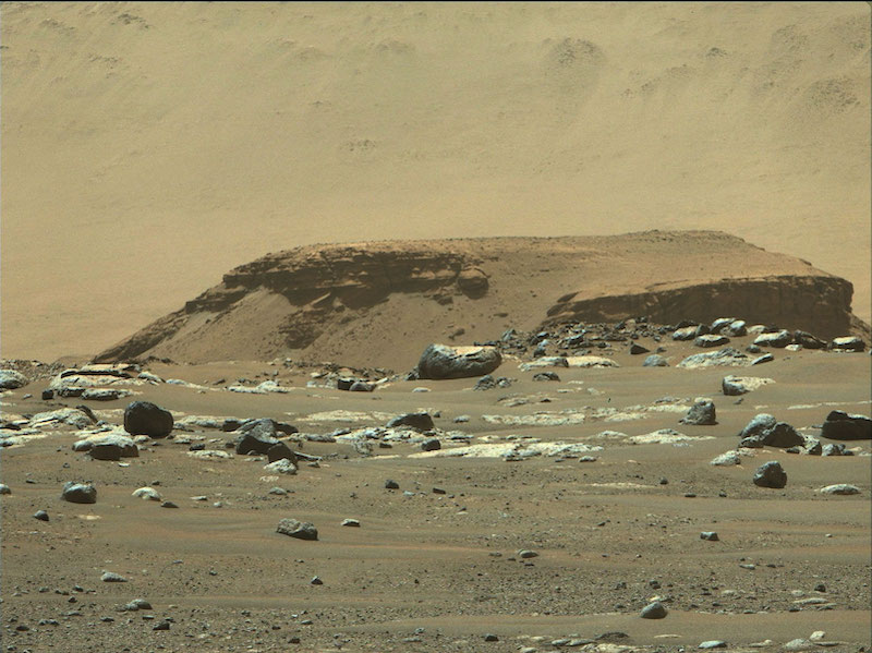
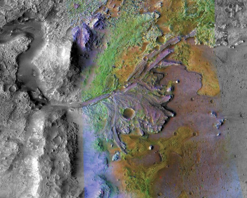
In particular, the delta itself provides many of the clues about past water in Jezero Crater. The rover took detailed images of the delta, which showed steep slopes called escarpments or scarps. The delta formed just like deltas on Earth, from accumulating sedimentary deposits. The images were taken by the rover’s left and right Mastcam-Z cameras as well as its Remote Micro-Imager (RMI), which is part of the SuperCam instrument.
Now, we know that not only was there a lake fed by a river, which created the delta, but there were also late-stage flash floods that carried large boulders into the delta.
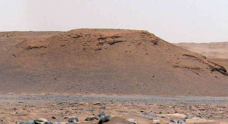
Kodiak outcrop
In addition, even more signs of ancient water came from a rock outcrop called Kodiak. The outcrop is about a mile from the rover’s current position, the same distance as the scarps. By examining images of the outcrop, mission scientists determined the timing of different geological deposits. The outcrop is now “broken off” from the main delta but was once closer to the southern edge of the delta.
The images show horizontal and inclined layering, just like that seen in deltas on Earth. Nicolas Mangold, lead author of the paper at the Laboratory of Planetology and Geodynamics (LPG) in France, commented on the importance of the findings, saying:
Never before has such well-preserved stratigraphy been visible on Mars. This is the key observation that enables us to once and for all confirm the presence of a lake and river delta at Jezero. Getting a better understanding of the hydrology months in advance of our arrival at the delta is going to pay big dividends down the road.
Unexpected boulders
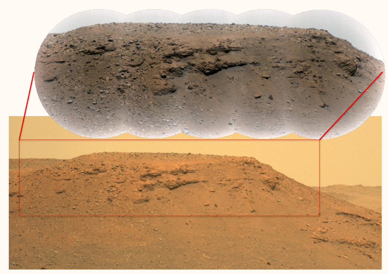
Prior to the Perseverance mission, scientists were already confident that Jezero Crater used to be a lake, and that the delta formation really was a delta. But now, Perseverance has confirmed both. That’s not all, however. The rover also spotted a surprise: boulders in places where they were not expected, residing in the scarps. More specifically, they are in the youngest and topmost layers of the delta. In fact, some of them probably weigh several tons. Mangold said:
We saw distinct layers in the scarps containing boulders up to 5 feet (1.5 meters) across that we knew had no business being there.
So what were they doing there?
Flash floods
According to the mission scientists, this is evidence of past flash floods. Basically, the slower river feeding the delta couldn’t have moved those boulders; faster-moving floods would have been required. Indeed, some of the boulders had been transported tens of miles. The speed of the water torrents is estimated to have been from 4 to 20 mph (6 to 30 kph). Benjamin Weiss at MIT added:
You need energetic flood conditions to carry rocks that big and heavy. It’s a special thing that may be indicative of a fundamental change in the local hydrology or perhaps the regional climate on Mars.
A fluctuating lake
Furthermore, the new evidence supports the previous thinking by scientists that the lake filled the crater up to the rim. However, it also indicates that the water levels fluctuated over time later in the history of the lake. By that time, the levels were about 330 feet (100 meters) below their highest levels. Ultimately, as with the rest of the planet, the lake dried out completely.
Sanjeev Gupta from Imperial College, London, a co-author, said:
A better understanding of Jezero’s delta is a key to understanding the change in hydrology for the area. And it could potentially provide valuable insights into why the entire planet dried out.
Searching for life in an ancient Martian lake
Overall, Perseverance’s primary mission is to look for evidence of ancient microbial life. As the researchers also noted, there are fine-grained layers of clays and mudstones at the bottom of the delta’s cliffs. These are ideal for preserving such trace evidence, called biosignatures, if it exists. What will the rover find there? Tanja Bosak, a geobiologist at MIT, said that:
We now have the opportunity to look for fossils. It will take some time to get to the rocks that we really hope to sample for signs of life. So, it’s a marathon, with a lot of potential.
Gupta elaborated:
These results also have an impact on the strategy for the selection of rocks for sampling. The finest-grained material at the bottom of the delta probably contains our best bet for finding evidence of organics and biosignatures. And the boulders at the top will enable us to sample old pieces of crustal rocks. Both are main objectives for sampling and caching rocks before Mars Sample Return.
Bottom line: Images from NASA’s Perseverance rover have confirmed that Jezero Crater was once an ancient Martian lake. Moreover, there is also a large delta formed by a river and evidence of flash floods that carried large boulders into the lake.
Like what you read?
Subscribe and receive daily news delivered to your inbox.
More from
Paul Scott Anderson


