


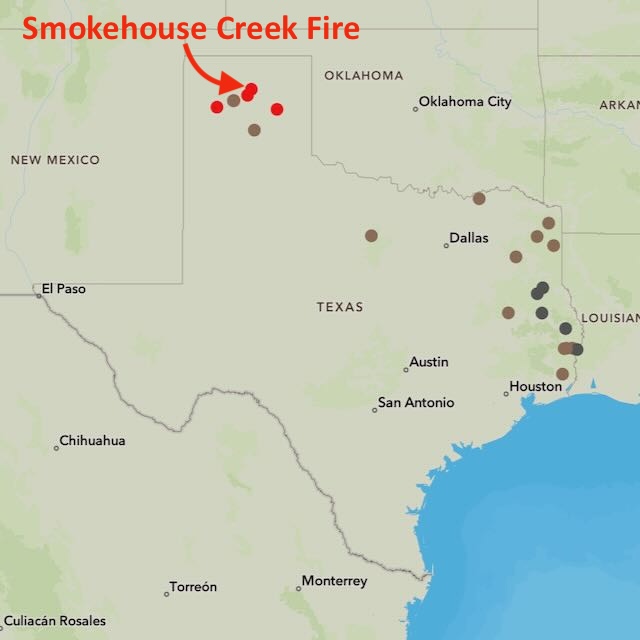
Apocalyptic scene in the Texas Panhandle right now. The Smokehouse Creek Wildfire has burned more than 500,000 acres, which is the equivalent of all of Lee County.
Video courtesy of Greenville Fire-Rescue Department pic.twitter.com/RoTQ7ho0jM
— Peter Busch (@peterbuschTV) February 28, 2024
Smokehouse Creek wildfire now biggest in Texas history
A cold front pushed through the Texas Panhandle on Monday, bringing high winds. And that’s when the fire started and began to spread. As of this morning (March 1, 2024), the Smokehouse Creek fire is only 5% contained. During the day yesterday, the Texas A&M Forest Service reported that the fire had burned over 1 million acres, ranking it among the largest of North American wildfires and making it #1 in Texas history.
The previous record-holder for largest fire in the state of Texas was the East Amarillo Complex fire in 2006. It burned 907,000 acres overall.
BREAKING: The deadly #SmokehouseCreekFire is now the largest wildfire in Texas history, consuming over one million acres. pic.twitter.com/wlM4RSOogv
— The Weather Channel (@weatherchannel) February 29, 2024
Only 3% contained so far
At this writing (9:30 a.m. on February 29), the Smokehouse Creek fire is still raging, with only 3% containment.
Temperatures in the Texas Panhandle dipped temporarily on Tuesday, as a cold front moved through the area. As a result, winds associated with the cold front caused the fires to change from an eastward advance to a southward advance. On Tuesday, winds were gusting up to 65 miles an hour (105 kph).
But later, the wind gusts had died down by Wednesday to up to 19 miles an hour (30 kph). Also, throughout this week, low humidity has made for dry air.
On Thursday, some media around Amarillo, Texas – in the southern Texas Panhandle – were reporting rain and snow.
Snow, some of it heavy, continues to move northeast across the Panhandles. Snow will reduce the visibility and there may be some slippery roads. #phwx #txwx #okwx pic.twitter.com/BhI1HaV3au
— NWS Amarillo (@NWSAmarillo) February 29, 2024
Wildfire affecting humans and animals
The wildfires in the Texas Panhandle have caused evacuations and school closures. In particular, on Tuesday, the Pantex Nuclear Weapons Plant in Amarillo paused operations and evacuated nonessential personnel until it was deemed safe to continue normal operations.
Both horses and cattle have been running from the flames in the Texas Panhandle.
@nbcnews Texas cattle stampede away from plumes of smoke as wildfires covering 300,000 acres force thousands to evacuate.
@cbsnews As the Texas Panhandle battles out-of-control wildfires – including one that alone is an estimated 500,000 acres – horses were seen running along a highway trying to escape the smoke and flames. #texas #wildfire #news ? original sound – cbsnews
A view of the Texas wildfires from above
Flew over crazy scenes in the Texas panhandle, wildfires have broken out everywhere it seemed. They were spanning the skyline! Sorry for the picture quality, they don’t do it justice, the plane cabin lights were on. Was a smoky sky all the way into OKC #txwx #okwx pic.twitter.com/4sDTHMGy9Z
— Brandon Sullivan (@btsullivan91) February 27, 2024
More about Texas fires on social media
As the cold front pushed through, @Sierra_Lindsey3 and I were in Canadian Texas. The speed of which the wind shifted and started fueling fire to the south was nothing short of extreme with fire behavior. We were then stuck with a shelter in place order as the entire town was… pic.twitter.com/JpKGtHQ5aP
— Jordan Hall (@JordanHallWX) February 28, 2024
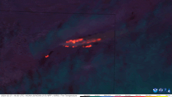
This Fire Temperature RGB view of the Texas cold front passage that redirected the #SmokehouseCreekFire propagation to a southerly direction is a classic example of how satellite data aids firefighting efforts. More imagery, details and NGFS tools at https://t.co/ZdUVfNJGnO #TXwx pic.twitter.com/39emwnyJmL
— UW-Madison CIMSS (@UWCIMSS) February 28, 2024
Here is where the satellite is picking up wildfires in the Panhandles this afternoon, February 28th, 2024. #phwx #txwx #okwx pic.twitter.com/9homBq0EvM
— NWS Amarillo (@NWSAmarillo) February 28, 2024
Public information map of the #SmokehouseCreekFire showing an estimated 500,000 acres as of Feb. 28, 2024. This is a preliminary perimeter and subject to change. #txfire pic.twitter.com/ZWl4rzrzoO
— Incident Information – Texas A&M Forest Service (@AllHazardsTFS) February 28, 2024
As the fast-moving cold front encounters the wildfires scorching Texas and Oklahoma, the fires are oriented from east to south following the new wind direction. pic.twitter.com/zX3aYtJBfU
— CIRA (@CIRA_CSU) February 28, 2024
Meanwhile, in neighboring Oklahoma and faraway Australia
Nearby northwestern Oklahoma is also being plagued with wildfires this week. As a result, officials reported some structures and livestock have been lost.
Also, as the wildfires rage in the Texas Panhandle and in nearby Oklahoma, bushfires are raging in parts of Australia, on the opposite side of Earth’s globe. It’s late summer now in the Southern Hemisphere. And hot, dry and windy conditions have made Australia ripe for fire danger. In fact, fires have been raging for more than a week in Victoria, a state in the southeastern part of Australia that contains the city of Melbourne. At this time, the fires are west of Melbourne, a city of five million.
Victoria fires live updates: Soaring temperatures forecast across the state; Bayindeen bushfire still out of control https://t.co/yTOYaRBit8 #ClimateChange #ClimateEmergency #ClimateActionNow #GlobalBoiling #SevereWeather #Wildfire #Bayindeen #Ballarat #Victoria #Australia
— firehorse23 (@firehorse249791) February 28, 2024
Bottom line: A Texas wildfire is now the largest in the state’s history. Oklahoma is also battling wildfires. And in Australia, where it’s now late summer, fires have been raging for more than a week, west of the city of Melbourne.
Read more: This Is Wildfire: Tips on preparing yourself and your home
Like what you read?
Subscribe and receive daily news delivered to your inbox.
More from
Kelly Kizer Whitt


