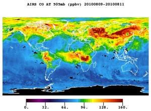
Scientist Ron Gelaro leads NASA’s efforts to predict weather, across the globe, using computer simulations. EarthSky spoke with Ron Gelaro in December, 2010. Dr. Gelaro said NASA’s Aqua satellite makes key measurements used in the computer models that forecast weather. He said:
The Aqua satellite, and the instruments on board, have given us really a quantum leap in terms of what we call vertical resolution, or detail, from space, of these various parameters, things like temperature and humidity. And it’s key to have this sort of information, to have a complete, three-dimensional picture of the atmosphere.
Weather models, said Gelaro, are complicated computer programs that follow the equations from science on how the atmosphere works. He said:
A weather model is our basic tool for taking information about the atmosphere at a given time, say we make a measurement of wind, temperature, or pressure, and extrapolating that information forward in time in some physically consistent way.
So with that kind of capability, if you can tell me the temperature, or some other variable now, I can use a weather model to make a prediction of what those fields might look like maybe an hour or two hours from now. Then I can take that result, put it back into my computer model, and step out a little further in time. And we repeat that process continuously until we get out to the kind of forecasts that we’re used to hearing, maybe a day forecast or a five day forecast.
Dr. Gelaro explained what a weather model is.
A weather model is a computer program, a very complex computer program, that contains the equations and basic governing laws that dictate how different atmospheric parameters relate to each other. Say, how temperature relates to pressure, relates to winds, and most importantly how changes in these parameters, in one parameter, might affect change in another parameter. So given a change in wind or pressure, how that might change the temperature.
The Aqua satellite, said Gelaro, has helped scientists understand and forecast weather.
The Aqua satellite has a broad array of instruments, imagery and pictures, very high resolution pictures of the atmosphere, and surface properties, as well as very detailed, three-dimensional vertical profiles of things like temperature and humidity. And it’s key to have this sort of information, to have a complete, three-dimensional picture of the atmosphere. And the Aqua satellite, and the instruments on board, have given us really a quantum leap in terms of what we call vertical resolution, or detail, from space, of these various parameters to help us fill in this picture, this complete, three-dimensional picture of what the atmosphere looks like.
Gelaro made the connection between weather models and the Aqua satellite.
We have two types of information. We have observations, like we get from Aqua, which tend to be quite accurate, but they can also be very disparate in time and space. Sometimes we have observations in one location where the satellite’s flying, and at a given moment, we won’t have observations somewhere else. So they give us accurate information, but as I said, somewhat separate and in different parts of the globe, at any given moment. The models on the other hand, give us a very complete, three-dimensional picture of the atmosphere, at any given moment, because our model covers the entire Earth in terms of what we’re depicting.
But it has certain errors and limitations. What we do to produce the best picture of the atmosphere we can come up with is to blend these two pieces of information together, that is we blend the observations with the models and the physical laws that we think should govern the way that all the various parameters relate to come up with an even more accurate depiction of the atmosphere than even the models or the observations can give us alone.
The weather, said Gelaro, is so complex that it will probably never be completely understood.
Our understanding of the weather is actually, generally quite good. But it’s also a function of the scale of the processes. We understand large-scale circulations, processes and those sort of phenomenon that are easy to observe, we understand those very well, in terms of our physical laws. As it gets to more complex processes, as they relate to clouds, or smaller motions, those we understand less well. But the basic problem with the atmosphere is, there really is an inherent predictability limit.
The atmosphere is what we call a chaotic system. What that means is that it’s very difficult to come up with a regular cause and effect sort of relationship. There are real limitations on how predictable the atmosphere really is.
We’ve made a lot of progress, and things like the Aqua satellite have certainly moved us quite along. But I think I would say that weather forecasts are generally, by objective measures they’re much more accurate than they used to be. They’ll never be perfect, but we are making progress.
Our thanks today to NASA’s Aqua Mission, improving our knowledge of our home planet through satellite observations.
Listen to the 90-second and 8-minute EarthSky interviews with Ron Gelaro on the Aqua satellite and weather forecasting (at top of page.)


