


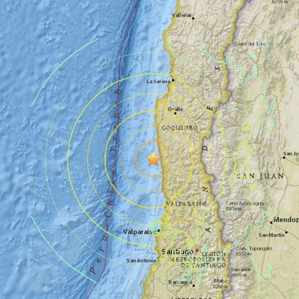
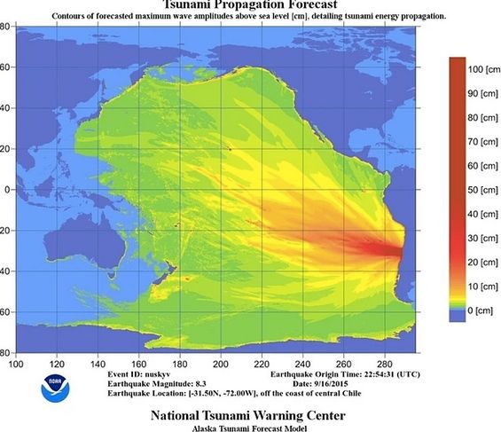
The U.S. Geological Survey (USGS) has reported a series of earthquakes and aftershocks along the coast of Chile, beginning last night (September 16, 2015) with an 8.3-magnitude earthquake, an extremely powerful earthquake. The first quake occurred at 22:54 UTC (7:54 p.m. local time in Chile, or 5:45 p.m. Central Daylight Time). Moderate tsunami waves – the highest measuring 15 feet in height (about 4.5 meters) at Coquimbo, Chile – subsequently struck Chile’s coast, and the National Tsunami Warning Center has tsunami advisories now in effect for Hawaii and the coast of California. The Associated Press reported the following:
… the effects from the tsunami would arrive in Hawaii about 6 a.m. (PDT) Thursday.
A similar advisory was issued for southern and central California. That advisory affects about 300 miles [500 km] of coastline stretching from the southern end of Orange County to most of San Luis Obispo County on the central coast. The possible changes associated with the advisory are expected to hit first in the south at about 4:45 a.m. (PDT) Thursday and move north in the minutes that follow.
It’s an advisory, not a warning for California and Hawaii, and “widespread inundation of land is not expected” for these advisory areas, according to the National Tsunami Warning Center. Forecasters do, however, expect possibly dangerous ocean currents and waves for several hours.
Last night, Valparaiso, Chile and Quintero, Chile saw waves of about 6 feet (2 meters). Between 3- and 10-foot waves were reported possible for French Polynesia. Waves between 1 foot and 3 feet were reported possible along some coasts in Mexico, Ecuador, Japan, Russia and New Zealand.
Click here for live updates from The Guardian on the earthquake aftermath
Yesterday's Chile earthquake created a 16-foot wave and evacuated 1m people: https://t.co/WiRQdp5xBr #TerremotoChile pic.twitter.com/Y8Wp2hyQmt
— CNN International (@cnni) September 17, 2015
According to CNN, at least five people were killed and 1 million evacuated from affected areas, after the powerful 8.3-magnitude earthquake. Following the earthquake, the tsunami waves struck, causing flooding.
Details of the 8.3-magnitude quake from USGS follow:
Time
2015-09-16 22:54:32 (UTC)
Nearby Cities
54km (34mi) W of Illapel, Chile
76km (47mi) WNW of Salamanca, Chile
109km (68mi) NNW of La Ligua, Chile
118km (73mi) SSW of Ovalle, Chile
233km (145mi) NNW of Santiago, Chile
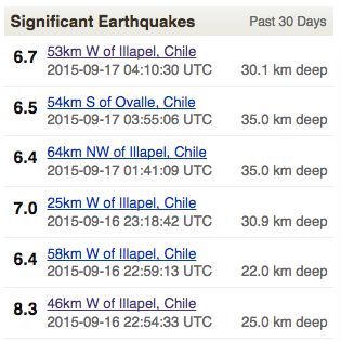
The 8.3-magnitude quake was followed by many strong aftershocks along Chile’s coast (see chart below). Although the September 16 quake, was particularly strong, earthquakes are common and expected along the coast of Chile. USGS explained:
The September 16, 2015 M 8.3 earthquake west of Illapel, Chile, occurred as the result of thrust faulting on the interface between the Nazca and South America plates in central Chile. At the latitude of this event, the Nazca plate is moving towards the east-northeast at a velocity of 74 mm/yr with respect to South America, and begins its subduction beneath the continent at the Peru-Chile Trench, 85 km to the west of the September 16 earthquake. The size, location, depth and mechanism of this event are all consistent with its occurrence on the megathrust interface in this region.
Bottom line: On September 16, 2015, an 8.3-magnitude earthquake struck off the coast of Chile. Small-scale tsunami waves (one up to 10 feet, or about 3 meters in height), and a tsunami warning was still in effect for Hawaii Wednesday evening.
Like what you read?
Subscribe and receive daily news delivered to your inbox.
More from
Deborah Byrd


