


Landsat 9 returns 1st Earth images
Most of us don’t remember the days before the Landsats and other Earth-observing satellites. How did people back then know what Earth changes were taking place? NASA launched Landsat 1 in 1972. And NASA launched its latest Landsat – Landsat 9 – on September 27, 2021. This newest Earth-observing satellite returned its first Earth images on October 31. NASA released Landsat 9’s first-light images on November 5. NASA administrator Bill Nelson said:
Landsat 9’s first images capture critical observations about our changing planet and will advance this joint mission of NASA and the U.S. Geological Survey (USGS) that provides critical data about Earth’s landscapes and coastlines seen from space.
Nelson said the Landsat program has:
… the proven power to not only improve lives but also save lives.
And that’s surely going to be increasingly true as global warming continues, bringing about rising seas and more weather extremes. We now have nearly 50 years of Earth observations from space. NASA said Landsat will help humanity manage natural resources and get a better understanding of the impacts of climate change. And just in time, too, don’t you think? Where would we on Earth be today, without this space-based Earth-observing technology?

First-light images
Landsat 9 replaces the Landsat 7; Landsat 8 is still in operation. Scientists point to upgrades with Landsat 9 that include the ability to differentiate between 16,000 shades of a given wavelength of color. In other words, subtle changes on Earth will become clear with the new data. The new satellite is still performing test runs. It’s undergoing a 100-day period during which scientists will test its systems and calibrate its instruments. Then USGS will take the reins, likely in January. Eventually, Landsat 9 and Landsat 8 are expected to acquire about 1,500 Earth images daily, covering the globe every eight days.
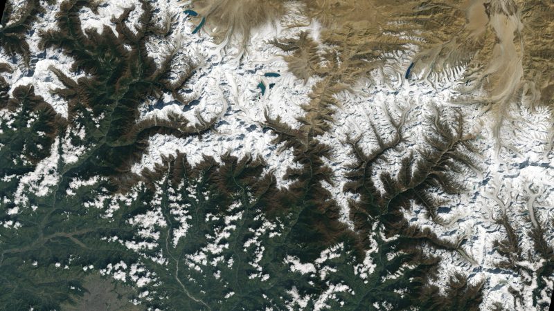
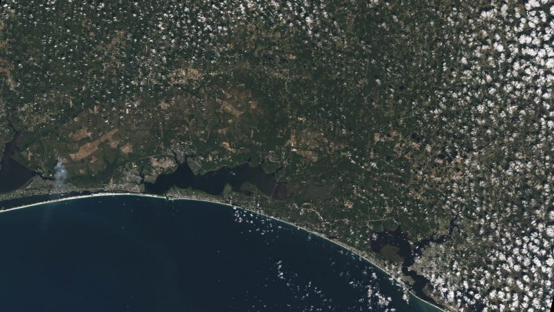
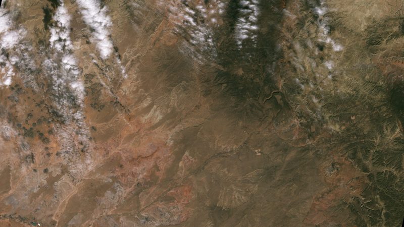
The first-light images put a spotlight on Detroit, the Florida Panhandle, the American Southwest’s Navajo Nation, the western coast of Australia and the Himalayas. Jeff Masek, a project scientist on Landsat 9, commented:
First light is a big milestone for Landsat users. It’s the first chance to see the kind of quality that Landsat 9 provides. And they look fantastic. When we have Landsat 9 operating in coordination with Landsat 8, it’s going to be this wealth of data, allowing us to monitor changes to our home planet every eight days.
Instruments on Landsat 9
Landsat 9 houses two science instruments: the Operational Land Imager 2 (OLI-2) and the the Thermal Infrared Sensor 2 (TIRS-2).
The Operational Land Image 2 detects visible, near-infrared and shortwave-infrared light in nine wavelengths.
The Thermal Infrared Sensor 2 detects thermal radiation in two wavelengths to measure Earth’s surface temperatures and its changes.
These instruments will provide Landsat 9 users with data at a scale where they can separate human and natural causes of change. Karen St. Germain, Earth Science Division director at NASA Headquarters in Washington, said:
The data and images from Landsat 9 are expanding our capability to see how Earth has changed over decades. In a changing climate, continuous and free access to Landsat data, and the other data in NASA’s Earth observing fleet, helps data users, including city planners, farmers and scientists, plan for the future.

Monitoring Earth from above
This eye-from-the-sky view on Earth helps us on the ground get a better picture of what’s happening on our planet. Scientists hope to be able to have weekly tropical deforestation alerts, water quality monitoring, and crop condition reports, among other helpful insights that Landsat 9 can provide on a regular basis. USGS Acting Director Dr. David Applegate said:
The incredible first pictures from the Landsat 9 satellite are a glimpse into the data that will help us make science-based decisions on key issues including water use, wildfire impacts, coral reef degradation, glacier and ice-shelf retreat and tropical deforestation. This historic moment is the culmination of our long partnership with NASA on Landsat 9’s development, launch and initial operations, which will better support environmental sustainability, climate change resiliency and economic growth – all while expanding an unparalleled record of Earth’s changing landscapes.
Bottom line: Landsat 9 took its first images of Earth on October 31, 2021. Enjoy these views of Earth from space, as Landsat 9 begins its monitoring of the land below.
Like what you read?
Subscribe and receive daily news delivered to your inbox.
More from
Kelly Kizer Whitt


