


As of last week (August 14, 2016) Arctic sea ice extent – the area of the Arctic ocean covered with ice – was 5.61 million square kilometers (2.17 million square miles). That’s the third lowest extent in the satellite record for this date.
A decade ago, this year’s sea ice extent would have set a new record low, but now these low levels of sea ice might be the new normal, according to NASA scientists.
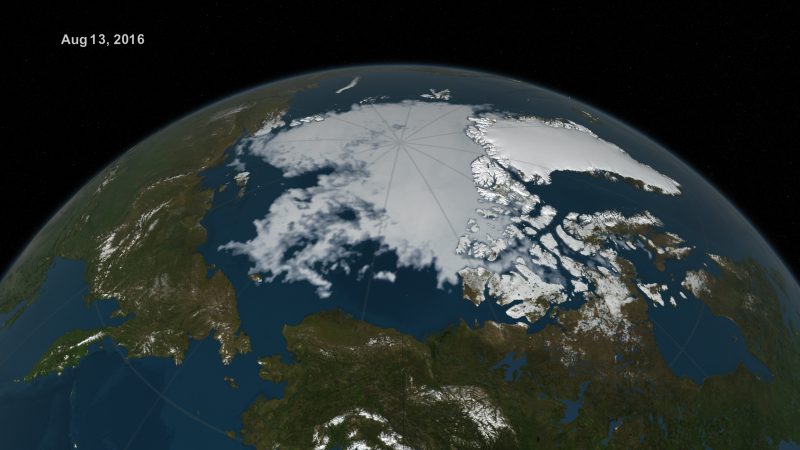
In this animation, the daily Arctic sea ice and seasonal land cover change progress through time, from the prior sea ice maximum March 24, 2016, through August 13, 2016. The Arctic sea ice cover likely won’t reach its yearly minimum extent until mid-to-late September. Credit: NASA Goddard’s Scientific Visualization Studio/Cindy Starr
Walt Meier is a sea ice scientist at NASA’s Goddard Space Flight Center in Greenbelt, Maryland. Meier said in a statement:
Even when it’s likely that we won’t have a record low [in 2016], the sea ice is not showing any kind of recovery. It’s still in a continued decline over the long term. It’s just not going to be as extreme as other years because the weather conditions in the Arctic were not as extreme as in other years.
A decade ago, this year’s sea ice extent would have set a new record low and by a fair amount. Now, we’re kind of used to these low levels of sea ice – it’s the new normal.

This year’s melt season in the Arctic Ocean and surrounding seas started with record melting in March, but the melt slowed down in June, making it highly unlikely that this year’s summertime sea ice minimum extent will set a new record. According to a NASA statement:
This year’s sea ice cover of the Barents and Kara seas north of Russia opened up early, in April, exposing the surface ocean waters to the energy from the sun weeks ahead of schedule. By May 31, the extent of the Arctic sea ice cover was comparable to end-of-June average levels. But the Arctic weather changed in June and slowed the sea ice loss. A persistent area of low atmospheric pressure, accompanied by cloudiness, winds that dispersed ice and lower-than-average temperatures, didn’t favor melt.
The rate of ice loss picked up again during the first two weeks of August, and is now greater than average for this time of the year.
A strong cyclone has been moving through the Arctic this month, similar to one that occurred in early August 2012. Four years ago, said Meier, the storm caused an accelerated loss of ice during a period when the decline in sea ice is normally slowing because the sun is setting in the Arctic. However, Meier said, the current storm doesn’t appear to be as strong as the 2012 cyclone and ice conditions are less vulnerable than four years ago.
This year is a great case study in showing how important the weather conditions are during the summer, especially in June and July, when you have 24 hours of sunlight and the sun is high in the sky in the Arctic. If you get the right atmospheric conditions during those two months, they can really accelerate the ice loss. If you don’t, they can slow down any melting momentum you had. So our predictive ability in May of the September minimum is limited, because the sea ice cover is so sensitive to the early-to-mid-summer atmospheric conditions, and you can’t foresee summer weather.
Enjoying EarthSky? Sign up for our free daily newsletter today!
Bottom line: By mid-August, the 2016 Arctic sea ice extent was the third lowest extent in the satellite record for that date. NASA scientists said that a decade ago, this year’s sea ice extent would have set a new record low, but now these low levels of sea ice might be the new normal.
Like what you read?
Subscribe and receive daily news delivered to your inbox.
More from
Eleanor Imster


