


Hurricane Harvey changed the landscape of southern Texas and the lives of millions of people. The storm also changed the surface profile of the Gulf of Mexico, say NASA scientists, though those effects are likely to be short-lived.
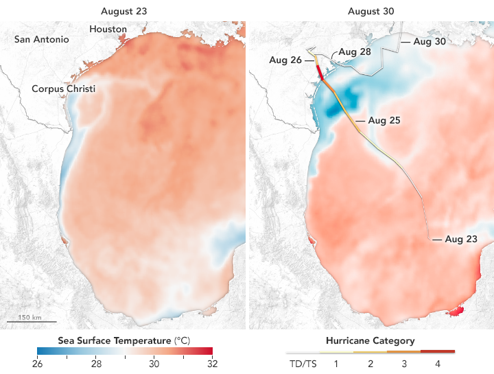
When Harvey crossed the Yucatán Peninsula into the Gulf of Mexico on August 22–23, 2017, the tropical depression moved into waters that were warmer than the long-term average – by 1.5 to 4 degrees Celsius (2.5 to 7 degrees F.)
Hurricanes feed off of warm ocean temperatures, like a fire relies on a steady oxygen supply to keep burning.
…So this deep, warm pool of water helped provide additional fuel for Harvey to intensify.
That’s according to Dalia Kirschbaum, a scientist and natural hazards specialist at NASA’s Goddard Space Flight Center.
Once in the Gulf, Harvey grew rapidly and sped toward the Texas coast as a category 4 hurricane — then lingered for five days as a tropical storm. In the process, the storm dropped unprecedented amounts of rainwater on Houston and southern Texas while churning up the Gulf of Mexico.
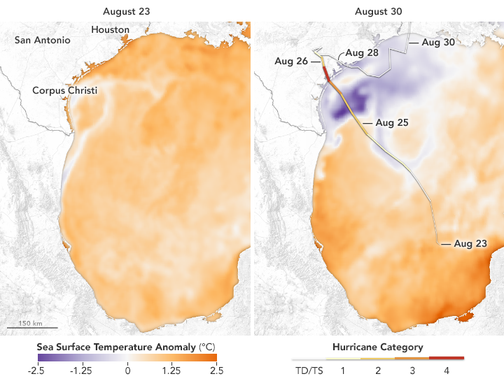
All of the fresh rainwater and the ocean mixing from the storm combined to dramatically alter the surface waters of the Gulf. According to a statement for NASA Earth Observatory:
Cooling naturally as it rose through the atmosphere, the water that fell back onto the sea as rain likely would have been cooler than the surface waters. At the same time, the winds and waves of the storm worked to disperse warm surface water and to bring up cooler water from the ocean depths.
In theory, scientists say, the cooler water now near the surface of the northern Gulf of Mexico should make it less likely for a new storm to develop or intensify there in the coming weeks. However, the waters of the Gulf are not exactly cool. Scientists generally agree that sea surface temperatures should be above 27.8°C (82°F) to promote the development and intensification of hurricanes. (There are some exceptions.) So even some of the light blues on the sea surface temperature maps above are still warm enough for storms.
Bottom line: NASA Earth Observatory maps show how of the fresh rainwater and ocean mixing from hurricane Harvey combined to dramatically alter the surface waters of the Gulf of Mexico.
Enjoying EarthSky so far? Sign up for our free daily newsletter today!
Like what you read?
Subscribe and receive daily news delivered to your inbox.
More from
Eleanor Imster


