


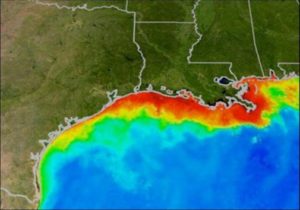
In a statement released June 7, 2018, NOAA said scientific models suggest that this summer’s Gulf of Mexico hypoxic zone or “dead zone” will be approximately 5,780 square miles (14,760 square km), about the size of the U.S. state of Connecticut. That’s similar to the 33-year average of 5,460 square miles (14,140 square km), and smaller than 2017’s Gulf dead zone – which at 8,776 square miles (22,730 square km) was the largest measured since mapping began in 1985.
Hypoxic zones – aka “dead zones” – are areas in the ocean of such low oxygen concentration that animal life suffocates and dies. A dead zone forms in the Gulf of Mexico every summer. Nutrients from the Mississippi River watershed, particularly nitrogen and phosphorus, fertilize the Gulf’s surface waters to create excessive amounts of algae. When the algae decomposes in the deepest parts of the ocean, it leads to oxygen distress and can kill organisms even in the Gulf of Mexico’s richest waters. These low oxygen conditions threaten living resources including fish, shrimp and crabs, which humans depend upon for food and industry.
Even though NOAA is predicting an average dead zone this summer, the dead zone remains three times larger than the long-term target set by the Interagency Mississippi River and Gulf of Mexico Hypoxia Task Force, a group charged with reducing the Gulf dead zone.
Steve Thur is the director of NOAA’s National Centers for Coastal Ocean Science. Thur said:
The Gulf’s recurring summer hypoxic zone continues to put important habitats and valuable fisheries at risk. Although there has been some progress in reducing nutrients, the overall levels remain high and continue to strain the region’s coastal economies.
NOAA issues a dead zone forecast each year. The forecast is based on nitrogen runoff and river discharge data from the U.S. Geological Survey (USGS). The forecast assumes typical weather conditions, but the dead zone could be disrupted by hurricanes and tropical storms. A NOAA-supported monitoring survey will confirm the size of the 2018 Gulf dead zone in early August.
According to a NOAA statement:
Higher river discharge in May carries a larger nutrient load into the Gulf of Mexico, one factor that contributes to a larger hypoxic zone. This past May, discharge in the Mississippi and Atchafalaya rivers was about 4 percent above the long-term average (between 1980 and 2017). The USGS estimates that this near-average river discharge carried 115,000 metric tons of nitrate and 18,500 metric tons of phosphorus into the Gulf of Mexico in May. These nitrate loads were about 13 percent below the long-term average, and the phosphorus loads were about 10 percent above the long-term average.
Bottom line: NOAA scientists project that the 2018 summer hypoxic zone or ‘dead zone’ in the Gulf of Mexico will be about the size of Connecticut.
Help EarthSky keep going! Please donate what you can to our annual crowd-funding campaign.
Like what you read?
Subscribe and receive daily news delivered to your inbox.
More from
Eleanor Imster


