


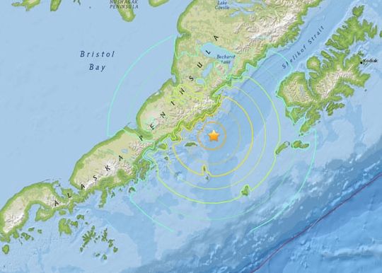
The U.S. Geological Survey (USGS) says a 6.7-magnitude earthquake has struck off in an earthquake-prone, sparsely populated region off the southwest coast of Alaska. The quake occurred at 3 a.m. EDT (0700 UTC) Friday morning, May 29, 2015. The epicenter is approximately 70 miles (110 km) south-southeast of Ugashik – nearly 400 miles (600 km) southwest of Alaska’s largest city, Anchorage – with the earthquake’s center estimated at 20 miles (33 km) deep.
The Pacific Tsunami Warning Center said that no tsunami was expected. There were no immediate reports of casualties or damage.
No distant #tsunami threat from magnitude 6.8 Alaska #earthquake https://t.co/2tOlRAZzMS #PTWC
— NWS PTWC (@NWS_PTWC) May 29, 2015

Details of the quake from USGS follow:
Nearby Cities
98km (61mi) NNW of Chirikof Island, Alaska
637km (396mi) SW of Anchorage, Alaska
673km (418mi) SW of Knik-Fairview, Alaska
1032km (641mi) SSW of Fairbanks, Alaska
1316km (818mi) W of Whitehorse, Canada
Earthquakes are common on this part of Earth, which is known to geologists as the Aleutian arc. This large volcanic arc consists of a number of active and dormant volcanoes that have formed as a result of subduction – the movement of one great land plate on Earth beneath another. Here, the Pacific plate subducts into (dives below) Earth’s mantle beneath the North America plate.
This subduction is responsible for the many moderate to large earthquakes occurring each year here. Since 1900, this region has hosted 12 large earthquakes of greater than 7.5 magnitude, including magnitude-8.0 and magnitue-7.9 earthquakes in the Andreanof Islands (1986 and 1996), and a 2003 magnitude-7.8 Rat Islands earthquake.

Bottom line: A deep earthquake took place 3 a.m. EDT (0700 UTC) Friday morning, May 29,2015. The epicenter in the earthquake-prone Aleutian arc, 70 miles (110 km) south-southeast of Ugashik.
Like what you read?
Subscribe and receive daily news delivered to your inbox.
More from
Deborah Byrd


