


The animation above shows a rotating globe of the new Unified Geologic Map of the Moon with shaded topography from NASA’s LOLA mission to the moon (LOLA stands for Lunar Orbiter Laser Altimeter).
You can directly download the new moon map at its website: https://astrogeology.usgs.gov/search/map/Moon/Geology/Unified_Geologic_Map_of_the_Moon_GIS.
[NOTE ADDED APRIL 29: This USGS website, where you can download the map, was down when we checked it earlier today. It appears to be working now.]
The U.S. Geologic Survey (USGS) announced the new Unified Geologic Map of the Moon on April 20, 2020. They said it shows the moon’s surface geology, with rock layers and craters charted “in great detail.” The map is a synthesis of six Apollo-era regional geologic maps, updated with data from more recent moon missions.
USGS said it’s designed to serve as “the definitive blueprint” for lunar science and future human missions to the moon, and to be used by the international scientific community, educators and the public at large.
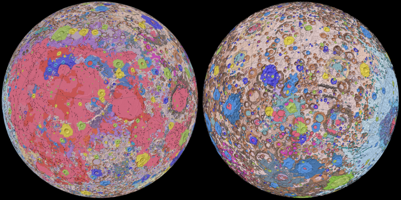
To create the new digital map, scientists used information from six Apollo-era regional maps along with updated information from recent satellite missions to the moon.
The existing historical maps were redrawn to align them with the modern data sets, thus preserving previous observations and interpretations. Along with merging new and old data, USGS researchers also developed a unified description of the stratigraphy, or rock layers, of the moon. This resolved issues from previous maps where rock names, descriptions and ages were sometimes inconsistent.
Corey Fortezzo, USGS geologist, is lead author of the study, published by the Lunar and Planetary Institute. Fortezzo said in a statement:
This map is a culmination of a decades-long project. It provides vital information for new scientific studies by connecting the exploration of specific sites on the moon with the rest of the lunar surface.
Topography for the north and south poles was supplemented with data from NASA’s Lunar Orbiter Laser Altimeter (LOLA), a robotic spacecraft currently orbiting the moon. Data collected by the Lunar Reconnaisance Orbiter (LRO) have been described as essential for planning NASA’s future human and robotic missions to the Moon. Its detailed mapping program is identifying safe landing sites, locating potential resources on the moon, characterizing the radiation environment, and demonstrating new technologies.
Elevation data for the moon’s equatorial region came from stereo observations collected by the Terrain Camera on the recent SELENE (Selenological and Engineering Explorer) mission led by JAXA, the Japan Aerospace Exploration Agency.
Learn more at the Unified Geologic Map of the Moon website.
Bottom line: The first-ever comprehensive geological map of the entire moon has been created.
Source: Release of the digital unified global geologic map of the moon at 1:5,000,000-scale
Like what you read?
Subscribe and receive daily news delivered to your inbox.
More from
Eleanor Imster


