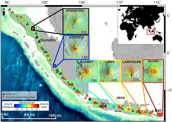
A new study by scientists at the University of Miami (UM) Rosenstiel School of Marine & Atmospheric Science uses Interferometric Synthetic Aperture Radar (InSAR) data to investigate deformation prior to the eruption of active volcanoes in Indonesia’s west Sunda arc. Led by geophysicist Estelle Chaussard and UM Professor Falk Amelung, the study uncovered evidence that several volcanoes did in fact ‘inflate’ prior to eruptions due to the rise of magma. The fact that such deformation could be detected by satellite is a major step forward in volcanology; it is the first unambiguous evidence that remotely detected ground deformation could help to forecast eruptions at volcanoes.

“Surveying entire volcanic regions using satellite data is of primary importance to the detection of ground deformation prior to the onset of eruptions. If volcanic inflation is observed, it can help us to predict where the next eruption may occur. Moreover, in regions like Indonesia, where volcanoes are prevalent and pose a threat to millions of people, and where ground-based monitoring is sparse, remote sensing via satellite could become a major forecasting tool,” said Chaussard.
Analyzing more than 800 InSAR images from the Japanese Space Exploration Agency’s ALOS satellite, the team surveyed 79 volcanoes in Indonesia between 2006 and 2009. They detected deformation at six volcanic centers, three of which erupted after the observation period, confirming that inflation is a common precursor of volcanic eruptions at west Sunda volcanoes.
“The notion of detecting deformation prior to a volcanic eruption has been around for a while,” said Amelung, who has been studying active volcanoes for 15 years. “Because this region is so volcanically active, our use of InSAR has been very successful. We now have a tool that can tell us where eruptions are more likely to occur.”
The team will now study other parts of Indonesia and then in the Philippines, also prone to volcanic activity. They will use data from the Japanese Space Agency’s ALOS-2 which will be launched next year.
“The monitoring of changes to the Earth’s surface helps us to better predict the onset of volcanic activity, which can have devastating impacts on human life,” said Amelung. “Like with earthquakes and tsunamis, however, we cannot predict activity with certainty, but we hope that new tools like satellite remote sensing will help us to gather critical information in near real-time so we can anticipate the risk of eruptions and deploy resources in a timely manner.”
This study also reveals that there are regional trends in depths of magma storage. Indonesian volcanoes have magma reservoirs at shallow depths probably due to the tectonic setting of the region, which account for the way the region is deforming. If a volcanic chamber is located close to the surface it is usually associated with a higher risk for significant eruption, thus these observations play a major role in volcanic hazard assessment.
University of Miami Rosenstiel School of Marine & Atmospheric Science


