


Today in science: January 16, 1909
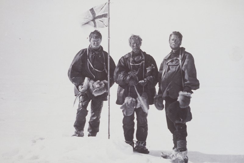
On today’s date in 1909, three members of an Ernest Shackleton expedition to Antarctica – Edgeworth David, Douglas Mawson and Alistair Mackay – raised a British flag and took a photograph to commemorate the moment they thought they’d reached Earth’s magnetic south pole. They’d left McMurdo Sound, at the sea edge of the Antarctic continent, four months earlier.
Magnetic south is different from Earth’s geographic south pole, by the way (just like the magnetic north is different from the north pole). And the 1908-1909 expedition took place several years before a team led by Norwegian explorer Roald Amundsen reached the geographic South Pole on December 14, 1911.
It was also before scientists realized that Earth’s magnetic poles wander, or move, across Earth’s surface.
The 2022 lunar calendars are here. Order yours before they’re gone!
A challenging Antarctic trek
Like all Antarctic journeys in the early 20th century – when Earth’s poles were discovered and began to be explored – the search for magnetic south was grueling. The men had to haul their own sledges by hand through a completely unknown terrain. Crevasses – deep gashes in the ice – slowed them down. When it became clear the march was taking longer than expected, the men had to reduce their rations.
But by early January 1909, the team reached the polar plateau, where the thin air made breathing more difficult and where, on January 11, David recorded the temperature at -12 F (-24 C). Finally, on January 15, Mawson calculated that they were about 13 miles (21 km) from magnetic south. The men left their heavy gear and made a final push to a point on Earth’s globe at 72° 25′ south latitude, 155° 16′ east longitude.
They raised the Union Jack and took their photo. They then immediately began making their way back to the ship Nimrod, which carried Shackleton’s team from New Zealand to the southern continent of Antarctica the previous year.
Mawson would later realize that he’d overlooked some important calculations made several years previously by another researcher. In 1913, Edgeworth David admitted that their party had reached only “an outlier of the main magnetic pole,” not the true magnetic south pole itself.
Even so, their valiant effort still stands out in the history of science and in polar exploration.
The wandering poles
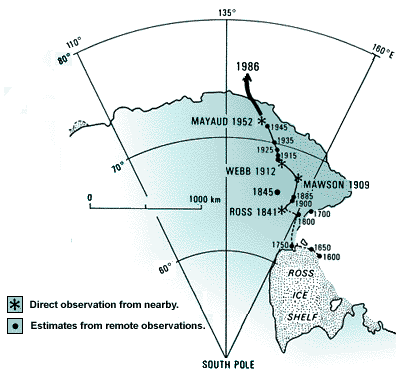
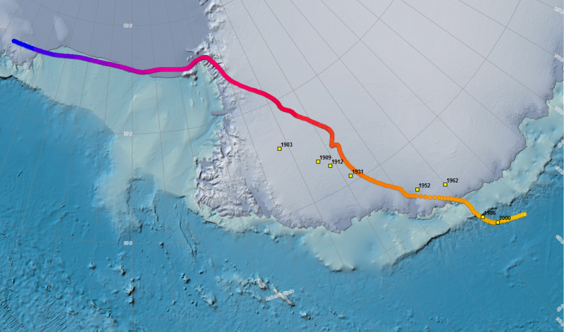
Even if they had found the true point of magnetic south in 1909, that point would no longer be the magnetic south pole today. The magnetic north and south poles wander yearly due to changes in Earth’s magnetic field.
The location of the south magnetic pole in 2020 – the last date we could find – was 64.07°S, 135.88°E. That number comes from the Australian Antarctic Program. This map from NOAA shows magnetic south in 2020 off the coast of the Antarctic continent, in the Southern Ocean surrounding the continent.
Why magnetic and geographic poles don’t match
What’s the difference between the magnetic and geographic poles? When you use a compass, the compass needle points toward magnetic north, not geographic north. The north and south magnetic poles are part of Earth’s magnetic field. The magnetic poles are where Earth’s magnetic field lines start and finish.
On the other hand, geographic north relates to Earth’s spin on its axis. If you imagine a stick through Earth to represent Earth’s spin axis, the geographic north pole is where the northern part of the stick exits Earth’s body. From geographic north, Earth’s pole star, Polaris, is overhead (although not precisely overhead because it’s not precisely above geographic north).
So magnetic north and geographic north don’t match, because they describe different aspects of Earth.
Bottom line: On January 16, 1909, a Shackleton expedition team in Antarctica thought they’d found the magnetic south pole. The magnetic south and north poles wander every year.
Read more: Are the Earth’s magnetic poles about to swap places?
Like what you read?
Subscribe and receive daily news delivered to your inbox.
More from
Deborah Byrd


