UPDATED FEBRUARY 29, 2012 12 CST (18 UTC) The U.S. Midwest has been hit by very active weather and a line of tornadoes that took lives and destroyed property overnight on February 28. At least nine people were killed and parts of several towns were flattened, according to local officials on February 29. Kansas Governor Sam Brownback issued a disaster declaration for his state, parts of which were without power.
Harrisburg, Illinois was the hardest hit overnight last night. Six deaths were reported there, along with nearly 100 injuries and at least 200 homes destroyed or damaged by a suspected tornado, according to MSNBC, which also reported:
Three other deaths … in Missouri, where a suspected tornado hit a mobile home park outside the town of Buffalo. One person died in the mobile home park and around a dozen people were injured. Two others died in the Cassville and Puxico areas of Missouri. On the Tuesday night, at least 8 people were injured when a suspected tornado ripped through Harveyville, Kan. At least three of the injured are in critical condition, according to weather.com, and 40 percent of the town suffered damage.
Other hard-hit areas included Branson, the tourist hub, and Lebanon in Missouri. In Branson, 32 people were treated at one hospital for injuries, mostly cuts and bruises. An apparent tornado moved through downtown Branson, heavily damaging the city’s famous theaters and hopscotching up Highway 76, uprooting road signs and scattering debris.
Forecasters are warning that more twisters could strike the Tennessee Valley and southern Appalachians through Wednesday evening as the storm system moves east.
FEBRUARY 28, 2012 It is almost March 1, 2012. What does that mean? It means that meteorological winter has ended, and meteorological spring begins. In meteorology, we ignore the actual dates such as the spring equinox that occurs on March 20, 2012 at 12:14 a.m. CST. Why is that? Earth’s atmosphere typically behaves as a spring-like pattern due to warmer air trying develop in the south while the winter in the north is trying to push south for one last hurrah. Winter 2012 has been extremely mild for the majority of the United States, and this mild weather has resulted in an early severe weather season since late January. With the lack of cold air across the U.S. Southeast, the Gulf of Mexico is much warmer, which means it can be an excellent source for fuel for thunderstorms.
Looking at the weather models, it looks like the week of February 27 to March 3, 2012 could be very active. Many areas could see severe thunderstorms, tornadoes, and across the north/central United States, blizzards. There are two storms that I am currently keeping an eye on. The first one pushes through February 28-29, and another one develops by Friday and Saturday (March 2-3) of this week.
As of today, an area of low pressure centered across the southwestern United States will push northeast and strengthen into a decent storm with a barometric pressure around 990 millibars. The lower the pressure of the storm, the stronger system it becomes. North of this area of low pressure, heavy snow and poor visibility will occur in the Northern Plains. Blizzard warnings have been issued for portions of northern South Dakota, southern North Dakota, and west-central Minnesota.
In these areas, snowfall totals could be as high as a foot (12 inches) in these areas with visibility levels near zero as 20 to 30 mile per hour winds will blow heavy snow. This storm will evolve and occur later this evening into the overnight hours and will eventually move out towards the middle of Wednesday afternoon. South of these blizzard warnings, residents could see a mixture of freezing rain, sleet, and accumulating snow. These areas are use to seeing winter storms, it just seems like they have not had to deal with many at all this winter. Meanwhile, across the southwestern United States, strong winds gusting over 40 mph are likely across New Mexico as this storm system pushes east.

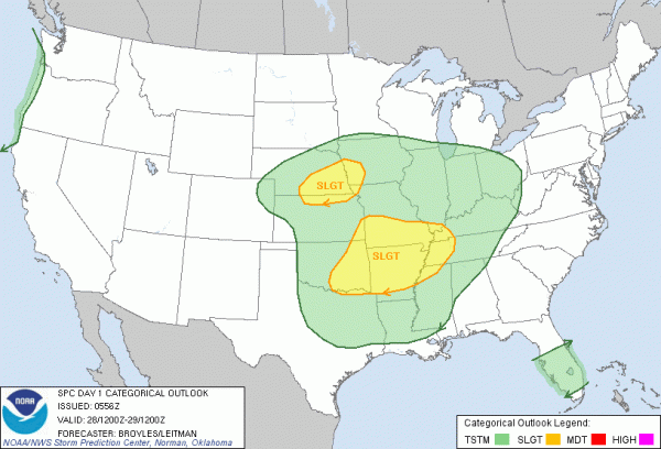
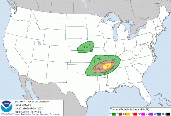
The next story regarding this system is the evolution of severe weather south of the system. There should be enough wind shear, spin, and some instability for this system to produce strong winds, tornadoes, and hail in portions of southeast Nebraska, northern Kansas, eastern Oklahoma, north and central Arkansas, southern Missouri, and western portions of Tennessee and Kentucky. The biggest area of concern for tornado development will be for portions of northeastern Arkansas where the Storm Prediction Center (SPC) has a 10% probability to see a tornado within 25 miles of a point. Residents in these areas should have their severe weather safety plan in place as these storms develop.
Here’s the SPC’s tornado threats showing the percentage of a tornado within 25 miles of a point:

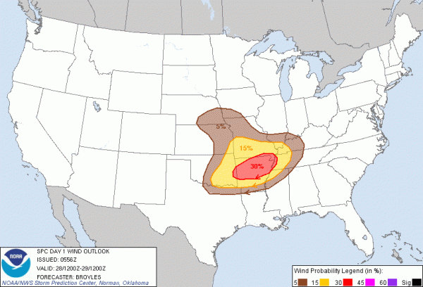
Here is the wind threat for February 28, 2012:

As this system pushes east, it could spread more severe weather east of the Mississippi River for parts of Mississippi, Alabama, Tennessee, North Georgia, Kentucky, Indiana, Illinois, West Virginia, Ohio, South Carolina, and North Carolina. The main threat from these storms will be strong winds and isolated tornadoes. The severe weather threat does not appear too high at this point, but it could be shaky for some areas as these storms push east.
Here’s the slight risk area for February 29, 2012:

After this storm system pushes through, another storm will develop by Friday and Saturday that could bring severe weather across Dixie Valley and possibly for portions of the Ohio River Valley. Personally, I think this upcoming system appears to have better dynamics overall than Wednesday’s system and severe weather is quite likely for portions of the United States along the Mississippi River and points east. Arkansas, Louisiana could encounter a rough patch of severe storms that have a better chance to produce tornadoes. The SPC has yet to outline these areas for severe weather as it is still over four days away.
However, I expect an outline area to occur by Day 3 regarding the severe chances. Some of these storms could produce discrete supercells. Once we get a better idea how Wednesday’s system evolves, we will have a better understanding for the March 2-3, 2012 storm.
Bottom line: The United States will see its share of very active weather this week. Heavy snow, freezing rain, and low visibility is likely across the Northern Plains while severe weather will unfold across the central portions of the country, and it will likely spread to the Southeast on February 29, 2012. Towards Friday and Saturday (March 2-3, 2012), another system will significantly strengthen across the central portions of the United States and could produce a great chance for severe weather. Once Wednesday’s system pushes through, the focus will definitely be on Friday and Saturday.
I believe this storm system has a much higher potential to become potent. Only time will tell, and there’s still a chance that the models could weaken the weekend system. However, the model trends have been showing a stronger storm with better dynamics. This is an excellent week to own a NOAA Weather Radio if you haven’t already got one. If you don’t, go out and buy one (especially if you live in a tornado-prone area). If that is not an option, you can download the iMap Weather Radio Application on Apple devices such as the iPhone and iPad. It is a great program that will notify you if your area is in a severe thunderstorm or tornado warning.
Submit your own Earth or night sky photos at EarthSky Community Photos.


