


What are pyrocumulonimbus clouds?
Most people have heard of cumulonimbus clouds, those towering thunderheads that bring storms with lightning, thunder, heavy rain, hail and sometimes tornadoes. Pyro is a prefix meaning fire. And pyrocumulonimbus clouds are thunderheads that form due to fires.
So when wildfires grow large and intense, they can create their own weather. The heat and smoke from fires can rise into the atmosphere like the updraft in a thunderstorm. As the hot air ascends, it carries smoke, ash and water vapor high into the atmosphere.
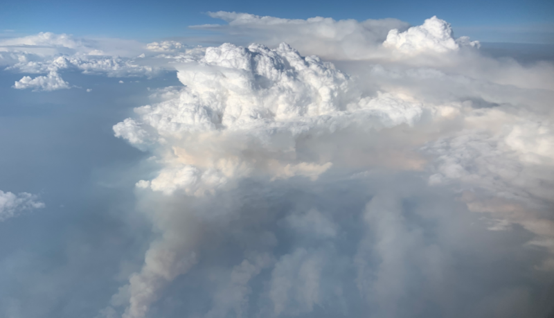
If conditions are right – especially if the atmosphere is unstable – the rising plume can grow into a towering thunderstorm cloud. These clouds look quite similar to cumulonimbus clouds that produce lightning and heavy rain, except for brownish colors at their base. But pyrocumulonimbus clouds are fueled by fire rather than typical atmospheric processes.
Some pyrocumulonimbus clouds can reach heights of 30,000 to 50,000 feet (9 to 15 km)! That’s far above the height most airplanes fly. They can punch through the troposphere (the layer of air closest to Earth where we live) to the stratosphere. They can also spread out into anvil-shaped tops.
And the higher these clouds reach, the more these fires can spread smoke. It’s partly thanks to pyrocumulonimbus clouds that the smoke from wildfires can travel thousands of miles away.
A storm born of fire
Pyrocumulonimbus clouds can start as pyrocumulus clouds. This smaller version of a fire-generated cloud will have a darker, brown-tinged base. Sometimes you can see the fire beneath it, but sometimes the fire is hidden by haze or the terrain.
But as the fire grows, so can the cloud. The hot fire heats the air above, and hot air rises. As the hot air rises, it cools and expands. Water vapor then condenses on the ash. These pyrocumulus clouds can keep growing and building until they reach the pryocumulonimbus stage, which can have all the hallmarks of a thunderstorm. So pyrocumulonimbus clouds can bring rain. But, unfortunately, by that time the cloud has often drifted downwind. So the rain typically falls outside the fire.
And there’s an especially pernicious aspect of pyrocumulonimbus clouds. They can create lightning and thus spark new areas of fire nearby. Plus, the storms can generate strong winds that make the fire situation worse.
In fact, if the conditions are right, the storms that occur with pyrocumulonimbus clouds can even generate a fire tornado. Also known as a fire whirl, fire swirl, fire devil, firenado or fire twister, a fire tornado is a whirlwind induced by a fire and often (at least partially) composed of flame or ash.
In 2018, a firefighter was tragically killed in California when the Carr fire spawned a fire tornado. Read about it here. Or watch incredible video in the news report below.
Smoke in the upper atmosphere can last for months
In 2023, scientists with the National Oceanic and Atmospheric Administration (NOAA) released a study of pyrocumumlonimbus clouds’ effect on Earth’s atmosphere. The study showed that that smoke injected into the upper atmosphere via these clouds can stick around for months. A fire in 2017 in the Pacific Northwest put so much smoke into the atmosphere that remote sensing instruments around the globe monitored it for more than eight months.
Fires that year forced also black carbon and organic carbon into the lower stratosphere. This carbon affected our climate and temporarily cooled the planet.
Joshua Schwarz, a NOAA scientist, said in 2023:
These fire clouds are growing larger and more frequent.
Lead author Joe Katich, who now works for BAE Systems, said that same year:
Pyrocumulonimbus clouds contribute more to the stratospheric makeup than we thought. They act in different ways than we thought and stick around longer than we thought. This finding is important on its own. But it will also help us understand the long-term implications of solar geoengineering with aerosols. [Editor’s note: Geoengineering refers to a range of different activities that humans might undertake with the goal of cooling the Earth or removing certain gases from the atmosphere.]
Bottom line: Pyrocumulonimbus clouds are fire-driven thunderstorms. The storms can produce lightning and strong winds that make the fire situation worse.
Like what you read?
Subscribe and receive daily news delivered to your inbox.
More from
Kelly Kizer Whitt


