


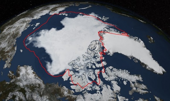
On September 17, 2014 Arctic sea ice coverage reached its annual minimum, according to the NASA-supported National Snow and Ice Data Center (NSIDC) at the University of Colorado, Boulder. This year’s minimum extent is similar to last year’s and below the 1981-2010 average of 2.40 million square miles (6.22 million square km). Meanwhile, in Antarctica, sea ice was at a record high. More about that below.
Over the 2014 summer, Arctic sea ice melted back from its maximum extent in March (which was the fifth-lowest on record) to a coverage area of 1.94 million square miles (5.02 million square kilometers), according to analysis from NASA and NSIDC scientists.
Walter Meier is a research scientist at NASA’s Goddard Space Flight Center in Greenbelt, Maryland. He said:
Arctic sea ice [minimum] coverage in 2014 is the sixth-lowest recorded since 1978. The summer started off relatively cool, and lacked the big storms or persistent winds that can break up ice and increase melting.
Even with a relatively cool year [for the U.S. East and parts of the Arctic], the Arctic ice is so much thinner than it used to be. It’s more susceptible to melting.
This summer, the Northwest Passage above Canada and Alaska remained ice-bound. A finger of open water stretched north of Siberia in the Laptev Sea, reaching beyond 85 degrees north, which is the farthest north open ocean has reached since the late 1970s, according to Meier.
The animation above shows daily Arctic sea ice extent from March 21 to Sept. 17 – when the ice appeared to reach its minimum extent for the year. It’s the sixth-lowest minimum sea ice extent in the satellite era. The data was provided by the Japan Aerospace Exploration Agency.
While summer sea ice has covered more of the Arctic in the last two years than in 2012’s record low summer, this is not an indication that the Arctic is returning to average conditions, Meier said. This year’s Arctic sea ice minimum extent remains in line with a downward trend; the Arctic Ocean is losing about 13 percent of its sea ice per decade.
To measure sea ice extent, scientists include areas that are at least 15 percent ice-covered. The NASA-developed computer analysis, which is one of several methods scientists use to calculate extent, is based on data from NASA’s Nimbus 7 satellite, which operated from 1978 to 1987, and the U.S. Department of Defense’s Defense Meteorological Satellite Program, which has provided information since 1987.
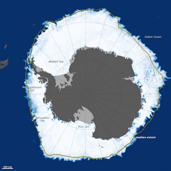
Meanwhile, in Antarctica, sea ice was at a record high. As ice in the Arctic reached its minimum during our northern late summer, sea ice on the other side of the planet was headed in the opposite direction, during the southern late winter. The map above shows Antarctic sea ice on September 19, 2014. While it was not yet possible to determine if the ice had reached its maximum extent for the year, the five-day average had already surpassed 20 million square kilometers (7.70 million square miles) for the first time in the modern satellite record, according to the National Snow and Ice Data Center.
According to NASA, this trend toward increasing sea ice in Antarctica is “not unexpected” under conditions of global warming. Nathan Kurtz, a cryospheric [frozen water] scientist at NASA Goddard told NASA’s Earth Observatory website that many climate models actually predict a short-term increase in Antarctic sea ice. Factors like increasing fresh water and higher wind speeds promote ice growth and expansion—factors that appear to be dominating right now, he said. In the long-term, Kurtz said:
…increasing near-surface air temperatures [in Antarctica] are expected to have the stronger effect and begin to melt the ice and halt the expansion.
Also, although it is true that sea ice around Antarctica has been increasing, it has not been increasing as much as sea ice in the Arctic has been declining. Kurtz noted:
The overall trend of sea ice expansion in the Antarctic is only one-third of the magnitude of the decrease in Arctic sea ice.
Read more about Arctic and Antarctic sea ice in 2014, via NASA Earth Observatory
Read more about melting Arctic sea ice, via NASA News
Bottom line: Arctic sea ice coverage continued its below-average trend this year as ice declined to its annual minimum. This year’s ice coverage is the sixth-lowest since 1978. Meanwhile, sea ice in Antarctica increased to a record high.
Like what you read?
Subscribe and receive daily news delivered to your inbox.
More from
Editors of EarthSky


