


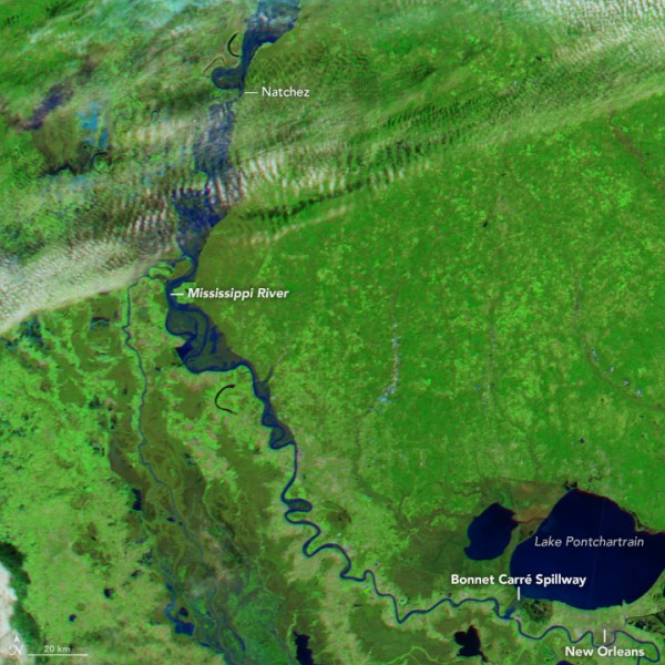
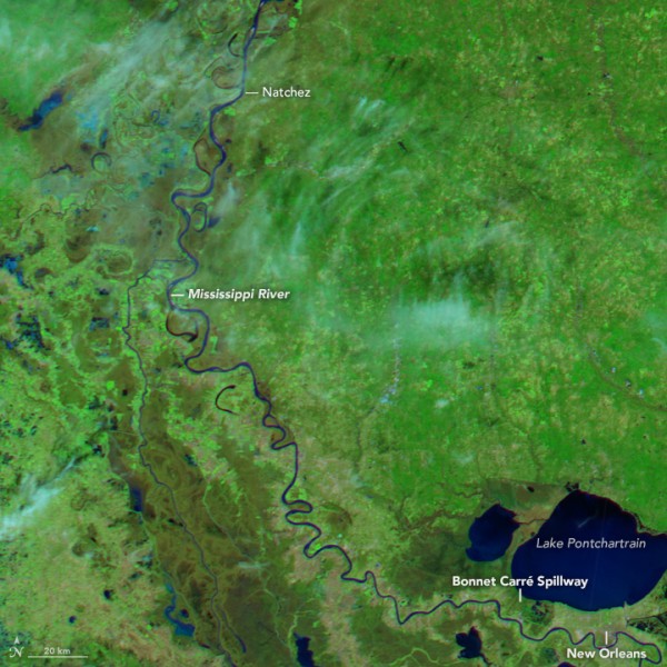
In early January 2016, communities along the southern reaches of the Mississippi River faced severe flooding from rains that fell weeks earlier and well to the north. These two NASA satellite images show the Mississippi River as it runs through southern Mississippi and Louisiana. The above image was acquired on January 11, 2016. The image below shows the river at a normal level last January (January 24, 2015.)
Heavy rains in December 2015 drenched parts of Missouri and Illinois, and the pulse of fresh water has finally reached Louisiana and Mississippi. On January 11, the U.S. Army Corps of Engineers opened the Bonnet Carré Spillway near New Orleans in preparation for the southward-moving pulse of flood water.
Substantial flooding is unusual on the Mississippi River in winter. As reported by Weather Underground, this event was only the second time that a winter flood has made the top-40 list of flood crests at St. Louis in more than 200 years of records. (The other flood occurred in December 1982 during a major El Niño.)
According to John Kimball, a hydrology, ecology, and remote sensing expert at the University of Montana, the soil within the upper Missouri basin remained largely frozen. There was no rapid thaw or snowmelt that helped raise the river’s level. But elsewhere in the Mississippi Basin, precipitation that might typically fall as snow in December and January instead fell as rain. Kimball said:
There has been much higher than normal rainfall over the southern and central portion of the Mississippi basin this winter, attributed to the strong El Niño. This led to soil saturation and more rapid and abundant runoff than in a normal winter.
The saturated ground set the stage for the central and southern Mississippi basin to feel the effects of the approaching flood water.
Over the course of a few weeks, the excess water (with contributions from the Ohio and Missouri rivers) made its way south. When the top image was acquired on January 11, river gauge observations and forecasts for the Mississippi River in Natchez, Mississippi, showed that the river stood at about 16.5 meters (54 feet)—about 2 meters above flood stage—and still rising.
Farther south in Louisiana, the Bonnet Carré Spillway was opened for the 11th time in its history to reduce pressure on levees in southeast Louisiana. The spillway was erected in 1931 to control flooding in the Lower Mississippi Valley by diverting water to Lake Pontchartrain. According to Richard Kesel of Louisiana State University, the Morganza Spillway to the north had not been opened—indicative that flooding was not anticipated to be a huge problem.
Enjoying EarthSky? Sign up for our free daily newsletter today!
Bottom line: Two satellite images show the contrast between the flooded Mississippi River in January, 2016 and the same area last year, when the river was at a normal level.
Like what you read?
Subscribe and receive daily news delivered to your inbox.
More from
Editors of EarthSky


