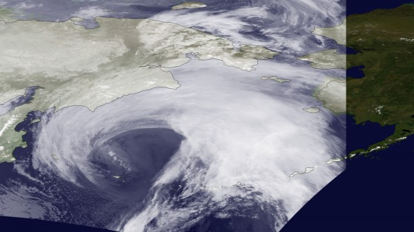
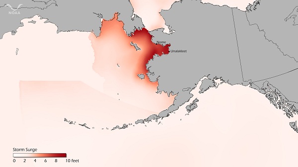
An area of low pressure — 945 millibars — with the strength of a Category 2 or 3 hurricane hit parts of northwestern Alaska late Tuesday, November 8, 2011, and into Wednesday. A system of this epic magnitude storm has never been seen in the state and will likely cause significant damage across portions of northwestern Alaska.

The storm crossed the Chukotsk Peninsula and affected the Bering Strait coast, St. Lawrence Island, Chukchi, Seward Peninsula, and the city of Nome. The storm is bringing blizzard conditions with zero visibility, storm surge of ten feet, and winds as high as 100 miles per hour. The National Weather Service at Fairbanks, Alaska has described this storm as an “extremely dangerous and life-threatening storm of an epic magnitude rarely experienced”.

The most unusual aspect of this storm is the intensity and track. The storm is pushing further north than what many low-pressure systems typically do this time of year. The powerful area of low pressure, with a pressure of 945 mb, is another huge area of concern. In the map above, it shows a tight pressure gradient around the low. The circles, also known as isobars, are tightly compacted together, indicating very strong winds with this system. Isobars are simply lines of equal pressure. When pressure lowers, the storm becomes stronger. A pressure reading of 945 mb is the typical strength of a Category 3 or 4 hurricane. Sustained winds of 75 mph with gusts over 100 mph were expected in this region. Temperatures are below freezing with many places in the 20’s. Heavy snow and blizzard conditions are blinding residents across northwest Alaska.
The National Weather Service issued this statement ahead of the storm:
ALASKA WEST COAST TO BE HIT BY ONE OF THE MOST SEVERE BERING SEA STORMS ON RECORD…A POWERFUL AND EXTREMELY DANGEROUS STORM OF NEAR RECORD OR RECORD MAGNITUDE IS BEARING DOWN ON THE WEST COAST OF ALASKA. AT 9 AM THIS MORNING THE STORM CENTER WAS LOCATED ABOUT 600 MILES SOUTHWEST OF ST LAWRENCE ISLAND. THE STORM IS FORECAST TO MOVE RAPIDLY NORTHEAST TODAY AND TONIGHT WITH THE CENTER MOVING ACROSS THE CHUKOTSK PENINSULA TONIGHT. ON WEDNESDAY THE STORM WILL TAKE A NORTHWESTWARD TRACK INTO THE CHUKCHI.
THIS WILL BE EXTREMELY DANGEROUS AND LIFE THREATENING STORM OF AN EPIC MAGNITUDE RARELY EXPERIENCED. ALL PEOPLE
IN THE AREA SHOULD TAKE PRECAUTIONS TO SAFEGUARD THEIR LIVES AND PROPERTY.

Storm surge is a huge concern for parts of Alaska. Storm surge of ten feet is expected across northwest Alaska. Severe beach erosion and major coastal flooding will occur. The NWS warns residents of Kivalina that they are extremely vulnerable to damage caused by these factors. Ice could be pulled onto shore at Norton Bay due to the strong surf and winds associated with this storm. Storm surge is more worrisome because of the decreasing amounts of ice across the region.
The last time a storm of similar magnitude hit Alaska was in 1974. During this time, the sea surface was more frozen and was covered with more ice. When the storm pushed in, a lot of the ice subdued the strong storm surge. However, we are no longer living in 1974. 2011 has brought melting ice caps throughout the Arctic, and ice extent is much lower now. With this in mind, storm surge is a major concern for the coastal areas across Alaska.
All residents are urged to stock up on supplies and to stay indoors for survival. They have set up shelters to help house residents in the area. Snowfall totals are likely to exceed 12 inches, and the strong winds will create zero visibility. With the combined elements of storm surge, beach erosion, coastal flooding, strong winds, and blowing snow, the NWS used strong language to make sure the public understands the seriousness of the situation. It is practically like going through a hurricane with snow instead of heavy rain.
Bottom line: A strong storm with the strength of a Category 2 or 3 hurricane pushed through Alaska Tuesday evening on November 8, 2011. Storm surge of 10 feet and coastal flooding are expected across northwest Alaska as the storm continues to move to the east. Sustained winds of hurricane force around 75 mph are likely in some areas, with gusts as high as 100 mph. Blizzard conditions inland will create zero visibility, and all residents are urged to stay inside until after the storm leaves later today. This will likely be one of the worst storms ever to hit Alaska and could break a lot of records. 2011- what a year!


