


If the 2015–2016 El Niño is representative of El Niño events of the past, it has probably reached its peak, according to a NASA report on January 22, 2016. Warmer-than-average waters in the eastern tropical Pacific Ocean should start to cool off and shift westward. By summer, the tropical Pacific might be back in a neutral state or La Niña cooling could kick in, as it did after major El Niños of the past.
But will the ocean respond in 2016 the way it did after the strong El Niños of 1998 and 1983? Given that the planet is hotter than at any time in the past 135 years, say scientists, there are no guarantees.
Water temperatures in the Niño3.4 region of the tropical Pacific — an area that is usually the focal point of such events — broke a record in December 2015, according to researchers from the National Oceanic and Atmospheric Administration (NOAA) Sea surface temperatures averaged 2.38° Celsius above the norm, surpassing December 1997, which was 2.24°C above normal. For October through December 2015, the three-month temperature average for the Niño3.4 region was equal to the record high from the same months in 1997.
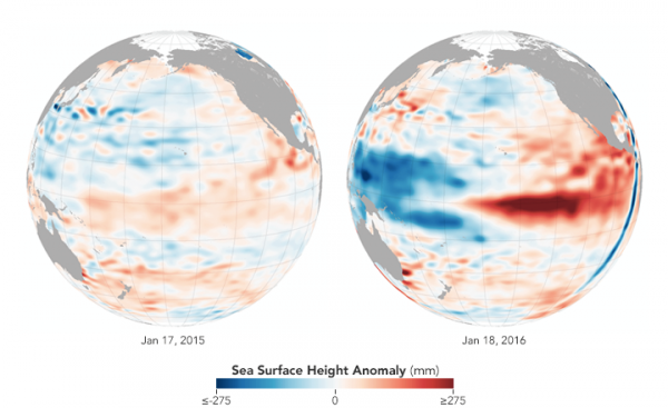
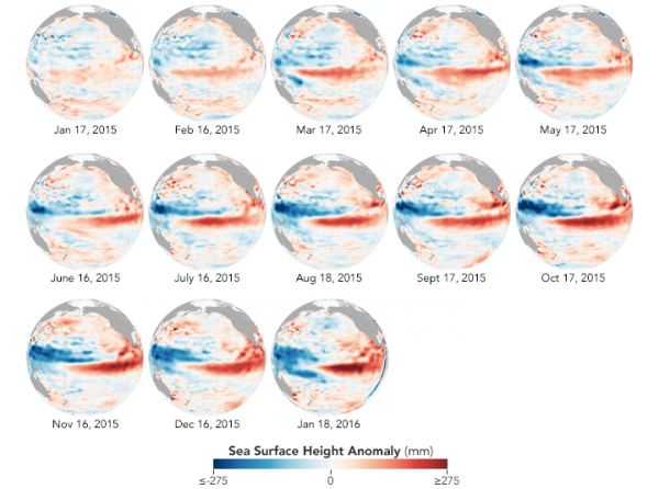
The data maps above used satellite measurements to compare sea surface heights in the Pacific Ocean as measured by NASA on January 17, 2015, before the El Niño event began, and on January 18, 2016. Note that the January 2015 map shows remnants of a weak 2014 El Niño event that kick-started the intense 2015–2016 event.
Shades of red indicate where the ocean stood higher than the normal sea level; warmer water expands to fill more volume. Shades of blue show where sea level and temperatures were lower than average (water contraction). Normal sea-level conditions appear in white.
Tony Busalacchi, an oceanographer at the University of Maryland, noted that precipitation has so far “followed the classic El Niño patterns” observed in the 1997–98 and 1982–83 events. For instance, in the southern United States, the winter has been cooler than normal and quite wet. The Pacific Northwest has also been soaked by rain and snow storms. Across the Pacific, Indonesia and other areas have been dry. Busalacchi said:
It has been another ‘event of the century’ much like the one we just had in 97–98. The question is: will this event bring California and other western areas out of drought? And how quickly will we flip into La Niña?
Bill Patzert, a climatologist at NASA’s Jet Propulsion Laboratory, sees the potential for a second peak for this El Niño. He pointed to a recent relaxation in the trade winds and a west wind burst that could refuel the warming trend in the eastern Pacific. Weaker trade winds in the eastern Pacific allow west wind bursts to push warm waters toward the Americas. Patzert suspects February and March 2016 could still be very active months for El Niño-driven weather along the western coasts of the Americas.
Enjoying EarthSky? Sign up for our free daily newsletter today!
Bottom line: According to a January 22, 2016 report, the 2015–2016 El Niño might have reached its peak. But because 2015 was such a hot year, scientists say, there are no guarantees.
Like what you read?
Subscribe and receive daily news delivered to your inbox.
More from
Editors of EarthSky


