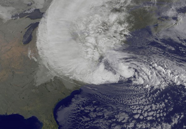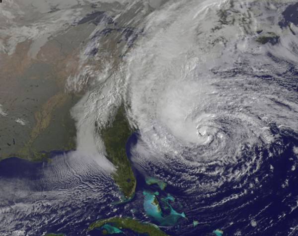
Check out this amazing satellite loop of Hurricane Sandy
UPDATE: October 29, 2012 at 1 p.m. EDT (17 UTC)
Hurricane Sandy’s effects are being felt on the U.S. mainland, and the storm is looking increasingly big and scary. The barometric pressure continues to fall as Sandy taps into the warm Gulf Stream that flows parallel to the U.S. East Coast. Sandy is gaining strength due to the large trough to the west of the storm. Winds have now increased to 90 miles per hour with an official pressure reading of 943 millibars (mb). Remember, the lower the pressure, the stronger the storm. This reading gives Sandy the lowest pressure reading ever recorded north of Cape Hatteras. We are already seeing significant problems occurring from Sandy, and the storm is still roughly 200 miles southeast of New Jersey and 260 miles southeast of New York City. The center of Sandy is expected to make landfall this evening along or just south of the southern New Jersey coast.
Meteorologist Brad Panovich from Charlotte, North Carolina tweeted:
It’s not hype, not an over reaction… this is the worst storm in our lifetimes. Maybe by quite a bit too, please heed all warnings. #Sandy
Currently, parts of Atlantic City are officially under water. Here is an image of the flooding occurring there:
As of 11 a.m. EDT (15 UTC), NWS Buoy 44025, located about 30 nautical miles south of Long Island, is reporting wave heights of 23 feet (7 meters). Meanwhile, there are already reports from buoys southwest of the center of the storm of wind gusts around 115 knots, or 130 miles per hour! Sandy has a pressure reading typically seen in a Category 4 hurricane, and will likely have wind speeds of a Category 2 hurricane. This is a serious situation, because the large size and gradual intensification of the storm will only make the storm surge and flooding more severe. The situation is deteriorating fast.
In West Virginia, Sandy is producing winter weather. Winter storm warnings and blizzard warnings have been issued, and snowfall totals could easily top 2 to 3 feet (about a meter) in the higher elevations. The image below is the NAM model that shows the snowfall potential in the next 84 hours.
Meanwhile, another region that Sandy will affect in a big way is across the Great Lakes. According to the National Weather Service, waves on Lake Michigan could be 10 to 18 feet (3 to 6 meters) by this afternoon, then build to 20 to 33 feet (6 to 9 meters) on Tuesday before subsiding. Waves on parts of Lake Superior and Lake Huron could top 20 feet.
In summary, everyone east of the Mississippi River will experience something from Hurricane Sandy. In the southeast, windy conditions are bringing trees down and knocking power out in a few areas. Stay tuned for updates on Hurricane Sandy as they come available. Sandy is expected to make landfall later this evening around 7-9 p.m. EDT (23 UTC – 1 UTC on October 30). The storm is speeding up, so it could make landfall as early as 5 or 6 PM EDT. What makes matters worse, is that high tide is going to occur at nearly the same time as landfall. It is only going to get worse before it gets better, and many people will likely experience no power for over a week. Stay safe, and listen to local authorities.
Original post on October 28, 2012:
Hurricane Sandy is the major weather story circulating the globe at present, and it has every right to be. The overall meteorological setup for Sandy is extremely rare. We are not just dealing with a large hurricane. We are dealing with a hurricane that is developing extratropical characteristics and becoming a mid-latitude cyclone. In most hurricanes, the strongest winds are located near the center (eyewall), but not in Sandy. Instead of storing all of the energy near the center of the storm, Sandy’s wind field has continuously expanded throughout the past 48 hours. Tropical storm force winds (39 miles per hour or higher) extend outwards over 500 miles! All of this energy is what truly alarms me. It means, for instance, that storm surge will be much greater. Also, we are talking about millions of people in the Mid-Atlantic and New England who will likely lose power and who will have strong winds in their vicinity for 24 to 48 hours. Sandy is a large and violent storm that everyone should take seriously. This is not your typical nor’easter or weak Category 1 hurricane. Meteorologists will surely be talking about this storm for many decades.

Hurricane Sandy is already responsible for killing 65 people in the Caribbean, with the largest death toll occurring in Haiti (51 deaths). A state of emergency has already been issued by a large majority of the states that will be affected by Sandy between now (Sunday, October 28 at 8 p.m. EDT) through Monday night. According to Accuweather, tropical storm force winds from the northeast to southwest side of Sandy stretch approximately 900 miles. To give you an idea how massive Sandy truly is, 900 miles is roughly the distance from New York City to Daytona Beach, Florida. High wind warnings, wind advisories, blizzard warnings in West Virginia, and so on, span the U.S. East Coast. It is extraordinary and almost impossible to try to comprehend so many weather events occurring all at once across these states.
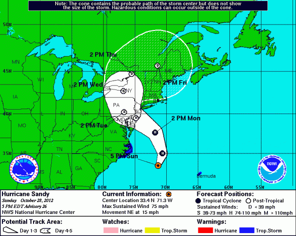
Here is the latest forecast track of Hurricane Sandy:

Rainfall potential for the next five days (Starting on October 28 through November 2, 2012):
If you live in this region, you should be nearly finished preparing for this storm. This is a serious situation, and I strongly urge everyone to take this storm seriously. If you are told to evacuate, do it. Do not stick around. Sandy is a storm that we have never seen before, and, by the way, it does not compare to the Perfect Storm of October 1991. If you live in the U.S. East, your weather will continue to decline during the overnight hours Sunday night and deteriorate significantly throughout Monday, October 29, 2012.
Here are a few things I believe people should understand and realize regarding Sandy:
1) This storm will not be similar to Hurricane Irene from 2011. It will be more powerful and cause a lot more damage. This will easily be a billion-dollar disaster.
2) Sustained tropical storm force winds of 39 mph to 73 mph will occur for a long period of time. Residents across the Mid-Atlantic and New England will experience these winds for over 24 hours. A wind gust of 64 mph was already recorded in coastal North Carolina earlier today, and the storm is no where close to them!
3) The main threat from Sandy is water. All forms of it including storm surge, flooding, and snow. With the addition of a full moon, ocean tides will be significantly higher than usual. Flooding is a huge concern, and unfortunately, it looks inevitable. Storm surge could easily exceed 6-11 feet in New York City, which could result in one of the biggest coastal flooding events in the city.
4) The exact landfall of Sandy is not important because the effects of Sandy will be far reaching. However, it is important to note that anyone on the north side of the center of circulation will experience the strongest storm surge as winds will be pushing onshore.
5) Residents in West Virginia will be experiencing the winter aspect of this storm. Blizzard warnings have already been issued, and some areas could see up to two feet of snow.
6) The lower the pressure, the stronger the storm. Sandy currently has a barometric pressure around 952 millibars. This is very low. To give you an idea, pressure readings around 950 mb are typically seen in Category 3 hurricanes. Our computer models are hinting that the pressure could drop between 940-950 mb by tomorrow afternoon. You never want to see a storm strengthen prior to making landfall.
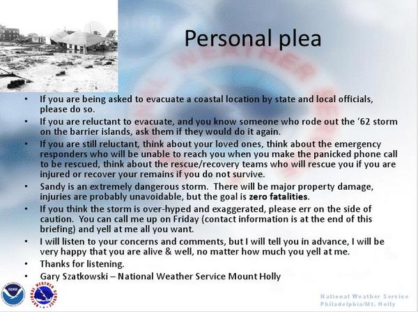
Many meteorologists have already shared their opinions on Hurricane Sandy. In fact, the local offices at the National Weather Service are increasing their wording in their discussions to the public. For instance, Meteorologist Gary Szatkowski posted this slide:

Bottom line: Hurricane Sandy – due to effect the U.S. Mid-Atlantic states and New England beginning Sunday night and through Monday, October 29 – is a large storm that will impact millions. Power outages, flooding, and wind damage is inevitable. Sandy could strengthen prior to making landfall, and many areas will experience winds gusting over 75 mph. Flooding and storm surge will be a major story, and beach erosion will be significant. In West Virginia, this storm will produce heavy snow and strong winds that will create nasty blizzard conditions. Stay safe, be prepared, and if you are told to evacuate, do it. We’ll have more updates about Hurricane Sandy as it continues to push closer to the eastern coast of the United States. Please stay safe!


