


Earlier this month (April 10), Philip J. Klotzbach and William M. Gray, the forecasting team from Colorado State University (CSU) released their seasonal Atlantic hurricane outlook for 2013. Based on the current trends and observations from this past winter, Klotzbach and Gray are predicting 2013 could be a very active season with an above average chance for a major hurricane to hit the United States coast or the Caribbean.
This is CSU’s 30th year releasing a hurricane outlook. Their projections have been fairly accurate over the past several years. Last year, their April forecast for the 2012 Atlantic hurricane season was for a below average year with 10 named storms. But that did not verify because an El Niño never formed, which resulted in 19 named storms in the Atlantic. Seasonal outlooks this early can change, but all of the signs are pointing towards an above average season in the Atlantic for 2013.

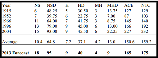
Klotzbach and Gray are predicting 18 named storms, nine hurricanes, and four major hurricanes for the 2013 Atlantic Hurricane Season. A typical Atlantic hurricane season averages 12 named storms, 6.5 hurricanes, and two major hurricanes. It is important to note that a major hurricane is classified as a storm at or stronger than a Category 3 storm with wind speeds over 111 miles per hour. In their latest release, CSU is issuing a 72% probability that a major hurricane will hit parts of the U.S. coastline. They are forecasting a 61% probability that a major hurricane will strike parts of the Caribbean in 2013. They believe an active season will develop thanks to an anomalously warm tropical Atlantic and a low likelihood that an El Niño will develop this summer.

What to look at when making early season hurricane outlooks
When it comes to making preseason forecasts for an upcoming hurricane season, it is important to analyze analog years and weather patterns that have developed in the past. For instance, meteorologists look at trends in weather patterns, ocean temperatures, and steering currents to predict how active a hurricane season can truly be. They can also look at past years, or analogs, that can show how certain weather patterns influenced that particular season. For instance, we already know that an El Niño year typically produces fewer named storms in the Atlantic, thanks to an increase in wind shear that helps disrupts storms from developing. As of today, the ENSO, or El Niño Southern Oscillation, is neutral. This means that an El Niño or La Niña conditions appear unlikely. This past hurricane season in 2012 brought neutral ENSO conditions, and we saw an active season. There are many elements that can possibly change this outlook, but the patterns are there. It is important to note that it only takes one storm to make a hurricane season huge. For instance, if Hurricane Sandy never formed in 2012, would anyone still remember the actual season? In 1992, we had a very quiet season, but Hurricane Andrew developed and made that year memorable.
Bottom line: Philip J. Klotzbach and William M. Gray from Colorado State University (CSU) released their April outlook for the 2013 Atlantic Hurricane Season. They predict a well-above-average year, thanks to warmer sea surface temperatures and the likelihood that the ENSO state will remain neutral during the summer and fall. Their early season predictions last year (2012) were off dramatically, as their forecast for 10 named storms verified at 19 named storms. The difference between this year and last year is that in 2013 we will have a higher probability to see stronger hurricanes that could ultimately impact the U.S. coast, they believe. CSU and NOAA will issue their official forecasts for the 2013 Atlantic Hurricane Season near the end of May and first week of June 2013.
Like what you read?
Subscribe and receive daily news delivered to your inbox.
More from
Matt Daniel


