


An international team of scientists used magnetic satellite data together with data from aircraft to reveal how Antarctica was linked to its ancient neighbors – today’s Australia, India and South Africa – as part of the ancient Gondwana supercontinent. The team used their findings, published in the journal Scientific Reports on March 9, 2021, to create an animation that pieces together, like a jigsaw puzzle, the way these large sections of Earth’s crust moved over millions of years.
Gondwana was an amalgam of continents that incorporated South America, Africa, Arabia, Madagascar, India, Australia, New Zealand and Antarctica. Scientists think that Gondwana formed around 600-500 million years ago, when large pieces of Earth’s crust – called the tectonic plates – collided and built huge mountain ranges comparable to today’s Himalayas and Alps. Gondwana started to break up about 180 million years ago, ultimately leaving Antarctica stranded and isolated at the South Pole, and covered in ice for around 34 million years.
Kiel University’s Peter Haas is a co-author of the study. He said in a statement:
Using the new magnetic data, our animation illustrates how the tectonic plates have moved over millions of years after the breakup of Gondwana.
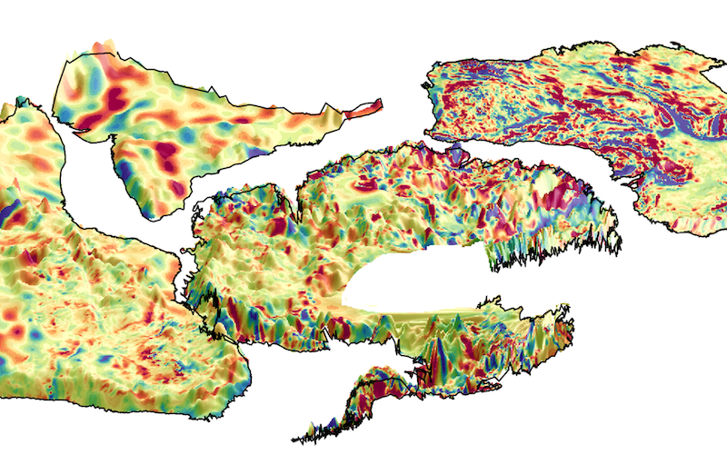
The fact that Antarctica is about as remote as you can get and the land below is covered by a massive ice sheet makes collecting geophysical information both challenging and expensive, said the scientists. Fortunately, satellites orbiting above can see where humans cannot. The team – from Germany’s Kiel University, South Africa’s Witwatersrand University, and the British Antarctic Survey and National Institute of Oceanography and Applied Geophysics – used magnetic data from ESA’s Swarm satellite mission along with aeromagnetic data from aircraft over southern Africa, Australia and Antarctica.
Jörg Ebbing, of Kiel University, is the study’s lead author. He said in a statement:
With the available data, we only had pieces of the puzzle. Only when we put them together with satellite magnetic data, can we see the full picture.
Study co-author Fausto Ferraccioli is a geophysicist at the National Institute of Oceanography and Applied Geophysics in Italy. Ferraccioli said:
We have been trying to piece together the connections between Antarctica and other continents for decades. We knew that magnetic data play a pivotal role because one can peer beneath the thick Antarctic ice sheet to help extrapolate the geology exposed along the coast into the continent interior.
But now we can do much better. With the satellite and aeromagnetic data combined, we can look down deeper into the crust. Together with tectonic plate reconstructions, we can start building tantalizing new magnetic views of the crust to help connect geological and geophysical studies in widely separated continents. Ancient cratons (stable continental platforms) and orogens (folded mountain belts) in Africa, India, Australia and East Antarctica are now better connected magnetically than ever before.
Bottom line: A new study reveals how Antarctica was linked to its ancient neighbors – today’s Australia, India and South Africa – as part of the ancient Gondwana supercontinent. The research team used their findings to create an animation that pieces together the way these large pieces of Earth’s crust moved over millions of years.
Source: East Antarctica magnetically linked to its ancient neighbours in Gondwana
Like what you read?
Subscribe and receive daily news delivered to your inbox.
More from
Eleanor Imster


