


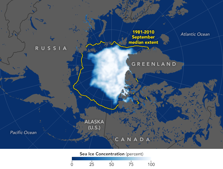
The Arctic sea ice cap is a huge expanse of frozen seawater floating on top of the Arctic Ocean and neighboring seas. The Arctic is frozen water, in other words, unlike the Antarctic, which is an actual continent covered by ice. Every year, Arctic sea ice expands and thickens during fall and winter and grows smaller and thinner in spring and summer. This year’s Arctic sea ice minimum is believed to have come on September 18, 2019, at 1.6 million square miles (4.15 million square km) unless, unexpectedly, the ice cap gets smaller still. If September 18 was indeed the sea ice minimum for 2019, this year’s minimum is in a three-way tie – with 2007 and 2016 – for second-lowest minumum since modern record-keeping began in the late 1970s, according to NASA and the National Snow and Ice Data Center (NSIDC).
The lowest Arctic sea ice minimum ever recorded was in 2012, when the ice cap shrank to 1.32 million square miles (3.41 million square km).
In recent decades, increasing temperatures have caused marked decreases in Arctic sea ice in all seasons, with particularly rapid reductions in the minimum end-of-summer ice extent. The shrinking of the Arctic sea ice cover can ultimately affect local ecosystems, global weather patterns, and the circulation of the oceans.
Changes in Arctic sea ice cover have wide-ranging impacts. The sea ice affects local ecosystems, regional and global weather patterns, and the circulation of the oceans.
Claire Parkinson is a climate change senior scientist at NASA’s Goddard Space Flight Center in Greenbelt, Maryland. She said in a statement:
This year’s minimum sea ice extent shows that there is no sign that the sea ice cover is rebounding. The long-term trend for Arctic sea ice extent has been definitively downward. But in recent years, the extent is low enough that weather conditions can either make that particular year’s extent into a new record low or keep it within the group of the lowest.
Why does sea ice matter? Here’s an explanation from Climate.gov:
Arctic sea ice is as fundamental to the environment and ecosystems of the Arctic as trees are to the Amazon Rainforest. Since 1979, ice extent has shrunk by 40 percent, and the loss is transforming Alaska’s climate, accelerating coastal erosion, reducing walrus and other marine mammal habitat, changing the timing and location of blooms of the food web’s microscopic plant life, and lowering survival rates for young walleye pollock—the nation’s largest commercial fishery.
Mark Brandon, polar oceanographer at Open University, wrote in The Conversation:
Sea ice is declining rapidly, and an ice-free Arctic ocean will become a regular summer occurrence as things stand. Indigenous peoples who live in the Arctic are already having to change how they hunt and travel, and some coastal communities are already planning for relocation. Populations of seals, walruses, polar bears, whales and other mammals and sea birds who depend on the ice may crash if sea ice is regularly absent. And as water in its bright-white solid form is much more effective at reflecting heat from the sun, its rapid loss is also accelerating global heating.
Bottom line: The Arctic sea ice minimum extent for 2019 was 1.6 million square miles (4.15 million square km), This minimum is tied for 2nd-smallest in the satellite record.
Like what you read?
Subscribe and receive daily news delivered to your inbox.
More from
Eleanor Imster


