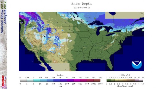
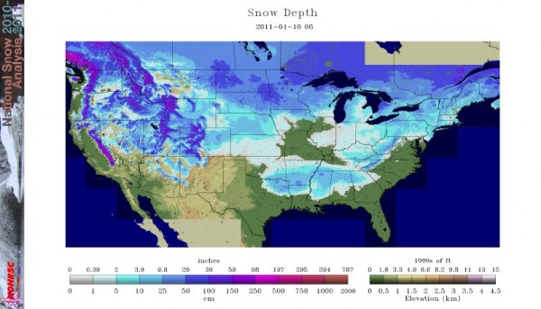
Most of the United States has seen very little snow this winter. In fact, it seems as if Alaska is trying to make up for all of the lack of snow across the other 49 states. As of yesterday, only 14.7% of the nation is covered in snow. At this same time last year, 61.7% of the nation was covered in snow and ice. What a difference a year makes!
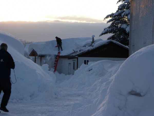
The overall pattern has been set up for Alaska to receive brutally cold temperatures and strong storm systems. These two are a bad mix as they can produce widespread snow across Alaska. Some areas have already seen snowfall totals for this winter reach over 200 inches in some spots. Many houses have experienced collapsed roofs due to so much snow. Temperatures have been amazingly cold since November of 2011. Temperatures around -30°F to -40°F (-30°C to -40°C) have been common across Alaska this winter as the weather pattern has prevented that cold air from moving south out of the state.
Take a look at the current snowfall across the lower 48 in the United States on January 10, 2012:

Now, take a look at the lower 48 on January 10, 2011. What a difference!

The current weather pattern just does not promote cold and snow across the lower 48, although in my previous post, I hinted at a pattern change that could change that. With low pressure systems hitting Alaska, the cold and snow has been staying there. However, if ridging builds into the area, it could temporarily block storms and record cold from hitting the state, and thus providing that cold air to push south into Canada and the lower 48. As of yesterday, here were the current temperatures across these Alaskan cities:
Bettles -42°F
Fairbanks -35°F
McGrath -40°F
Nome -6°F
Northway -22°F

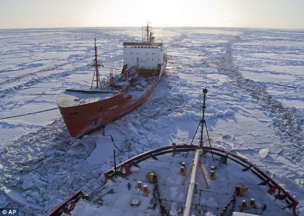
These cold temperatures have caused issues across the Bering Sea in Alaska. Ships are having a difficult time pushing through the sea as a lot of the water is frozen across the region. Many Russian tankers have been trying to provide much needed supplies and fuel to parts of Nome, Alaska. However, the thick ice has caused these tankers to move very slowly. The massive storms have literally prevented the city of Nome, with a population of 3,500 people, from getting supplies from these tankers as the thick ice has caused major delays. The ship holds over a million gallons of diesel fuel and 300,000 gallons of unleaded gasoline. According to the Daily Mail, the tanker can only move about five to six nautical miles a day, and it currently has around 300 miles of sea ice to navigate through before it reaches Nome.

Alaska is known for the cold and snow, but enough is enough. According to the Capital Weather Gang, “Anchorage is off to its snowiest winter on record with more than 80 inches so far. To its southeast, the snow depth around Prince William Sound reached nearly 60 inches in spots late last week, before rain packed it down some over the weekend.” Cordova, Alaska has activated their Emergency Operations Center after the city declared a Disaster Declaration requesting the state to provide needed supplies and shelter for residents. Avalanches, collapsed roofs, and impassible roads have literally shut down the city. Damage estimates for the area are estimated to be around two to three million dollars. The city of Valdez has experienced 252 inches of snow (estimated around 21 feet) this winter. Valdez typically averages around 320 inches every winter, but that average will likely be exceeded as winter continues for another two months. Anchorage, Alaska has seen more than 80 inches of snow across the area. Snowfall totals have been impressive across the state, and the cold temperatures are not allowing any of it to melt.
In the lower 48, snowfall has been minimal. However, in the next two weeks, snowfall totals should increase, especially across the northern portions of the United States as cold air finally pushes south. Areas across western Texas and the mid Atlantic states saw a little bit of the snow on January 9, 2012. Here’s an image of the National Monument as visibilities were reduced in the area from light to moderate snow:

Overall, Alaska has seen a lot of snow and very cold temperatures. Many areas are measuring snow in feet than inches, and some places are in need of supplies and shelter. The weight of the snow is collapsing roofs, and causing avalanches in other areas. A weather pattern change could slowly occur over time, which could help warm and dry out Alaska. The cold air and snow bottled up across Alaska and the North Pole will likely push southward into the lower 48. Many areas that should have snow are currently without any. However, with the pattern change developing, the northern third of the United States will likely begin to feel like winter for the first time this season. If you can recall, unusually warm temperatures that broke records occurred all across the United States last week. As of now, this winter has been the complete opposite of last winter. We had 61.7% of the nation covered in snow back in 2011. This year, only 14.7% of the United States has measurable snowfall. I expect that number to increase during the next 30 days.


