


The death toll is still rising from the powerful 7.9-magnitude earthquake – an extremely strong earthquake – in Nepal today (April 25, 2015). Hundreds are reported to have died from the quake so far, which wrecked many historic buildings. USGS originally reported the quake at a 7.5-magnitude and later upgraded this estimate. The quake took place at 6:11 UTC (1:11 a.m. CDT). This powerful quake’s tremors were felt across the region, and into neighboring India, Pakistan and Bangladesh. The quake struck between the capital Kathmandu and the city of Pokhara about 120 miles (200 km) away. At least one strong aftershock (6.6 magnitude) has already occurred, with many smaller aftershocks, and more are expected.
– Nepali minister reports “massive damage” at the epicenter.
– Preliminary death toll at 686 at 7:30 a.m. CDT (1230 UTC), according to the New York Times.
– Eight bodies recovered from Mount Everest after an avalanche triggered by the quake in Nepal.
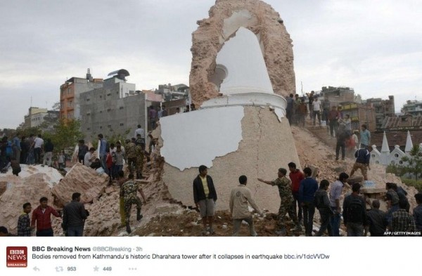
– The landmark Dharahara tower is among buildings reduced to rubble in Kathmandu.
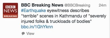
Get continuous updates from the BBC on the scene at the quake location
Journalist Siobhan Heanue, of ABC News Australia, was in Kathmandu when the quake struck. She tweeted the following shocking before-and-after images:
I took these photos an hour apart. Was wandering when quake demolished temples before my eyes. Heartbreaking. pic.twitter.com/RYtIZI4725
— Siobhan Heanue (@siobhanheanue) April 25, 2015
The magnitude 7.9 earthquake that hit Nepal today was the result of a collision of great land plates on Earth. This process has caused deadly quakes in the past, including the 2005 Kashmir earthquake (7.6-magnitude) that killed over 80,000 people.
At the same time, according to USGS, just four events of magnitude 6 or larger have occurred within 150 miles (250 km) of the April 25, 2015 earthquake over the past century.
Details of the quake from USGS are as follows:
Time
2015-04-25 06:11:26 (UTC)
Translate to your time zone
Nearby Cities
34km (21mi) ESE of Lamjung, Nepal
58km (36mi) NNE of Bharatpur, Nepal
73km (45mi) E of Pokhara, Nepal
76km (47mi) NW of Kirtipur, Nepal
77km (48mi) NW of Kathmandu, Nepal
See a list of recent, significant earthquakes from USGS
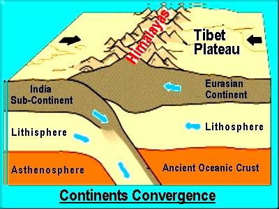
Why do such powerful earthquakes occur in this region? Nepal sits on a part of Earth where one of our planet’s great land plates – called the India plate by scientists – is pushing beneath another (the Eurasia plate to the north). At the location of this earthquake, the India plate is converging with Eurasia at a rate of 45 mm/year towards the north-northeast, driving an uplift of the Himalayan mountain range. For example, Mount Everest – highest mountain on Earth – is still growing taller at a fraction of an inch (3-5mm) per year. USGS said:
The preliminary location, size and focal mechanism of the April 25 earthquake are consistent with its occurrence on the main subduction thrust interface between the India and Eurasia plates.
USGS also said that – although located at a major plate boundary with a history of large-to-great sized earthquakes – large earthquakes in this region are rare in the documented historical era.
Just four events of M6 or larger have occurred within 250 km of the April 25, 2015 earthquake over the past century. One, a M 6.9 earthquake in August 1988, 240 km to the southeast of the April 25 event, caused close to 1500 fatalities. The largest, an M 8.0 event known as the 1934 Nepal-Bihar earthquake, occurred in a similar location to the 1988 event. It severely damaged Kathmandu, and is thought to have caused around 10,600 fatalities.
Enjoying EarthSky so far? Sign up for our free daily newsletter today!

Bottom line: A powerful earthquake struck Nepal – between the capital city of Kathmandu and Pokhara – at 6:11 UTC (1:11 a.m. CDT) on April 25, 2015. Hundreds dead and many historic buildings collapsed.
Like what you read?
Subscribe and receive daily news delivered to your inbox.
More from
Deborah Byrd


