


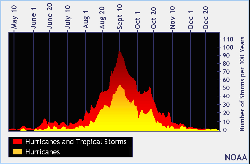
The 2011 Atlantic hurricane season is halfway over, but we are now entering the most active time of the year for tropical cyclone formation. The peak of the season is from mid-August to late October. The season officially ends on November 30, but we can still see tropical cyclone formation after that – as in the 2005 season.
As of now in 2011, we have seen 14 named storms, two hurricanes, and two major hurricanes. The NOAA forecast from August had a forecast of 14 to 19 named storms, seven to 10 hurricanes, and three to five major hurricanes (winds over 111 miles per hour). At this rate, we will likely beat the number of named storms, but the seven to 10 hurricanes will be a challenge. So far this year, it looks like wind shear and dry air has been a major problem for developing cyclones. As I have mentioned in previous posts, wind shear and dry air are two things that weaken tropical systems. These two features are what disrupted the organization of Hurricane Irene that dumped heavy rain across New England, and explain why Irene hit North Carolina as a Category 1 storm instead of a Category 3 storm as originally forecast by the National Hurricane Center (NHC).
On an average season, we typically see 11 named storms, six hurricanes, and two major hurricanes. Back in 2005, the most active hurricane season ever recorded, there were 28 named storms, 15 hurricanes, and seven major hurricanes. During this time in 2005, the Atlantic had 15 named storms, with Hurricane Ophelia in the Atlantic. If we could get another named storm, we would tie 2005 with the number of tropical systems in the Atlantic for this time of year. Still, although there are comparisons to 2005, 2011 is nothing like 2005.
We measure the power of cyclones through “accumulated cyclone energy” – ACE. It is a calculation used to determine how much energy a tropical system contains in its lifetime. Systems that form in the eastern Atlantic typically have higher ACE numbers because they have a longer duration and can develop into major hurricanes. The ACE total for 2005 was set around 248, compared to this year’s ACE total of around 60. The higher the number, the larger the ACE total. We have not seen a lot of hurricanes – this is why our ACE total is so low. Note: tropical storms produce less energy than hurricanes.
Currently in the Atlantic Basin, we are monitoring three systems: Katia, Maria, and Nate. Hurricane Katia is currently a Category 1 hurricane with 85 mph sustained winds, and it’s moving northeast away from the United States and Bermuda.
Tropical Storm Nate is currently spinning away in the Bay of Campeche, upwelling colder water to the surface of the ocean. When a storm such as Nate barely moves, these cooler waters being brought up from deeper in the ocean weaken the system. As of now, Nate has sustained winds of 65 mph and is forecast to strengthen into a hurricane by Saturday or Sunday before it pushes west into portions of Mexico. The chances of Nate pushing northward into the Gulf of Mexico is very slim, as all of our reliable computer models show a shift to the west. It’s good to know that Nate will push into Mexico instead of north into the Gulf of Mexico. If Nate went north, it would be similar to Tropical Storm Lee but stronger. It would cause windy, dry conditions for Texas, producing good conditions for more wildfires. It would likely push into New England too, producing intense flooding. I am very glad that the models are leaning west for this very reason!
Our next area of concern is Tropical Storm Maria. Maria has been struggling in the past few days with wind shear, which has exposed the center of circulation. Maria is currently fighting to remain a tropical storm, and currently has sustained winds of 40 mph. As of this morning, convection (thunderstorm activity) has increased, and Maria could be intensifying slowly. Maria should continue pushing northwest and eventually pull just north of Puerto Rico.
As of now, all of the reliable computer models forecast Maria to move away from the United States and to take a similar track as Hurricane Katia. As we approach autumn, it will likely become difficult for tropical systems to push into the United States, because the jet stream will begin to push further south and should act as a force field that will steer tropical systems away from the United States.
Overall, the 2011 Atlantic hurricane season will remain active for the next month. The season does not officially end until November 30, 2011. We have seen 14 named storms, two hurricanes, and two major hurricanes. As of now, we do not see any immediate threat to the continental United States from Katia, Maria, or Nate. We surely deserve a break, because flooding, wildfires, drought, and severe weather have been the major news story for much of the United States this year. For updates on the development of our current tropical systems, please visit the National Hurricane Center.
Like what you read?
Subscribe and receive daily news delivered to your inbox.
More from
Matt Daniel


