


In a new study on ocean circulation, researchers have shown that icebergs and meltwater from the North American ice sheet regularly reached South Carolina and even southern Florida during the last ice age, about 21,000 year ago. The researchers studied “iceberg scours,” the grooves and pits that were made by icebergs as they scraped the bottom of the seafloor along the southeastern U.S.
Oceanographer Alan Condron of the University of Massachusetts Amherst said:
Our study is the first to show that when the large ice sheet over North America known as the Laurentide ice sheet began to melt, icebergs calved into the sea around Hudson Bay and would have periodically drifted along the east coast of the United States as far south as Miami and the Bahamas in the Caribbean, a distance of more than 3,100 miles, about 5,000 kilometers.
The researchers analyzed high-resolution images of the sea floor from Cape Hatteras to Florida and identified about 400 scour marks on the seabed that were formed by enormous icebergs plowing through mud on the sea floor. These characteristic grooves and pits were formed as icebergs moved into shallower water and their keels bumped and scraped along the ocean floor. Condron said:
The depth of the scours tells us that icebergs drifting to southern Florida were at least 1,000 feet, or 300 meters thick. This is enormous. Such icebergs are only found off the coast of Greenland today.
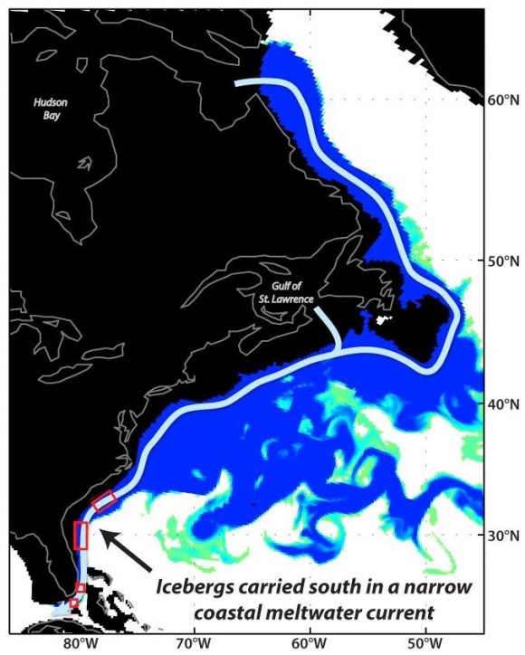
To investigate how icebergs might have drifted as far south as Florida, the scientists simulated the release of a series of glacial meltwater floods in a high-resolution ocean circulation model at four different levels for two locations, Hudson Bay and the Gulf of St. Lawrence.
Condron reports:
In order for icebergs to drift to Florida, our glacial ocean circulation model tells us that enormous volumes of meltwater, similar to a catastrophic glacial lake outburst flood, must have been discharging into the ocean from the Laurentide ice sheet, from either Hudson Bay or the Gulf of St. Lawrence.
Condron’s work, conducted with Jenna Hill of Coastal Carolina University, is described in the current advance online issue of Nature Geosciences.
Bottom line: A new study on ocean circulation suggests that icebergs and meltwater from the North American ice sheet would have regularly reached South Carolina and even southern Florida during the last ice age, about 21,000 year ago.
Like what you read?
Subscribe and receive daily news delivered to your inbox.
More from
Eleanor Imster


