


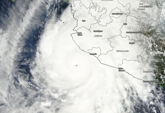
In just 24 hours, Patricia went from a tropical storm to a Category 5 hurricane and the strongest storm ever recorded in the Western Hemisphere. It has now been downgraded from a Category 5 to a Category 2 storm, after making landfall Friday (October 23, 2015) at approximately 6:15 p.m. CDT (2315 UTC) along the coast of southwestern Mexico, in the Cuixmala area of the state of Jalisco. Landfall was 55 miles (85 km) west-northwest of the city of Manzanillo, Mexico’s busiest port. Patricia hit the coast with winds of 165 mph (265 kph).
Mexico’s president President Enrique Pena Nieto said Patricia had so far caused less damage than feared, but warned that it still poses a threat of floods and landslides as it brings heavy rain to parts of the country. He said:
The first reports confirm that the damages have been minor to those corresponding to a hurricane of this magnitude. Nonetheless, it is very important that the population stays in the shelters, the security forces will be patrolling to protect their homes. I repeat, we still can’t let our guard down.
It will likely take several days to find out exactly what kind of damage occurred along the Mexico coast as one of the most powerful hurricanes in our lifetimes made landfall. People will likely need food, water, shelter, and medical assistance. A hurricane’s powerful winds are only one of its dangerous aspects. Storm surge and flooding are other factors. The National Weather Service (NWS) said of Patricia:
Residents in low-lying areas near the coast in the hurricane warning area should evacuate immediately, since the storm surge could be catastrophic.
NWS added that rainfall of 8 to 12 inches (200 to 305 mm) — and possibly 20 inches (half a meter) in some spots:
… could produce life-threatening flash floods and mudslides.
Hurricane #Patricia approaches #Mexico. It’s massive. Be careful! #YearInSpace pic.twitter.com/F5LgnjOjey
— Scott Kelly (@StationCDRKelly) October 23, 2015
Hurricane Patricia intensified to a 200-mph (320-kph) storm early Friday morning.
Patricia’s barometric pressure of 879 millibars (mb) is what makes it the strongest storm to form in the Eastern Pacific and Atlantic basins combined, since record-keeping began.
At the 10 p.m. CDT advisory Wednesday evening, Patricia was a tropical storm with winds of 60 mph (100 kph). Twenty four hours later, at 10 p.m. CDT Thursday night, the tropical cyclone rapidly intensified into a Category 5 hurricane with sustained winds of 160 mph.
By 4 a.m. CDT Friday morning, Patricia had intensified to sustain winds of 200 mph, which is an incredible 135 mph increase in 30 hours.
The lower the pressure, the stronger the storm. For Patricia, the pressure dropped 100 mb in 24 hours, which is the fastest drop seen since record keeping began. With a pressure reading of 879 mb, Patricia became the strongest tropical cyclone ever measured in the Western Hemisphere since record keeping began and the strongest hurricane ever recorded in both the Eastern Pacific and Atlantic basins. The strongest storm ever recorded on Earth was Typhoon Tip back in 1979 with a surface pressure of 870 mb.
RT @RafaAlcalde1 Unbelievable video from #HuracanPatricia May God help the people affected! pic.twitter.com/GYNdDNlyoO
— Adrian Linares (@Adriansweather) October 23, 2015
VIDEO: (unsourced) #PrayForMexico #HurricanePatricia #Patricia pic.twitter.com/P94WdaXgeF
— 3030 (@jose3030) October 24, 2015
Outside the International Space Station, cameras captured dramatic views of Hurricane Patricia at 12:15 p.m. EDT on October 23, 2015:
Meanwhile, tropical storm force winds (39-73 mph) extended 175 miles (280 km). If the storm was the size of Katrina or Haiyan, winds and storm surge would have impacted a much larger area.
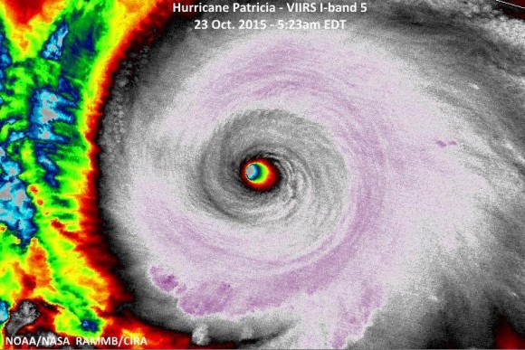
The eye of #Patricia continues to shrink as it approaches landfall this evening. pic.twitter.com/vKVoOpCuVw
— Matt Daniel (@mattdanielwx) October 23, 2015
For perspective, several of the most devastating hurricanes ever to affect the United States were never even close to the intensity of Patricia. Hurricane Katrina had a pressure of 902 mb at peak intensity. Hurricane Andrew was at 922 mb. Hurricane Wilma (2005) holds the record for the strongest hurricane in the Atlantic basin at 882 mb. Remember, the lower the pressure, the stronger the storm.
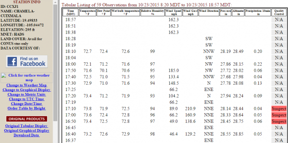
Mesowest observations out of Cuixmala – showing wind speeds in that area – are horrifying to look at. The mesonet station CCXJ1 recorded sustained winds around 160-180 mph. At one point, it measured a wind gust of 210 mph. There are questions on whether or not the information is valid, but it definitely looks possible. Incredibly scary stuff!
Patricia will continue to weaken throughout Saturday as it pushes over land and encounters mountainous terrain. Landslides and flash flooding will be a major concern across Mexico as the storm pushes off to the northeast. Some areas could easily see 6-12 inches (15-30 cm) of rain. The remnants of Patricia will likely combine with a trough across the central United States. It will enhance the moisture across Texas and Louisiana as we head into Monday-Wednesday. Major flooding is possible across Southeast Texas and into Louisiana and Arkansas.
The Weather Prediction Center is forecasting an additional 6-12 inches (15-30 cm) of rain with some spots possibly receiving more than that around the Houston, Texas area.

4pm: Here is an updated rainfall forecast map for tonight through Sunday. #txwx #stxwx #ccwx pic.twitter.com/Ruo0kD2Xgn
— NWS Corpus Christi (@NWSCorpus) October 23, 2015
Why did Patricia intensify so rapidly and become one of the strongest tropical cyclones ever seen? The extremely warm ocean waters in the Eastern Pacific were a major contributor. This is an El Niño year, and such years typically produce unusually warm sea surface temperatures and a favorable atmospheric environment conducive for tropical cyclone development in the Eastern Pacific.
What is more, 2015 is likely to become the warmest year ever recorded globally. The majority of the heat is stored in ocean waters. So the warmer air temperatures for the globe as a whole, too, likely had some influence on the powerful intensification of this storm.
Here is an amazing statistic: in 2015 so far, we have seen 22 storms in the Northern Hemisphere become Category 4 or 5 hurricanes. That’s a new record, surpassing the old record of 18 Category 4 or 5 storms set back in 2004.
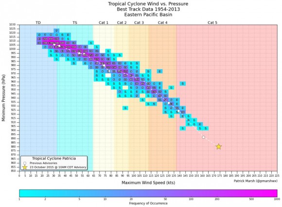
Finally, meteorologist Patrick Marsh posted a graphic showing all the pressure-wind relationship for Eastern Pacific Hurricane Patricia in the context of historical Eastern Pacific tropical cyclones. As you can see in that graphic, below, Patricia (indicated as the star), is nothing like the storms that have formed in that basin since record keeping began.
None of the earlier storms, recorded since 1954, matched the intensity of Patricia.
30-31°C SST & high ocean heat content optimal for Hurricane Max Potential Intensity of 170 knots+. Patricia exceed? pic.twitter.com/ywM0oK9gtl
— Ryan Maue (@RyanMaue) October 23, 2015
Bottom line: Hurricane Patricia – strongest hurricane so far recorded in the Western Hemisphere – had sustained winds of 200 mph and a pressure of 879 mb. Patricia made landfall Friday evening (October 23, 2015) near Cuixmala, Mexico with sustained winds around 165 mph. Although the storm will degenerate as a remnant low, it will produce widespread rain and flooding across Mexico and eventually into Texas and Louisiana. The footage below is from the Hurricane Hunters as they were flying in the eye of Patricia Friday morning and was pushing into the eyewall.
This video was taken during our 2nd center fix today. I started the video while we were in the eye and then flew into the eye wall.
Posted by Joseph Diane Klippel on Thursday, October 22, 2015
Like what you read?
Subscribe and receive daily news delivered to your inbox.
More from
Matt Daniel


